
Day Cloud Phase Satellite Tool Helps Meteorologists Identify Snowpack and Cloud Types Across Michigan, Wisconsin, Illinois, Indiana, and Ohio
UNITED STATES — Meteorologists across the Great Lakes and Midwest, including Michigan, Wisconsin, Illinois, Indiana, and Ohio, rely on a specialized satellite product known as Day Cloud Phase to better understand winter weather conditions at the surface and in the atmosphere.
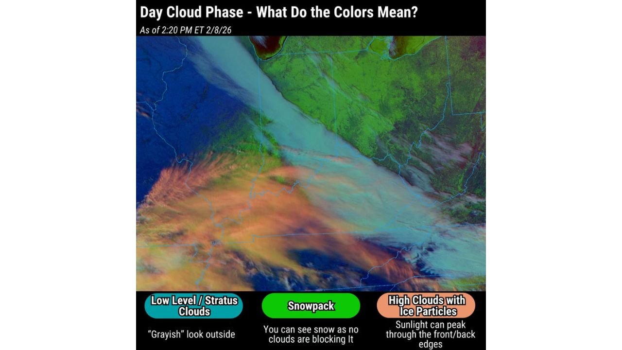
During the winter months, traditional satellite imagery can struggle to distinguish between clouds and snow on the ground, since both often appear white. The Day Cloud Phase tool solves that problem by using color enhancement to clearly separate snowpack, low clouds, and high clouds, giving forecasters a more accurate real-time picture of what is happening across snow-covered regions.
What the Green Areas Mean: Snow on the Ground
In Day Cloud Phase imagery, green shading represents snowpack, meaning snow that is already on the ground with clear skies above it. This is a critical distinction during winter forecasting.
When snowpack is present without cloud cover:
- Overnight temperatures can drop rapidly
- Radiational cooling becomes more efficient
- Forecast lows often end up colder than expected
Without this tool, snow-covered ground can easily be mistaken for cloud cover on standard satellite images.
Identifying Low Clouds Versus High Clouds
The tool also highlights different cloud layers that strongly influence temperatures:
Low-level or stratus clouds
- Appear as muted grayish or bluish shades
- Are thick and reflective
- Block incoming sunlight
- Keep daytime temperatures cooler
- Limit nighttime cooling
High clouds with ice particles
- Appear in warmer orange or peach tones
- Are thin and semi-transparent
- Allow sunlight to filter through during the day
- Trap outgoing heat at night
- Can actually keep temperatures milder
Understanding which cloud type is present helps forecasters refine both daytime highs and overnight lows.
Why This Tool Matters in the Midwest and Great Lakes
Across snow-prone states like Michigan, northern Indiana, northern Illinois, Wisconsin, and Ohio, accurate temperature forecasting depends heavily on:
- Whether snowpack is exposed
- Whether low clouds linger
- Whether high clouds are present to trap heat
Small differences in cloud type can mean temperature swings of 5–15 degrees, especially during calm winter nights.
A Key Advantage Over Standard Satellite Imagery
Day Cloud Phase imagery provides a major advantage during winter because it removes ambiguity. Forecasters can instantly see:
- Where snow is on the ground
- Where clouds are thick enough to suppress warming
- Where thin clouds may allow sunshine but limit overnight cooling
This leads to more accurate forecasts, better cold-weather warnings, and improved confidence during winter events.
As winter continues across the Midwest, tools like Day Cloud Phase remain essential for understanding how snow cover and cloud layers interact — and why temperatures can vary so dramatically from one county to the next.
Stay with WaldronNews.com for continued Midwest winter weather insights, forecast explainers, and regional analysis.