
Presidents Day Storm Signal Reappears on European Model as Rain-Snow Line Wobbles Across the Northeast
UNITED STATES — Long-range weather guidance is once again hinting at a potential Presidents Day weekend storm, with the European (ECMWF) model re-introducing a coastal system affecting the eastern United States. While confidence remains low at this distance, the setup shown in the latest data is enough to put forecasters back into tracking mode.
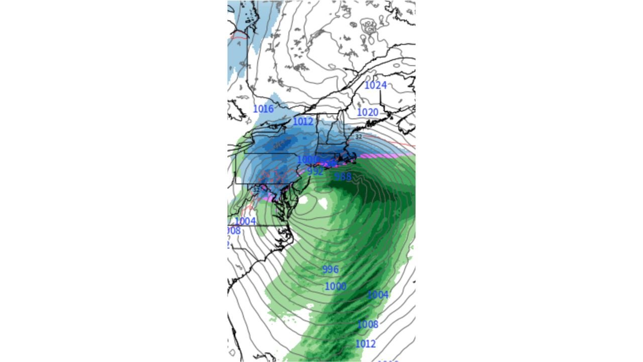
The modeled system features a developing coastal low pressure center, with surface pressures falling into the 988–992 mb range offshore, indicating a moderately strong storm signal. However, thermal profiles and cold air availability remain uncertain, making precipitation type highly dependent on small track shifts.
Coastal Low Tracks Near the Mid-Atlantic Before Intensifying Offshore
The ECMWF depiction shows a storm organizing near the Mid-Atlantic coastline, then strengthening as it moves northeastward offshore. Pressure gradients tighten rapidly east of the coast, a classic signal of increasing wind and expanding precipitation coverage.
Isobars pack tightly around the low, suggesting gusty onshore winds, especially along the coast. Meanwhile, higher pressure remains locked over eastern Canada and northern New England, attempting to feed colder air southward into the system.
This push-and-pull between offshore warmth and inland cold is what keeps the forecast unsettled at this range.
Rain–Snow Line Sets Up Across Interior Northeast and New England
One of the most notable features in the data is the rain-snow transition zone, shown by a narrow band of mixed precipitation extending from parts of the Mid-Atlantic into southern New England.
- Interior and higher-elevation areas lean colder, supporting snow or a snow-dominant mix
- Coastal regions trend warmer, favoring rain or a rain-to-snow change late
- The 32°F isotherm is close to the coast, meaning minor track changes could significantly alter impacts
This setup is very typical for storms at this lead time and explains why forecasters are not crossing off snow potential, despite warmer air showing up in parts of the system.
Cold Air Source Weaker Than Earlier Systems — But Not Gone
Compared to recent winter storms, the cold air feeding this system appears less robust, which introduces risk for more rain than snow in coastal and southern zones. That said, high pressure over the Northeast remains strong enough to prevent a complete warm takeover.
In scenarios like this, dynamic cooling from intensifying precipitation can still flip rain to snow inland, especially overnight or during peak storm strength.
This is why meteorologists caution against locking in outcomes too early.
Typical Long-Range Uncertainty, But Tracking Resumes
At this range, on-again, off-again storm signals are expected, and the current model depiction should be viewed as a renewed signal — not a forecast. Still, the return of a structured low on the ECMWF gives forecasters something tangible to monitor over the coming week.
Key details still to be resolved include:
- Exact storm track
- Strength of cold air supply
- Timing relative to peak heating and overnight cooling
- Rain versus snow ratios inland vs coastal
What Happens Next
Additional model runs over the next several days will determine whether this system:
- Becomes a meaningful winter storm
- Trends toward a mainly rain event
- Or fades as just another long-range signal
For now, the message is simple: Presidents Day weekend is back on the weather radar, and the pattern supports continued monitoring.
WaldronNews.com will continue to track updates as confidence improves and clearer impacts emerge.