
Heavy Rain Targets Tennessee Valley and Lower Ohio Valley From February 13–15 as Frozen Ground Raises Flooding Concerns
UNITED STATES — A developing storm system is expected to bring widespread heavy rainfall across the Tennessee Valley and parts of the Lower Ohio Valley this weekend, increasing the risk of flooding—especially in areas where frozen or partially frozen ground could limit water absorption.
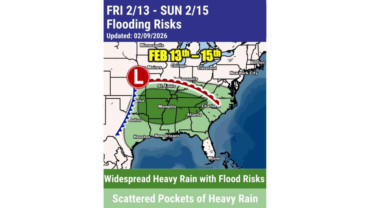
Forecast guidance valid from Friday, February 13 through Sunday, February 15 highlights a broad swath of the central and eastern United States facing elevated runoff concerns as moisture surges northward ahead of a strengthening low-pressure system.
Widespread Heavy Rain Expected Across the Tennessee Valley
The highest confidence for persistent, heavy rainfall is centered on the Tennessee Valley, including portions of:
- Tennessee
- Northern Mississippi
- Northern Alabama
- Western and central Kentucky
These areas fall squarely within the zone marked for widespread heavy rain with flood risks, indicating multiple rounds of rainfall rather than a brief event.
Rainfall efficiency is expected to be high, increasing the likelihood of stream rises, poor-drainage flooding, and water collecting on roadways, particularly in urban and low-lying locations.
Frozen Ground in the Lower Ohio Valley Adds to Flood Risk
Farther north, parts of the Lower Ohio Valley—including areas of southern Illinois, southern Indiana, and western Kentucky—remain vulnerable due to frozen or recently frozen soils.
When rain falls on frozen ground:
- Water cannot soak into the soil
- Runoff increases rapidly
- Smaller creeks and streams can rise quickly
Even moderate rainfall totals in these regions could therefore lead to disproportionate flooding impacts compared to warmer-season events.
Low Pressure System Drives Moisture Northward
The setup shows a surface low tracking from the southern Plains toward the Midwest, dragging a frontal boundary eastward. Ahead of this system, deep moisture spreads north from the Gulf of Mexico into the central and eastern U.S.
This configuration supports:
- Prolonged rainfall over the same areas
- Training rain bands in some locations
- Gradual but steady runoff accumulation
While thunderstorms may be embedded, the primary hazard remains rainfall-driven flooding, not severe weather.
Scattered Heavy Rain Extends Into the Southeast
Beyond the core flood-risk zone, scattered pockets of heavy rain are also expected across parts of:
- Georgia
- The Carolinas
- Portions of the Gulf Coast
While flooding is less likely to be widespread in these areas, localized heavy downpours could still cause temporary drainage issues.
What to Watch Through the Weekend
Residents in affected regions should monitor:
- Small stream and creek levels
- Areas with poor drainage
- Locations that received recent snow or ice
Conditions may change depending on rainfall intensity and duration, especially where frozen ground persists.
Bottom Line
A weekend heavy rain event from February 13–15 is shaping up to bring flooding concerns to the Tennessee Valley and Lower Ohio Valley, with frozen ground increasing runoff potential in northern areas. While rainfall impacts will vary by location, the overall pattern favors widespread wet conditions with localized flooding risks.
WaldronNews.com will continue to provide updates as this system approaches and impacts become clearer.