
Temperature Moderation Expands Across the United States and Canada as Arctic Cold Retreats and Pattern Variety Returns
UNITED STATES — A noticeable moderation trend is now underway across much of North America, signaling a shift away from persistent, entrenched cold toward a more variable temperature pattern that will bring frequent ups and downs every few days.
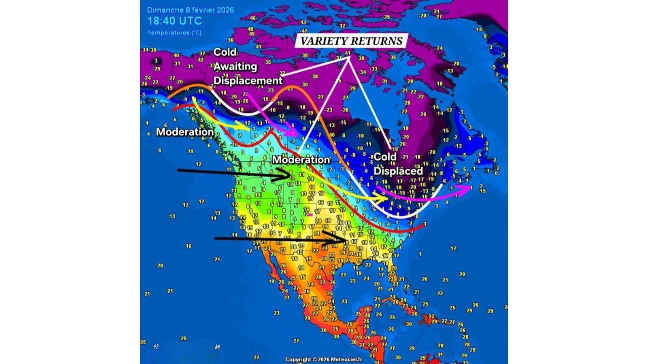
The latest temperature analysis shows arctic air retreating northward, while milder Pacific and southern air masses increasingly penetrate the central and eastern United States. This transition marks a significant change from the recent pattern dominated by deep cold outbreaks.
Arctic Cold Begins to Displace Out of the Lower 48
The data highlights a large reservoir of extreme cold remaining across northern Canada, labeled as “cold awaiting displacement.” Rather than plunging south repeatedly, this cold is now being shunted east and north, reducing its ability to dominate the continental United States.
Across the eastern U.S., the cold air is shown as displaced rather than reinforced, indicating that future cold shots are likely to be short-lived instead of persistent.
Widespread Moderation Takes Hold Across the Central U.S.
A broad zone of moderating temperatures stretches from the West Coast through the Plains and into the Midwest, with readings climbing well above recent norms.
States across:
- The central Plains
- The Midwest
- Portions of the Ohio Valley
are now positioned in a regime where milder air frequently replaces cold, limiting how long below-normal temperatures can hold.
This moderation is reinforced by a more progressive jet stream that prevents cold air from becoming locked in place.
East Coast Still Sees Cold, But With Increasing Variability
While colder air remains present along parts of the Northeast and eastern Canada, the pattern shows this cold is no longer dominant.
Instead, the eastern U.S. is entering a cycle where:
- Brief cold shots move through
- Followed by quick rebounds to milder conditions
This back-and-forth reflects a highly dynamic late-winter setup, rather than a sustained deep-freeze scenario.
Southern U.S. and Mexico Remain Firmly Warm
The southern tier of North America, including Texas, the Gulf Coast, and Mexico, continues to sit under consistently warm conditions, acting as a steady source of mild air pushing northward.
This warmth helps:
- Erode cold air intrusions
- Increase temperature swings
- Promote a more spring-like rhythm
What “Variety Returns” Means Going Forward
The phrase “variety returns” is key. Instead of one dominant air mass controlling the continent, multiple air masses will rotate through:
- Mild periods followed by short cool-downs
- Faster-moving weather systems
- Less extreme and shorter-duration cold outbreaks
This is a classic signal that the atmosphere is transitioning toward a late-winter / early-spring regime.
Bottom Line
North America is moving into a moderation phase, with arctic cold retreating northward and greater temperature variability returning every few days. While cold will still make appearances, it is increasingly displaced and temporary, rather than locked in.
For much of the United States, the pattern ahead favors more frequent warm-ups, fewer prolonged freezes, and a more dynamic weather cycle.
WaldronNews.com will continue tracking how this evolving pattern shapes the remainder of the winter season.