
Western New York Sees Brief Tuesday Thaw Before Lake-Effect Snow Targets Buffalo, Rochester, and Oswego Tuesday Night Through Thursday
NEW YORK — Western New York is set to experience a short-lived temperature rebound on Tuesday, allowing many areas to finally climb above the freezing mark, before a return to winter conditions brings accumulating lake-effect snow from Tuesday night through Thursday.
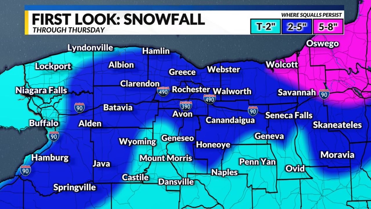
Early guidance suggests minor to locally moderate snowfall totals, with the greatest accumulations focused in areas where lake-effect bands persist the longest. This forecast represents an early look at potential impacts and will continue to be refined.
Tuesday Brings a Brief Break From the Cold
Temperatures across Western New York (WNY) are expected to moderate briefly on Tuesday, providing a temporary thaw after recent cold. This warm-up is expected to be short-lived, as colder air quickly follows behind a passing system.
While the thaw may help with daytime travel, it also sets the stage for lake-effect processes to ramp up once colder air returns over the relatively warmer waters of Lake Ontario.
Lake-Effect Snow Develops Tuesday Night
By Tuesday night, colder air moving across Lake Ontario is expected to initiate lake-effect snow showers, which may persist at times through Thursday.
The forecast highlights a broad zone of snowfall across:
- Buffalo and Niagara Falls
- Rochester and surrounding Monroe County
- Batavia, Albion, and Clarendon
- Webster, Walworth, and Greece
- Geneva, Canandaigua, and the Finger Lakes
- Oswego and eastern Lake Ontario communities
Snowfall Totals Depend on Band Placement
Early accumulation estimates suggest:
- Up to 2 inches in areas where snow bands are weaker or shift frequently
- 2 to 5 inches across much of inland WNY
- 5 to 8 inches possible in localized areas, especially east of Lake Ontario near Oswego, where lake-effect squalls persist
Because lake-effect snow is highly sensitive to wind direction, small shifts in band placement could lead to sharp differences in totals over short distances.
Travel Impacts Possible Where Squalls Persist
Where lake-effect bands become established, periods of reduced visibility and slick road conditions are possible, especially during overnight and early morning hours.
Impacts are expected to be localized rather than widespread, but drivers may encounter rapidly changing conditions when moving in and out of snow bands.
Still an Early Forecast
Forecasters stress this is an early assessment of accumulation potential. Key factors that will influence final snowfall amounts include:
- Wind direction and consistency
- Duration of cold air over Lake Ontario
- How long individual snow bands remain stationary
Updates are expected as higher-resolution data becomes available.
Bottom Line
Western New York will enjoy a brief thaw on Tuesday, but winter makes a quick return as lake-effect snow develops Tuesday night and continues into Thursday. While most areas are looking at minor to moderate snowfall, localized higher totals are possible, particularly east of Lake Ontario.
WaldronNews.com will continue to track lake-effect trends and provide updates as confidence increases.