
Mid-Atlantic Faces Icy Midweek Start Before Potential Weekend Snow as Cold Blocking Pattern Tightens Its Grip
MID-ATLANTIC — A stubborn winter pattern remains firmly in place across the Mid-Atlantic this week, with freezing drizzle possible Wednesday morning north of Baltimore, followed by renewed cold air and a growing signal for additional snow during the upcoming weekend into early next week, according to Canadian GEM model guidance.
Forecasters note that any expected warmup continues to fall short, as polar air and North Atlantic blocking keep the region locked in a wintry regime.
Wednesday Morning Brings Freezing Drizzle Concerns
The first impact arrives early Wednesday morning, when a shallow layer of cold air near the surface may allow freezing drizzle to develop before sunrise, especially north of Baltimore and into parts of central and northern Maryland, southern Pennsylvania, and nearby areas.
While precipitation amounts look light, even a thin glaze of ice can create hazardous travel conditions, particularly on untreated roads, bridges, and overpasses during the morning commute.
Next Cold Front Reinforces Winter Pattern
Behind Wednesday’s system, another cold front sweeps through, reinforcing the colder-than-normal setup. Any lingering hopes of a sustained warmup have diminished, as guidance continues to favor reloading cold air rather than flushing it out.
This persistent chill is being driven by:
- Polar air intrusions
- High-latitude blocking in the North Atlantic
- Limited ability for warmer air to push north and hold
Looking Ahead: Weekend Storm Signal Returns
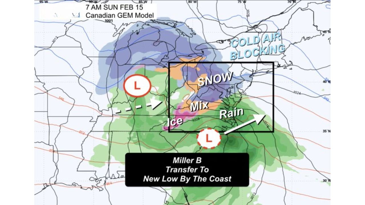
Attention then turns to the Sunday into Monday time frame, where the Canadian GEM model has consistently held onto a storm signal that other models have wavered on.
Current projections suggest:
- A Miller B-type setup, where an inland low transfers energy to a new coastal low
- A complex precipitation shield featuring snow, mixed precipitation, and rain, depending on location
- Cold air blocking to the north, increasing the risk for snow on the northern side of the system
Importantly, the setup has trended colder with each recent model run, raising confidence that snow could play a larger role if the storm materializes.
President’s Week Often Favors Snow
The timing also aligns with President’s Week, a period that historically favors active winter weather across the Mid-Atlantic and Northeast, especially when blocking patterns are present.
While it is far too early to lock in snowfall totals or exact impacts, the pattern supports continued winter threats rather than an early spring break.
Forecast Confidence Still Developing
Forecasters caution that:
- Small track shifts could dramatically change snow, ice, and rain placement
- Thermal profiles will be critical for precipitation type
- Details will evolve over the next several days
This remains a one-week window signal, not a locked-in forecast.
Bottom Line
The Mid-Atlantic remains stuck in a persistent winter pattern, with freezing drizzle possible Wednesday morning north of Baltimore, followed by reinforcing cold air and a growing chance for another snow-producing system late this weekend into early next week. While specifics remain uncertain, winter is far from finished.
WaldronNews.com will continue monitoring model trends and provide updates as confidence increases.