
Colorado Records Its Lowest Snowpack on Record for February 1 as 2026 Drops Below All Modern Benchmarks
COLORADO — Colorado’s statewide snowpack has fallen to its lowest level on record for February 1, according to long-term snow water equivalent (SWE) data, marking a historic low point in the state’s winter season as of 2026.
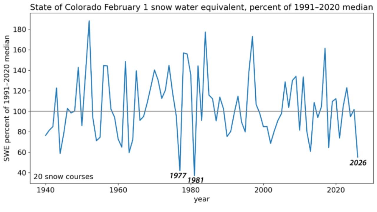
The data shows Colorado’s February 1 snowpack measuring well below the 1991–2020 median, with 2026 now standing as the weakest showing since official statewide records began in 1987. The chart, which aggregates measurements from 20 snow courses across the state, highlights how sharply this year’s snowpack has declined compared to recent decades.
Historical Context Shows Even Worse Winters Before Modern Records
While 2026 holds the lowest position within the modern observational record, analysis suggests that snowpack conditions may have been even worse during earlier drought winters — specifically 1976–77 and 1980–81.
According to analysis referenced from Colorado climate expert Russ Schumacher, those historic winters likely featured lower statewide snowpack than 2026, despite predating today’s standardized measurement system. Those years appear as pronounced troughs on the long-term graph, dropping near or below 40 percent of the modern median.
Because official statewide records only extend back to 1987, those earlier extremes are not formally classified as record lows, even though the visual data strongly suggests they rival — or exceed — current conditions in severity.
How 2026 Compares to Past Decades
The long-term chart shows substantial year-to-year volatility in Colorado’s February snowpack dating back to the 1940s, with periods of well-above-average snow interspersed with sharp collapses.
However, what makes 2026 notable is its placement at the far right edge of the timeline, clearly undercutting all other post-1987 values. While many recent winters have fluctuated between 80 and 120 percent of the median, 2026 drops far below that range, landing among the most depleted snowpacks visible on the entire chart.
Why February 1 Matters
February 1 is a critical benchmark for Colorado’s water supply outlook. Snowpack at this stage plays a major role in determining spring runoff, reservoir recharge, and summer water availability for:
- Municipal water systems
- Agriculture and irrigation
- Hydropower generation
- River ecosystems
A snowpack deficit at this point in the season leaves less margin for recovery, even if late-season storms occur.
A Winter That Stands Out — Even in a Volatile Record
While Colorado has experienced significant snowpack swings for decades, the 2026 reading stands out as a modern extreme. It underscores how current winter conditions rival some of the most severe drought-era snowpack years observed in the historical record.
Whether late-season snowfall can meaningfully offset this deficit remains uncertain, but as of February 1, 2026 has already secured a place among the weakest snowpack seasons Colorado has seen in generations.
WaldronNews.com will continue tracking snowpack trends and their implications for water resources across the West.