
Texas, Oklahoma, Arkansas, and the Central U.S. Likely See Rain — Not Major Winter Storm — as Cold Air Retreats Next Week
UNITED STATES — Forecast guidance suggests the early part of next week will not bring a major winter storm for much of Texas, Oklahoma, Arkansas, and the central United States, as cold air continues to retreat and warmer conditions build northward.
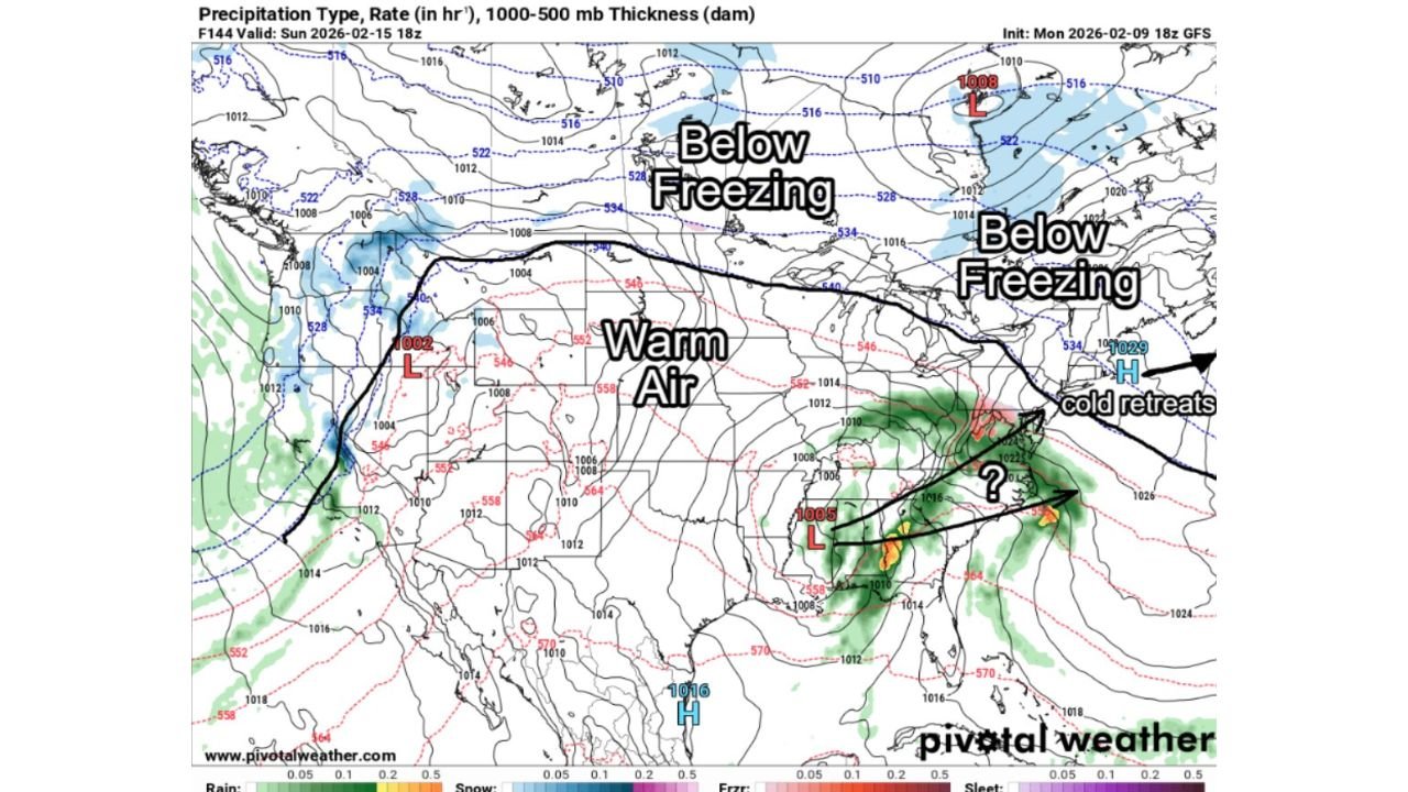
Latest model data shows a warm ridge expanding across the central U.S., pushing true winter air farther north and east. As a result, rain appears to be the dominant precipitation type in nearly every scenario, rather than snow or ice.
Warm Air Expands Across the Central United States
The forecast pattern clearly shows warm air spreading across the Plains and Mid-South, replacing the colder air mass that has been in place earlier this winter. Thickness values and temperature profiles support a setup that favors liquid precipitation across most of the central states.
This includes Texas, Oklahoma, Kansas, Missouri, Arkansas, and parts of the lower Midwest, where temperatures appear too warm to support a widespread winter weather event.
Cold Air Retreats to the North and East
While areas farther north and east remain below freezing, the maps indicate that cold air is retreating away from the central U.S., limiting the southward extent of wintry precipitation.
The boundary separating below-freezing air from warmer air remains well north of the main storm system, reducing the likelihood of snow or ice impacts across the Plains and Mid-South.
Rain Favored in Nearly All Scenarios
Model output consistently shows rain as the primary precipitation type associated with the system. Even in scenarios where precipitation spreads broadly, thermal profiles strongly favor rain over snow or freezing rain for most of the region.
This greatly lowers the odds of a significant winter weather event, especially for Texas, Oklahoma, Arkansas, and surrounding states, where winter storm impacts appear unlikely.
What This Means for Next Week
- No strong signal for a major winter storm in the central U.S.
- Warm air dominates much of Texas, Oklahoma, and Arkansas
- Rain is the most likely precipitation outcome
- Winter impacts remain confined to far northern and eastern regions
While forecast details will continue to evolve, current data strongly suggests that early next week’s system will be more of a rain-maker than a winter storm for most central U.S. states.
Any meaningful winter weather would require a much stronger southward push of cold air — a scenario that does not appear supported by current model trends.
Stay with WaldronNews.com for continued updates as forecast confidence increases and model guidance is refined.