
California and Nevada Face Strong Thunderstorms Tonight With 50 MPH Wind Gusts, Small Hail, Lightning and Possible Waterspouts Along the Coast
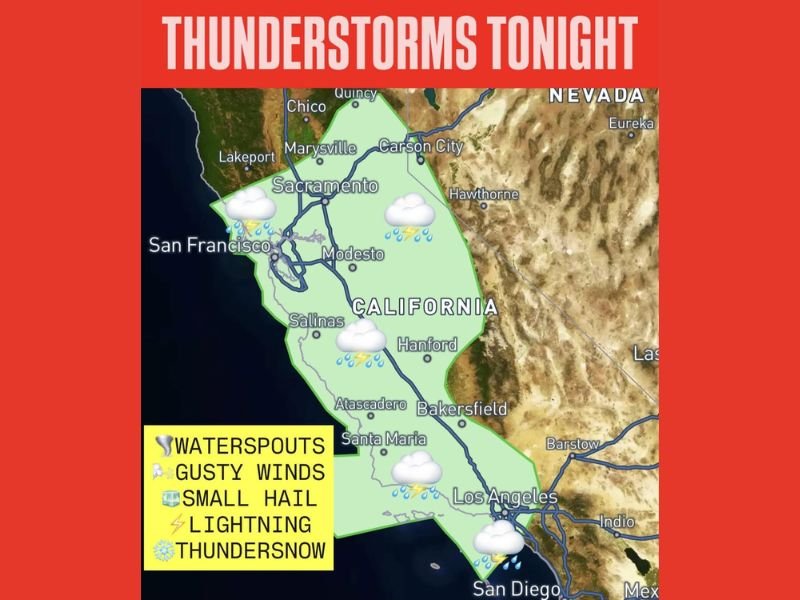
CALIFORNIA — A strong storm system moving into the state this evening is increasing lift and instability, setting the stage for thunderstorms across central and southern California, as well as parts of the Reno–Tahoe region of Nevada, through tonight and into Wednesday.
Forecasters indicate storms may produce 40 to 50 mph wind gusts, lightning, pea-size hail, and isolated stronger cells, with even a small chance of waterspouts developing along the California coastline.
Thunderstorm Risk Expands Across Central and Southern California
The impacted zone stretches from:
- Sacramento
- San Francisco
- Modesto
- Salinas
- Hanford
- Bakersfield
- Santa Maria
- Los Angeles
- San Diego
The storm coverage also extends northeast toward Carson City and the broader Reno–Tahoe territory in Nevada.
The map highlights widespread thunderstorm potential across the Central Valley and coastal regions, with icons indicating lightning and rainfall throughout much of the state.
Strong Winds and Small Hail Possible
Storms developing this evening and overnight could bring:
- Wind gusts up to 40–50 mph
- Frequent lightning
- Pea-size hail
- Brief heavy downpours
- A low-end risk for one or two storms approaching severe levels
While widespread severe weather is not expected, isolated stronger storms could briefly intensify under favorable instability conditions.
Thundersnow Possible in the Sierra Nevada
In higher elevations of the Sierra Nevada, lightning may occur within snow-producing bands — a phenomenon known as thundersnow.
This typically occurs when strong lift and instability overlap with cold air at elevation, creating convective snow bursts.
Low-End Waterspout Risk Along the Coast
With instability building over coastal waters, there is a low-end chance of waterspouts forming offshore along the California coastline.
Waterspouts are typically brief but can produce localized gusty winds and heavy rain if they move inland.
Timing of the Storm System
The greatest thunderstorm activity is expected:
- This evening
- Overnight
- Through Wednesday
As the system continues eastward, impacts may expand into portions of western Nevada, particularly the Reno–Tahoe region.
What Residents Should Expect
Central and southern California residents should be prepared for:
- Sudden wind gusts
- Brief heavy rain
- Lightning
- Small hail
- Travel slowdowns during stronger cells
Mountain communities should monitor for bursts of convective snowfall and lightning. Stay with WaldronNews.com for continued updates as this storm system moves across California and Nevada.