
February 10–12, 1983 Megalopolitan Blizzard Buried Pennsylvania, New Jersey, New York and Southern New England Under 10–30+ Inches of Snow
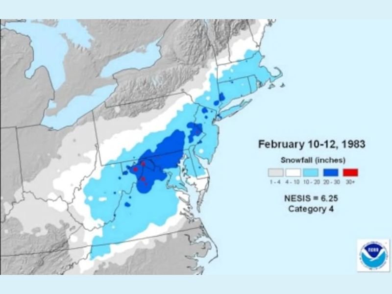
UNITED STATES — February 10–12, 1983 remains one of the most memorable winter storms in modern East Coast history. The powerful Megalopolitan Blizzard of 1983 delivered widespread heavy snowfall from Pennsylvania and New Jersey through New York and into southern New England, leaving behind double-digit accumulations and crippling travel conditions across major metropolitan areas.
The storm, which began during the afternoon hours on February 10 and continued into the morning of February 12, produced snowfall totals ranging from 4 to over 30 inches, with some of the heaviest amounts centered across eastern Pennsylvania, northern New Jersey, and southeastern New York.
Widespread 10–20 Inches Across the I-95 Corridor
The snowfall map shows a broad swath of 10–20 inches stretching from:
- Eastern Pennsylvania
- Northern and Central New Jersey
- New York City and surrounding suburbs
- Lower Hudson Valley
- Southern Connecticut
- Rhode Island
- Portions of Massachusetts
This placed some of the nation’s most densely populated areas directly in the storm’s heaviest band.
Major cities impacted included:
- Philadelphia, PA
- Newark, NJ
- New York City, NY
- Bridgeport & New Haven, CT
- Providence, RI
- Boston, MA (lighter totals compared to areas south)
Localized 20–30+ Inch Totals in Parts of Pennsylvania and New Jersey
The darkest shading on the map highlights localized zones of 20–30+ inches, particularly across:
- Eastern Pennsylvania
- Northern New Jersey
- Portions of Southeastern New York
These higher totals contributed to widespread transportation shutdowns, school closures, and significant disruptions across the Mid-Atlantic and Northeast.
The storm earned a NESIS (Northeast Snowfall Impact Scale) rating of 6.25, placing it in Category 4, which classifies it as a “Crippling” snowstorm in terms of population impact and snowfall distribution.
Southern Edge and Lighter Totals
Farther south into:
- Maryland
- Northern Virginia
- Delaware
Snowfall totals were lighter, generally in the 4–10 inch range, though still impactful. The storm’s southern edge marked a sharp cutoff compared to the intense snow band farther north.
A Storm That Developed Quickly
Reports from that event indicate snow began during the early afternoon on February 10 in parts of the Mid-Atlantic, rapidly accumulating through the evening commute. By the following morning, snowfall totals had already reached significant levels in many areas.
The storm finally wound down late morning on February 12, leaving behind widespread deep snowpack across the Northeast megalopolis.
Why It’s Still Remembered
What made the 1983 Megalopolitan Blizzard so historic was not just the snowfall totals — it was the density of the population impacted. Millions of residents across the heavily urbanized corridor from Philadelphia to Boston experienced major disruptions.
With snowfall exceeding a foot across many metropolitan regions and localized totals topping two feet, the storm remains one of the benchmark Northeast winter events of the 20th century. Stay with WaldronNews.com for more historical weather features, storm anniversaries, and regional climate insights.