
Colorado, Wyoming and Nebraska Face Mountain Snow Surge Along I-70 Corridor as Front Range Braces for Rain/Snow Showers and Active Pattern Next Week
Colorado – A fast-moving storm system is spreading steady mountain snowfall across Colorado’s high country today and into Thursday, with the heaviest accumulation expected along the I-70 corridor near the Continental Divide. At the same time, rain and snow showers are drifting east off the foothills toward the Front Range, I-25 corridor, and eastern plains — including parts of Wyoming and Nebraska.
According to the latest radar and forecast analysis, this is primarily a mountain-focused event, but lower elevations will see occasional showers, especially tonight into early Thursday morning.
Heaviest Snow Targeted Along the Continental Divide
Forecasters indicate the most consistent and intense snowfall will fall between 3 PM this afternoon and Noon Thursday, with the highest probability of accumulation centered on the I-70 corridor through Summit County, Eagle County, and the higher terrain west of Denver.
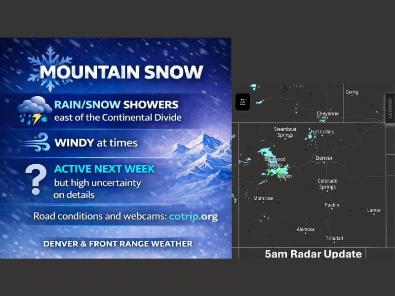
Radar imagery early this morning showed:
- Snow bands over Glenwood Springs, Aspen, and Steamboat Springs
- Expanding precipitation near Fort Collins and Cheyenne
- Light returns west of Denver
Snowfall in the high country is expected to be significant enough to help build the seasonal snowpack, especially above 9,000 feet.
What to Expect in the Mountains:
- Periods of moderate to heavy snow
- Gusty winds at higher elevations (25–35 mph above 9,000 feet)
- Reduced visibility during peak snowfall
- Slushy to snow-packed travel conditions along I-70
Drivers traveling through Vail Pass, Eisenhower Tunnel, and Berthoud Pass should prepare for winter driving conditions through Thursday midday.
Front Range and Eastern Plains: Light Rain/Snow Mix
East of the Continental Divide, precipitation becomes more scattered and lighter.
Cities including:
- Denver
- Colorado Springs
- Fort Collins
- Cheyenne, WY
- Portions of western Nebraska
may see occasional rain/snow showers, mainly tonight into early Thursday morning.
Accumulations in lower elevations are expected to be minimal:
- Trace to 1 inch possible in isolated areas
- Many areas may see little more than brief wet roads
Rainfall amounts are expected to be light overall, with some areas barely recording measurable totals.
Winds Not a Major Concern — For Now
Unlike many recent systems, wind impacts will remain limited outside of higher elevations. Most lower-elevation gusts are expected to remain under 20 mph, while mountain peaks could experience stronger bursts. This keeps blowing snow concerns primarily confined to the highest passes.
Southern Colorado and Southwest Kansas Watching Friday System
Another disturbance is expected to move across southern Colorado Friday into early Saturday, bringing a renewed chance of rain/snow mainly along and south of Highway 50, potentially extending into southwest Kansas. Details remain uncertain, but this secondary system could add additional light accumulation in southern zones.
Weekend Trend: Dry Break Before Active Pattern Returns
After this midweek snow event winds down, the weekend currently looks mostly dry across Colorado, Wyoming, and Nebraska. However, next week turns more complicated.
Early Next Week Outlook:
- Storm #1: Targeted around Tuesday
- Storm #2: Wednesday
- Storm #3: Friday
- Potential continuation beyond that
Forecasters note that storm track will determine who sees significant impacts, especially east of the Continental Divide where confidence remains lower. The highest confidence remains in continued mountain snowfall events, helping maintain and possibly enhance the snowpack.
Travel and Safety Reminders
- Check road conditions before mountain travel
- Monitor webcams and state travel resources
- Allow extra time through high-elevation passes
- Be prepared for rapidly changing visibility
While this is not a major statewide winter storm, it is a solid mountain snow event with travel implications along key Colorado corridors. WaldronNews.com will continue monitoring updates as new model data refines next week’s storm track and potential impacts across the region.