
AI European Model Breaks From the Pack, Projects Sunday Night–Monday Snowstorm Reaching Central New Jersey and the NYC Metro While Other Forecasts Keep It Suppressed South
UNITED STATES — A notable disagreement has emerged in the forecast for Sunday night into Monday, as the AI-driven European model (ECMWF AIFS) is tracking a significantly farther-north snowstorm compared to nearly every other major solution.
While most traditional guidance keeps the system suppressed to the south — focusing heavier snow offshore or across the Mid-Atlantic — the AI EURO deterministic run pushes accumulating snowfall into central New Jersey, brushing the New York City metro, and extending into parts of Long Island and southern New England.
At this point, it stands clearly as the northern outlier.
What the AI European Model Is Showing
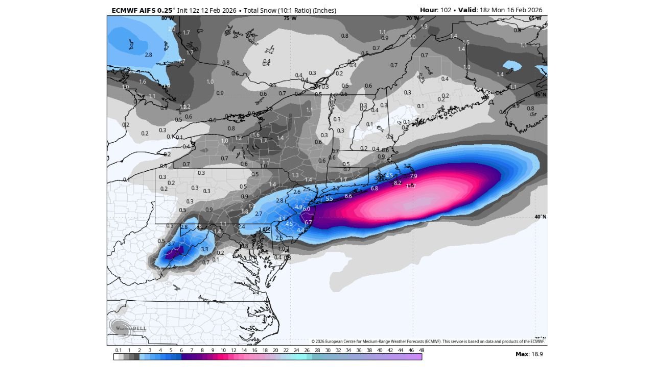
The ECMWF AIFS 0.25° snowfall projection (10:1 ratio), valid Monday evening, depicts a pronounced snow band lifting northward along the Mid-Atlantic coast.
Key highlights from the model map include:
- Central and southern New Jersey: Several inches of snow, with locally higher totals along the coastal plain
- New York City metro area: Light to moderate accumulations possible under this solution
- Long Island: Accumulating snowfall extending eastward
- Coastal waters east of New Jersey and Long Island: A stronger offshore band with significantly higher totals
The most intense snowfall core in the model remains offshore, but the western edge of that band clips populated areas along the I-95 corridor — something other guidance does not currently emphasize.
How This Differs From Most Other Forecasts
Most traditional operational and ensemble guidance keeps the storm track farther south, limiting meaningful snow impacts to:
- Southern New Jersey
- Coastal Delaware
- Eastern Maryland
- Areas well offshore
In those solutions, northern New Jersey and New York City either receive minimal snow or remain largely dry.
The AI EURO run, however, shifts the precipitation shield northward — a subtle but important adjustment in storm track that dramatically increases snow potential along the urban corridor.
Snowfall Distribution on the Map
The model’s heaviest snowfall bullseye is offshore, but measurable accumulation spreads inland across:
- Philadelphia suburbs
- Much of New Jersey
- The NYC metro region
- Portions of Long Island
North and west of the I-95 corridor — including interior Pennsylvania, the Hudson Valley, and much of upstate New York — totals are generally lighter in this specific run, indicating the primary coastal focus of the storm.
Why This Matters
Even a modest northward shift in coastal storm track can mean the difference between:
- A glancing light snow event
- Or a more impactful accumulating snowfall in densely populated areas
The AI European model appears to be detecting a slightly stronger or differently positioned coastal low, allowing precipitation to arc farther inland before pulling away into the Atlantic.
Whether that represents a genuine emerging trend — or simply model noise — remains to be seen.
Is This a Trend or Just an Outlier?
At the moment, the AI EURO solution stands apart from the majority cluster of guidance.
However, forecasters often monitor outliers closely because:
- They sometimes identify subtle pattern shifts earlier than ensemble averages
- Coastal storms are highly sensitive to track changes of 50–100 miles
- Small adjustments in upper-level energy can dramatically alter snowfall placement
If subsequent runs begin trending north, confidence in a broader snow footprint would increase.
If not, this solution may remain an isolated outlier.
What Residents in New Jersey and NYC Should Watch
For residents in:
- Central and northern New Jersey
- New York City
- Long Island
The key factors to monitor include:
- Future model consistency
- Ensemble support for a northward track
- Temperature profiles Sunday night into Monday
At this stage, widespread significant snowfall in the NYC metro is not the consensus forecast — but it is no longer off the table given this latest AI-driven run.
Bottom Line
The Sunday night–Monday storm remains highly track-dependent.
Most guidance keeps the storm suppressed south of the major Northeast metro areas. But the AI European model is signaling a potential northward adjustment that would bring accumulating snow into central New Jersey and possibly the New York City region.
It’s an outlier — but one worth bookmarking.
WaldronNews.com will continue monitoring model trends closely as we approach the weekend and provide updated guidance as clarity improves.