
Minor Sunday Night Snowstorm Could Disrupt Travel from Baltimore to New York City as 2–4 Inches Target Central Maryland and Coastal New Jersey
UNITED STATES — A minor but potentially disruptive snowstorm is increasingly possible Sunday night into early Monday, with accumulating snow stretching from central Maryland through northern New Jersey and into the New York City metro area.
Forecasters warn this may not be a blockbuster winter storm — but it could be just enough to create travel delays and slick roads during the Monday morning commute, especially from Baltimore to New York City.
Snow Timeline: Sunday Night into Monday Morning
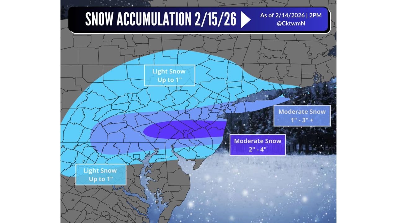
The latest snowfall outlook valid February 15–16 shows precipitation developing Sunday evening and continuing overnight into early Monday.
Key impacts are expected during:
- Late Sunday night
- Early Monday morning commute
- Peak travel hours along the I-95 corridor
The storm’s northern and central axis appears most favored for accumulating snow, while areas south of the primary band could see more mixing.
Where the Heaviest Snow Is Expected
The forecast map highlights a moderate snowfall “bullseye” centered across:
- Central Maryland
- Areas near and north of Baltimore
- Northern portions of the Chesapeake region
- Parts of coastal New Jersey
Snowfall Projections:
- Moderate Snow (2″ – 4″)
Focused from central Maryland northeastward into portions of coastal New Jersey. - Moderate Snow (1″ – 3″+)
Extending toward the NYC metro region. - Light Snow (Up to 1″)
Across northern Maryland, southern Pennsylvania, and farther south into parts of Virginia.
Cities most at risk for meaningful accumulation include:
- Baltimore, MD
- Northern suburbs of Washington, D.C.
- Central and northern New Jersey
- Potentially the NYC metro area
Mixing Line Critical for Southern Areas
Forecasters emphasize that locations south of the core snow band — especially southern Maryland and areas closer to the Chesapeake Bay — may experience mixing with rain.
This is important because:
- A slight northward shift would increase totals across D.C.
- A slight southward shift would cut totals dramatically in Maryland
This remains a track-sensitive system.
Why Even a “Minor” Storm Matters
While snowfall amounts are not extreme, timing is everything.
If snow falls steadily between midnight and 7 a.m. Monday:
- Highways could become slick
- School delays are possible
- Airport delays may ripple from Baltimore to NYC
- Commuter rail disruptions cannot be ruled out
Even 2–3 inches falling overnight can create hazardous conditions before road crews fully respond.
Travel Concerns from Baltimore to NYC
The I-95 corridor from:
- Baltimore
- Through Wilmington
- Across central New Jersey
- Into New York City
sits directly within the projected accumulation zone.
Any moderate snowfall during peak commuting hours could slow traffic significantly.
Final Takeaway
This system may not make headlines for extreme totals, but it carries real potential for disruption — especially across central Maryland and the Mid-Atlantic urban corridor.
Snowfall of 2 to 4 inches in the most favored zone could be enough to create slick roads and travel delays Monday morning from Baltimore to New York City.
WaldronNews.com will continue monitoring track adjustments and updated snowfall projections as the storm approaches.