
Louisiana and East Texas Face Nocturnal Tornado Threat as Squall Line Strengthens; SPC Signals Tornado Watch Likely with Isolated EF2+ Risk
UNITED STATES — A dangerous line of severe storms is organizing across East Texas and pushing toward Louisiana tonight, bringing a heightened risk for damaging winds, large hail, and potentially tornadoes — including a low-end chance of an isolated significant (EF2+) tornado.
Forecasters warn that the greatest concern will unfold after dark, when a fast-moving squall line with embedded rotations sweeps eastward across the region.
Squall Line Intensifying Across East Texas
Latest radar analysis shows a well-defined line of storms extending from near College Station and Houston northeast toward Tyler and Palestine, with strong winds and rotation embedded within the line.
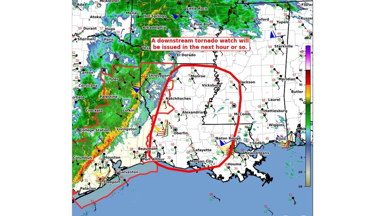
This system is moving east into western Louisiana, targeting communities including:
- Shreveport
- Natchitoches
- Alexandria
- Lake Charles
- Lafayette
- Baton Rouge
- New Orleans
The Storm Prediction Center’s Mesoscale Discussion #78 indicates that a tornado watch is likely within the next hour or so, covering a broad portion of western and central Louisiana.
Tornado Risk — Including Isolated Significant Threat
While most tornadoes expected tonight would likely be brief and embedded within the line, meteorologists are not ruling out:
- Quick spin-up tornadoes
- Embedded mesovortices within the squall line
- A low-end risk of an isolated EF2+ tornado
The discussion highlights a 95% probability of watch issuance, signaling strong confidence that conditions support severe weather.
Peak intensity estimates suggest:
- Tornado potential: 100–130 mph winds
- Straight-line wind gusts: 65–80 mph
Nocturnal tornadoes are especially dangerous because many residents are asleep when warnings are issued.
Areas Most at Risk Tonight
The red-outlined risk area spans:
- Eastern Texas (including Tyler and Lufkin)
- Western and central Louisiana (including Shreveport, Alexandria, and Baton Rouge)
- Portions of southern Mississippi near McComb
Storms will continue progressing east overnight toward:
- Jackson, Mississippi
- Hattiesburg
- The Mississippi Gulf Coast
Why This Setup Is Concerning
This is not a classic isolated supercell outbreak. Instead, it is a linear squall line with embedded kinks and areas of rotation, which can produce:
- Rapid tornado development
- Brief but damaging spin-ups
- Widespread wind damage
Because the system is occurring at night, visibility will be limited — making radar-based warnings critical.
Safety Message for Louisiana Residents
With a tornado watch expected shortly and warnings possible later tonight:
- Keep phones charged and alerts enabled.
- Have multiple ways to receive warnings.
- Know your safe place — an interior room away from windows.
- If a warning is issued, take shelter immediately.
The window of highest concern will be through late evening into the overnight hours as the squall line pushes east.
WaldronNews.com will continue tracking updates on tornado watch issuance and any warnings that develop across Louisiana and surrounding states.