
Six Active Tornado Warnings Sweep Louisiana from Lake Arthur to Marksville as QLCS Storm Line Charges Toward the Mississippi River
UNITED STATES — A dangerous line of storms is tearing across central and southwestern Louisiana tonight, prompting six active tornado warnings stretching from south of Lake Arthur northward past Marksville, with the northern cluster expected to approach the Mississippi River within the next hour.
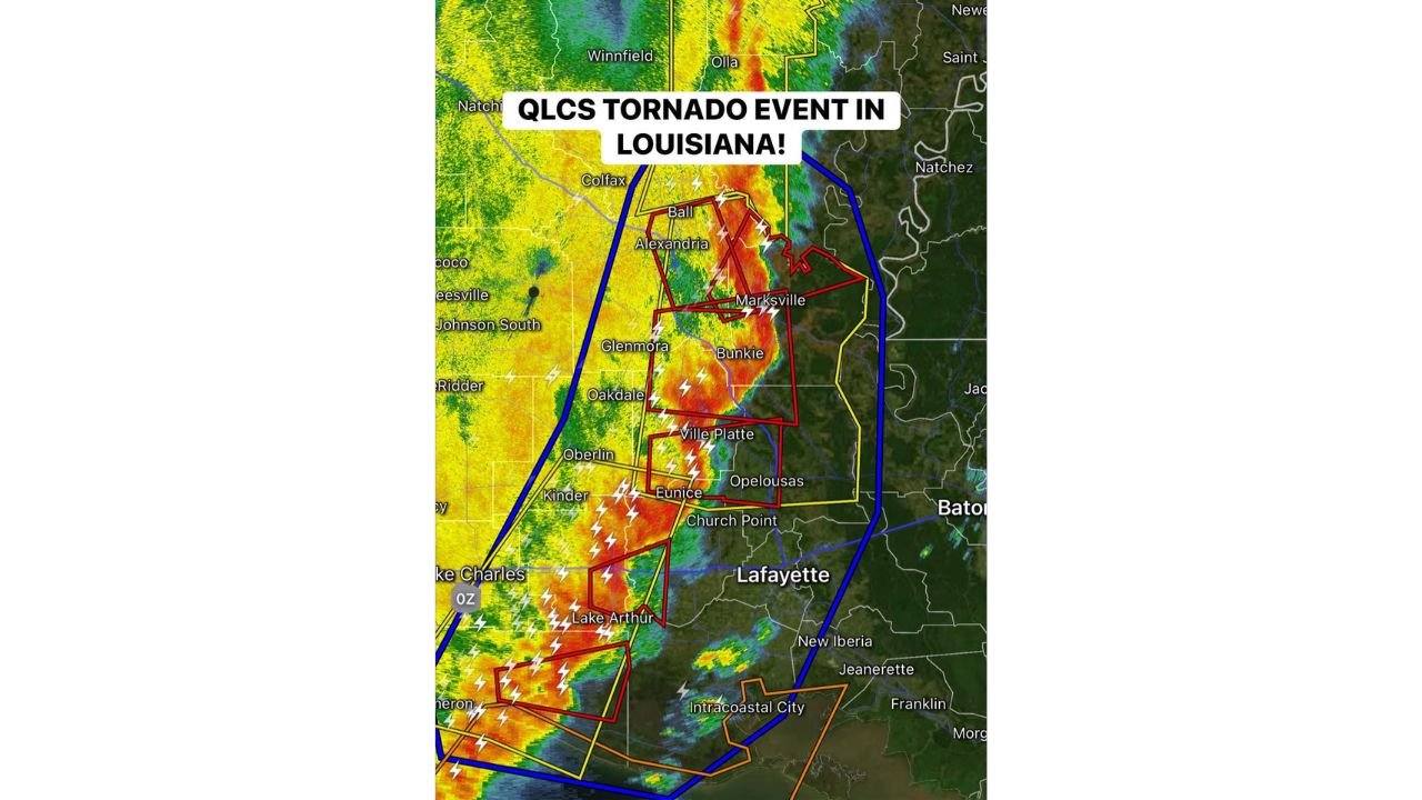
Meteorologists confirm this is a QLCS (Quasi-Linear Convective System) tornado event, meaning tornadoes are embedded within a fast-moving squall line rather than isolated supercells — a setup that can produce rapid, hard-to-see spin-ups.
Tornado Warnings From Lake Arthur to Marksville
Radar imagery shows a solid, bowing line of intense thunderstorms moving east-northeast across:
- Lake Arthur
- Kinder
- Eunice
- Ville Platte
- Bunkie
- Alexandria
- Marksville
Multiple warning polygons are clustered along this corridor, indicating ongoing tornado potential within different segments of the line.
The strongest reflectivity cores — shown in deep reds — align with areas of rotation embedded in the storm structure.
Northern Cluster Nearing the Mississippi River
The northern warning cluster centered near Alexandria and Marksville is advancing east and will approach the Mississippi River corridor shortly.
Communities downstream that should remain alert include:
- Areas west of Natchez
- Portions of central Mississippi
- Locations east of the Louisiana state line
These embedded circulations can spin up quickly and produce short-lived tornadoes with little lead time.
What Makes QLCS Tornado Events Dangerous
Unlike classic long-track supercells, QLCS tornadoes:
- Develop rapidly along the leading edge of a squall line
- Can be rain-wrapped and difficult to see
- Often occur at night
- Are capable of producing brief but damaging tornadoes
The line also carries:
- Frequent lightning
- Torrential rainfall
- Damaging straight-line wind gusts
Wind damage alone could exceed 60–70 mph in some areas.
High-Impact Corridor Through Central Louisiana
The most intense stretch currently extends from:
- Lake Arthur and Port Arthur region
- Through Kinder and Eunice
- Into Ville Platte and Alexandria
- North toward Marksville
Communities in this corridor should remain sheltered until warnings expire.
Safety Reminder
If you are within any active tornado warning:
- Move to an interior room on the lowest floor.
- Stay away from windows.
- Use helmets or sturdy protection if available.
- Do not attempt to outrun a tornado at night.
With multiple warnings active and storms racing eastward, this remains a fast-evolving and potentially dangerous situation.
WaldronNews.com will continue monitoring tornado warning updates and storm progression across Louisiana and toward Mississippi.