
Louisiana Squall Line Weakening Overnight but Heavy Rain to Reach Mobile and Baldwin Counties Around 4–5 AM Sunday
UNITED STATES — The intense line of storms that tore across Louisiana earlier is expected to continue pushing east overnight, reaching Southwest Alabama — including Mobile and Baldwin counties — between 4:00 and 5:00 AM Sunday morning. However, forecast guidance indicates the line should gradually weaken as it moves east.
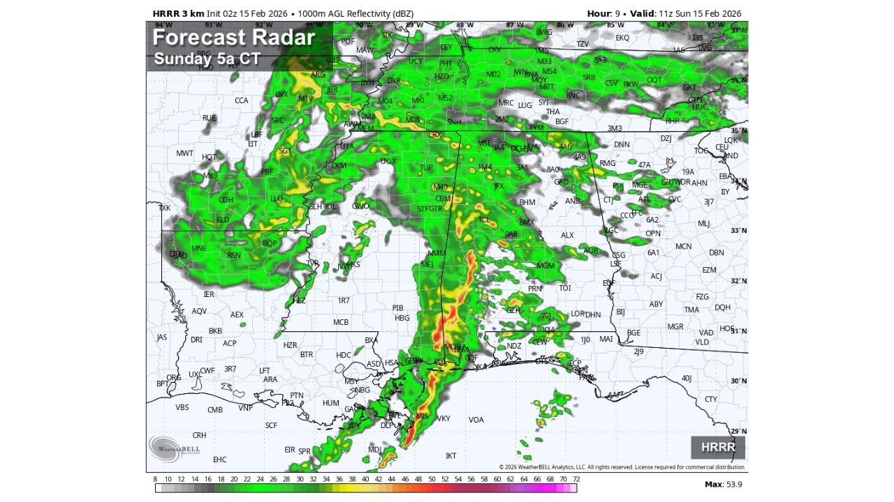
High-resolution HRRR forecast radar valid around 5 AM CT Sunday shows the once-solid Louisiana squall line beginning to fragment as it crosses into southern Mississippi and approaches coastal Alabama.
Storm Line Timing Into Alabama
The leading edge of rain and embedded thunderstorms is forecast to track from:
- Southeast Louisiana
- Coastal Mississippi
- Into Mobile County
- Across Baldwin County
- Toward the western Florida Panhandle
Arrival window for Southwest Alabama: 4:00–5:00 AM CT
The strongest remaining segment of the line appears near the immediate Gulf Coast, with heavier rain pockets embedded within the broader shield.
Why the Line Is Expected to Weaken
Forecasters note that as the storms push east:
- Atmospheric instability decreases
- Lapse rates become poor
- Surface-based energy becomes limited
These factors should reduce the severe storm potential compared to what Louisiana experienced earlier.
Severe Threat Level for Mobile and Baldwin Counties
The overall severe weather threat for:
- Mobile County
- Baldwin County
is considered low, but not zero.
Brief gusty winds and isolated thunder are still possible as the line moves through. The strongest wind cores appear offshore and along the immediate coastal band.
Residents should remain weather-aware overnight, particularly as storms move through before sunrise when visibility is limited.
Rest of Alabama: Mainly Rain
For the remainder of Alabama — including:
- Montgomery
- Birmingham
- Tuscaloosa
- Auburn
- Huntsville
The forecast indicates periods of rain with some embedded thunder, but no organized severe threat is expected.
Rain coverage will be widespread across central and northern Alabama, but reflectivity values suggest mainly moderate rainfall with occasional heavier pockets.
Gulf Coast Conditions
Along the Gulf Coast:
- Heavier rain bands remain concentrated from southeast Louisiana into coastal Mississippi.
- Some stronger radar returns extend offshore into the Gulf.
- Lightning remains embedded within the coastal band.
While weakening is expected, coastal communities should still prepare for brief heavy downpours.
What to Expect Through Sunday Morning
- Rain arrives in Southwest Alabama before sunrise.
- Heavier pockets possible along the immediate coast.
- Limited instability reduces tornado and damaging wind potential.
- Widespread rain continues eastward through the morning hours.
Overnight storms can still produce localized impacts even in weakening phases, especially in coastal zones.
WaldronNews.com will continue monitoring the progression of this system as it moves through Alabama and into the Florida Panhandle.