
Southern California Faces Isolated Tornado Threat Monday Morning as Squall Line Targets Los Angeles, Ventura and Santa Barbara Counties
SOUTHERN CALIFORNIA — A powerful cold front sweeping in from the Pacific is setting the stage for an unusual isolated tornado threat across Southern California early Monday morning, including parts of the Los Angeles metro area. Forecasters are highlighting a developing squall line capable of producing damaging winds, heavy downpours, and brief embedded tornadoes as it pushes east through coastal communities.
The system is expected to impact areas from Goleta and Santa Barbara south through Ventura, Oxnard, Thousand Oaks, Malibu, Santa Monica and greater Los Angeles, especially communities near the coastline.
Strengthening Low Pressure System Drives the Setup
Weather data shows a strengthening low-pressure system positioned to the north of California. As this system intensifies, it will swing a sharp cold front eastward across the region during the mid to late morning hours Monday.
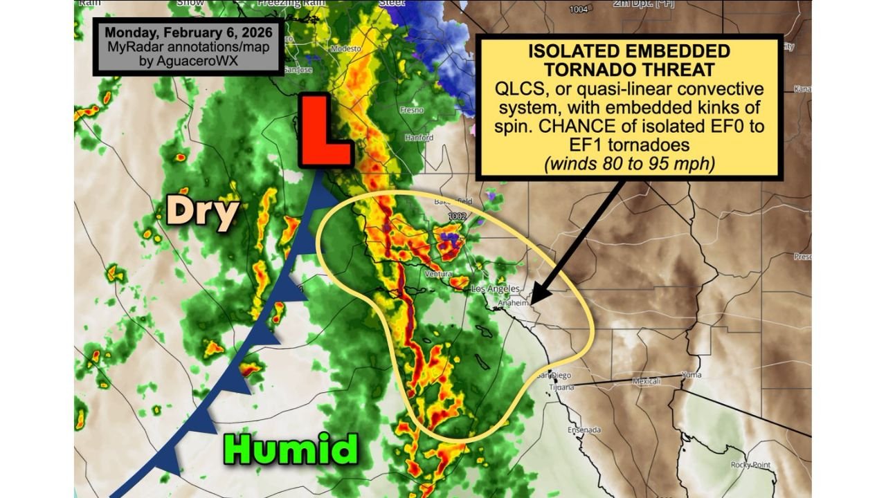
Along this boundary, meteorologists expect a quasi-linear convective system (QLCS) — essentially a solid line of intense storms — to develop and surge inland. Within that line, small “kinks” or circulations may form, creating the potential for isolated tornadoes.
While Southern California is not known for frequent tornado activity, setups like this can occasionally produce brief EF0 to EF1 tornadoes, particularly when strong upper-level winds align with surface instability.
Coastal Cities in the Primary Impact Zone
The highest concern appears to be centered along coastal and near-coastal communities, including:
- Goleta
- Santa Barbara
- Ventura
- Oxnard
- Thousand Oaks
- Malibu
- Santa Monica
- Los Angeles metro area
The storm line is forecast to move eastward through these areas during the morning hours, bringing a burst of hazardous weather in a relatively short time window.
Damaging Straight-Line Winds of 50–60 MPH Likely
In addition to tornado potential, the greater and more widespread threat will likely come from powerful straight-line winds. With the jet stream racing overhead, there will be significant wind energy available for storms to tap into.
Forecast guidance indicates that segments of the squall line could mix down stronger winds from aloft, producing 50 to 60 mph gusts at the surface. These winds are capable of:
- Downing small tree limbs
- Causing isolated power outages
- Blowing debris into roadways
- Creating hazardous driving conditions
Localized areas may experience even stronger gusts in heavier downpours.
Isolated EF0 to EF1 Tornado Risk
The embedded tornado threat stems from changing wind direction and speed with height — a condition known as wind shear. When wind speeds increase rapidly with altitude, storms can rotate briefly within a squall line.
Current projections indicate a chance for isolated EF0 to EF1 tornadoes, with potential wind speeds ranging from 80 to 95 mph in any brief circulation that develops.
These tornadoes, if they form, would likely be short-lived and fast-moving. However, even brief tornadoes can cause localized structural damage and down trees.
Heavy Downpours and Thunderstorms Along the Front
As the cold front advances, a band of intense rainfall and thunderstorms will accompany it. Short bursts of heavy rain could reduce visibility rapidly and lead to minor street flooding in poor drainage areas.
Drivers during the morning commute should remain alert for sudden weather changes, especially along coastal highways and inland routes leading into Los Angeles County.
Timing and What to Expect
- Early to mid-morning: Squall line begins impacting Santa Barbara and Ventura counties.
- Mid to late morning: Storms push into Los Angeles County and coastal metro areas.
- Late morning: Line continues eastward inland, gradually weakening.
Because the threat is embedded within a narrow but intense line of storms, conditions could deteriorate quickly and improve just as fast once the front passes.
Why This Setup Is Unusual for Southern California
Southern California typically experiences winter storms with steady rainfall rather than organized severe thunderstorm lines. However, when strong upper-level winds align with a sharp cold front and sufficient moisture, brief severe episodes can occur.
This event highlights how even regions not traditionally associated with tornadoes can experience isolated spin-ups under the right atmospheric conditions.
Safety Tips for Monday Morning
Residents in the affected areas should:
- Monitor local weather updates before heading out.
- Secure loose outdoor items.
- Be prepared for sudden strong wind gusts.
- Have multiple ways to receive warnings, especially if thunder develops.
If a tornado warning is issued, move indoors immediately and seek shelter in an interior room away from windows.
Southern California residents should stay weather-aware through Monday morning as this dynamic system moves through. While widespread tornado activity is not expected, the combination of strong winds, heavy rain, and isolated rotation makes this a storm system worth taking seriously.
For continued updates and detailed regional coverage, stay connected with WaldronNews.com.