
Great Lakes Spring Storm Set to Slam Michigan, Wisconsin, Illinois, Indiana and Ohio on February 18 — Snow, Ice, Rain and Thunderstorms All Possible
UNITED STATES — A messy spring storm system is on track to impact the Great Lakes region on Wednesday, February 18, 2026, bringing a wide range of precipitation types from heavy snow and mixed ice to soaking rain and even thunderstorms.
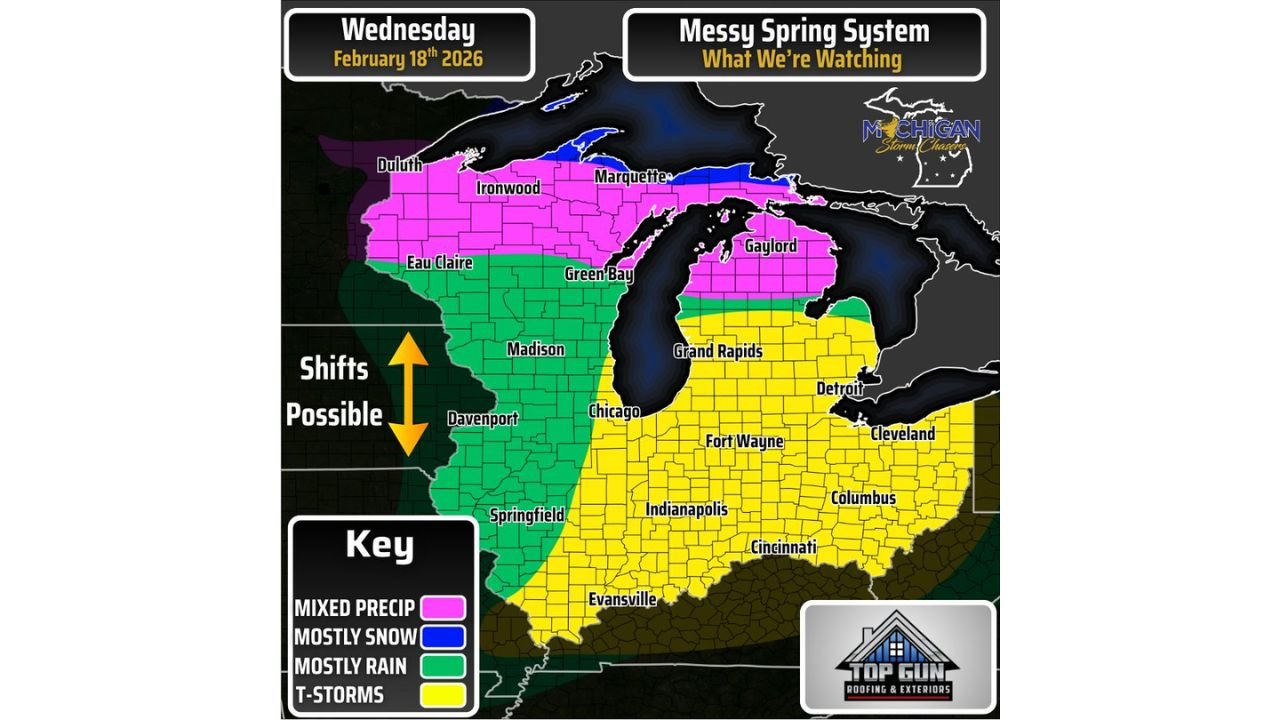
Forecast graphics show a sharp north-to-south transition zone cutting directly through the Upper Midwest and Great Lakes, meaning small shifts in the storm track could significantly change impacts for cities across Michigan, Wisconsin, Illinois, Indiana, and Ohio.
Snow and Mixed Precipitation Across Northern Wisconsin and Upper Michigan
The northern tier of the system will feature wintry weather, particularly across:
- Duluth, Minnesota
- Ironwood, Michigan
- Marquette, Michigan
- Gaylord, Michigan
- Northern Wisconsin including areas near Eau Claire
These areas are positioned in the pink and blue shaded zones on the forecast map, indicating mixed precipitation and periods of mostly snow.
Upper Michigan appears especially vulnerable to prolonged mixed precipitation — including snow, sleet, and possibly freezing rain — which could create slick travel conditions across Marquette and Gaylord. The system’s cold side will dominate near Lake Superior, increasing the likelihood of accumulating snowfall.
Rain for Madison, Chicago and Western Illinois
Farther south and west, the precipitation type shifts to mostly rain. Areas in the green zone include:
- Madison, Wisconsin
- Davenport, Iowa
- Springfield, Illinois
- Chicago, Illinois
These cities are expected to see mainly rainfall as warmer air surges northward ahead of the system. However, the rain/snow line appears close enough to Chicago that even a minor track adjustment could introduce brief mixing.
The graphic highlights that shifts are possible, meaning the rain-to-snow boundary could wobble north or south depending on storm strength and temperature profiles.
Heavy Rain and Thunderstorm Risk for Indiana and Ohio
The southern and southeastern portion of the system — shaded in yellow — signals the potential for:
- Thunderstorms
- Heavy rainfall
- Gusty winds
Cities in this zone include:
- Indianapolis, Indiana
- Fort Wayne, Indiana
- Evansville, Indiana
- Cincinnati, Ohio
- Columbus, Ohio
- Detroit, Michigan
- Cleveland, Ohio
- Grand Rapids, Michigan
This region will sit firmly in the warm sector of the storm, allowing for instability to develop. While severe weather specifics are not yet confirmed, the setup could mark one of the first thunderstorm events of 2026 for parts of the Midwest.
Detroit and Cleveland appear positioned near the rain/thunderstorm corridor, though a slight shift north could introduce brief mixing.
Why This Storm Is Complex
This system is being described as “messy” because it features:
- A tight temperature gradient
- Multiple precipitation types occurring simultaneously
- A strong warm surge ahead of the low-pressure center
- A cold backside capable of producing snow and ice
Such setups are common during late winter and early spring transitions, when cold Arctic air and advancing warmer air masses collide across the Great Lakes.
Track Shifts Will Matter
The forecast graphic clearly notes “Shifts Possible.” That means:
- If the storm tracks farther north, rain could push deeper into Michigan and Wisconsin.
- If it shifts south, snow and ice could expand farther into Chicago, Detroit, or even parts of Indiana and Ohio.
Residents across the region should closely monitor updated snowfall, ice, and rainfall projections as higher-resolution models refine the system’s exact path.
What to Expect Wednesday
By Wednesday, February 18:
- Northern areas may contend with snow-covered roads.
- Central zones could experience cold rain.
- Southern regions may hear thunder and see heavier downpours.
Travel across the Great Lakes corridor could become challenging where precipitation transitions occur, particularly near the Michigan-Wisconsin border and across central Lower Michigan.
WaldronNews.com will continue to monitor model updates and provide refined snowfall and rain totals as the first-call forecast graphics are released later today.