
Polar Vortex Locked in Canada as Powerful Storm Spins Across the South, While 70s Surge Into South Dakota and the Gulf Coast Heats Up
UNITED STATES — A sprawling storm system is sweeping across the Deep South and Mid-Atlantic, but forecasters say the most extreme Arctic air remains locked up in Canada — preventing what could have been a crippling ice storm for much of the Southeast.
Satellite imagery shows a massive cloud shield stretching from Texas across the Gulf Coast and into the Carolinas and Mid-Atlantic, marking the path of the current storm system. While heavy precipitation is ongoing in parts of the eastern U.S., the true polar vortex core remains displaced well to the north across Canada.
Arctic Air Contained North of the Border
The key takeaway from this setup is what isn’t happening.
The coldest Arctic air mass — often associated with the “polar vortex” — remains bottled up in Canada. Had that air plunged southward into the Southeast and Mid-Atlantic, this storm could have evolved into a widespread freezing rain and ice event.
Instead, temperatures across much of the southern U.S. are far too warm to support a “glacier-maker” scenario.
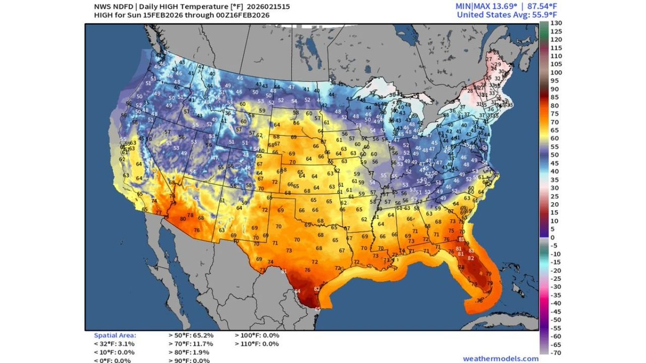
70s Surge North Into the Plains
Temperature forecast maps show a dramatic warm push surging northward into the central United States.
Highs this Sunday are expected to reach:
- 70s across Texas
- Low to mid 70s into Oklahoma and Kansas
- Upper 60s to low 70s into South Dakota
In fact, parts of South Dakota are forecast to reach the 70-degree mark — an unusually warm reading for mid-February.
The warmth stretches from the Desert Southwest across the Southern Plains and into portions of the central U.S., with a sharp gradient northward into colder air across the Upper Midwest and northern Rockies.
Gulf Coast and Florida Feel Early Spring
The Gulf Coast region appears particularly warm, with widespread 70s and even low 80s forecast across:
- South Texas
- Louisiana
- Mississippi
- Alabama
- Florida Panhandle
- Central and South Florida
Some spots in South Florida are forecast to approach the mid-80s.
This warm, moisture-rich air is helping to fuel the current storm system as it tracks eastward.
Sharp Temperature Contrast Across the Midwest
While the southern tier warms dramatically, colder air remains entrenched across:
- Minnesota
- Wisconsin
- Michigan
- Northern portions of the Northeast
Temperatures in these regions remain in the 30s and 40s, with even colder readings in parts of the northern Rockies and Upper Midwest.
The clash between this colder northern air and the surging southern warmth is what’s energizing the ongoing storm system.
Why This Setup Matters
This pattern highlights a classic late-winter contrast:
- Arctic air locked in Canada
- Warm, unstable air surging north from the Gulf
- A powerful storm riding along the boundary between the two
If the Arctic air had been positioned farther south, widespread ice accumulations could have impacted states from Georgia to Virginia. Instead, most of the Southeast remains in the warm sector of the system.
Looking Ahead
With the polar vortex core still displaced northward, additional temperature swings remain possible in the coming weeks. Late winter patterns often feature dramatic back-and-forth shifts between warm surges and cold snaps.
For now, the Southeast and Plains are getting a taste of spring, while the northern tier stays locked in cooler conditions.
WaldronNews.com will continue tracking temperature trends and storm developments as this dynamic February pattern unfolds.