
Major Snowfall Headed for Intermountain West Through February 25 as Colorado, Utah, Idaho and California Mountains See Widespread 1–3 Feet
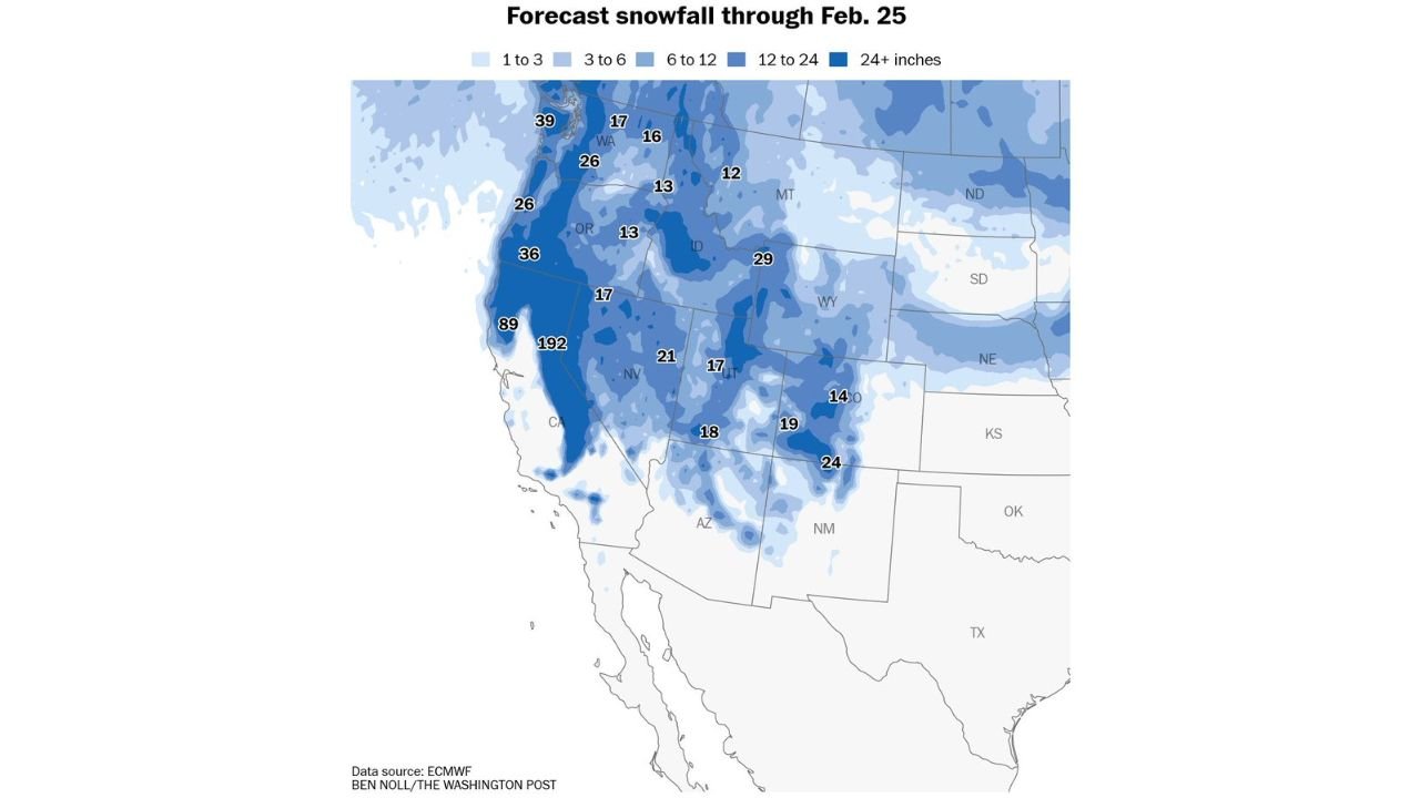
UNITED STATES — A significant round of snowfall is forecast to blanket the snow drought–stricken Intermountain West through February 25, delivering widespread double-digit totals across the mountains of California, Oregon, Washington, Idaho, Utah, Nevada, Colorado, Wyoming and New Mexico.
While the incoming snow won’t completely erase long-term moisture deficits, forecasters say meaningful relief is on the way for many high-elevation areas that have been running well below seasonal averages.
Sierra Nevada Could See Measured Snow in Feet
The most eye-catching totals appear in the Sierra Nevada of California, where projected snowfall through February 25 shows:
- Widespread 24+ inches
- Isolated higher elevations potentially exceeding several feet
- Localized peaks along the central Sierra displaying extreme totals
Numbers highlighted on the map show some locations with exceptionally high accumulations, underscoring the intensity of the incoming pattern.
The heaviest snow band stretches along the spine of the Sierra from northern California southward, offering a critical boost to snowpack in a region heavily dependent on mountain runoff.
Pacific Northwest Mountains Also Targeted
Significant snowfall is also projected across:
- Washington Cascades (30+ inch pockets in higher elevations)
- Oregon Cascades
- Portions of western Washington near the Olympic Peninsula
Forecast markers show:
- 39 inches in parts of Washington
- 36 inches in portions of Oregon
- 26 inches in select higher terrain zones
These totals will benefit reservoirs and late-season snowpack across the Northwest.
Northern Rockies and Idaho in the Crosshairs
Moving inland, heavy snow extends into:
- Idaho
- Western Montana
- Western Wyoming
Forecast values across Idaho and western Montana frequently show:
- 12 to 29 inches in mountain regions
- Widespread 6–12 inches even outside the highest peaks
This corridor of snow will significantly improve mountain snowpack that has lagged in portions of the northern Rockies.
Utah, Colorado and Wyoming Mountains See Strong Totals
The central Rockies also stand to benefit.
Projected snowfall totals include:
- Utah Wasatch Range: 17 to 21 inches
- Colorado Rockies: 14 to 24 inches
- Parts of Wyoming: near 29 inches in favored high terrain
Colorado’s mountain corridor, critical for downstream water supply across the Southwest, could see widespread 1–2 foot totals.
Snow Extends into Nevada, Arizona and New Mexico High Terrain
Even the typically drier interior mountain ranges are forecast to pick up meaningful snowfall:
- Nevada mountains: 17 to 21 inches
- Northern Arizona high country: near 18 inches
- Northern New Mexico mountains: around 19 to 24 inches
While valley locations will see much lighter amounts, higher elevations across the Four Corners region should see solid accumulations.
Not a Drought-Buster — But Meaningful Relief
Despite the impressive totals, experts caution that:
- Long-term drought conditions require sustained precipitation
- Snowpack deficits accumulated over months won’t vanish from one storm cycle
However, widespread 12–36 inch totals across multiple mountain ranges represent a strong step toward seasonal recovery.
What This Means Moving Forward
The upcoming snow pattern signals:
- Improved snowpack in key watershed areas
- Better spring runoff potential
- Enhanced reservoir outlooks if follow-up systems continue
The Intermountain West has been waiting for a pattern shift, and through February 25, that shift appears to be delivering.
WaldronNews.com will continue tracking snowfall updates and potential additional storm systems as the end-of-month pattern evolves.