
Powerful Coastal Storm Could Explode Off Mid-Atlantic and New England Sunday, 50/50 Shot at Major Snow From Washington, D.C. to Boston
UNITED STATES — Forecast guidance is increasingly pointing toward a developing storm system off the Mid-Atlantic and New England coastline late Sunday into Monday, with model projections showing a rapidly deepening low-pressure center just offshore. While confidence is growing that a storm will form, the exact track remains uncertain — and that will determine who sees significant snowfall and who misses out.
Right now, forecasters are calling it roughly a 50/50 scenario for impactful snow somewhere between Washington, D.C. and Boston.
Coastal Low Development Taking Shape
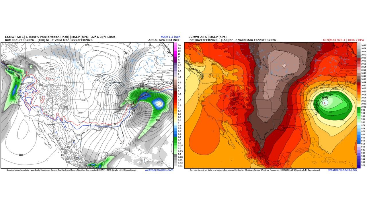
Latest ECMWF guidance shows a strengthening low-pressure system consolidating off the Mid-Atlantic coast, with central pressure dropping into the upper 970s mb range in some projections. That is a sign of a potentially intense coastal storm.
The projected surface low forms east of:
- Virginia
- Maryland
- Delaware
- New Jersey
And then lifts northeast toward southern New England.
Pressure gradients tighten significantly along the coast, which would support:
- Strong coastal winds
- Heavy precipitation bands
- Rapid intensification offshore
Snowfall Potential Hinges on Storm Track
The critical question now is positioning.
If the low tracks slightly west and closer to the coastline, colder air wrapping into the system could support accumulating snow from:
- Washington, D.C.
- Baltimore, Maryland
- Philadelphia, Pennsylvania
- New York City
- Hartford, Connecticut
- Providence, Rhode Island
- Boston, Massachusetts
However, if the storm stays farther offshore, heavier snow bands could shift east and primarily impact coastal New England, with lesser totals inland.
That is why odds remain near 50/50 at this range.
Thermal Setup Supports Snow — But Margins Matter
Model output shows the 32°F and 35°F boundary lines pressing southward across parts of the Mid-Atlantic and interior Northeast. That suggests cold air is available — but not overwhelmingly locked in.
Small shifts in:
- Storm intensity
- Track proximity
- Timing of cold air arrival
Could dramatically change snowfall totals across major cities.
Wind and Coastal Impacts Also Possible
The projected 979 mb low in the western Atlantic would create a strong pressure gradient along the East Coast.
That means even areas that miss the heaviest snow could still experience:
- Gusty winds
- Coastal rough surf
- Reduced visibility during heavier precipitation bands
Who Should Monitor Closely?
Residents from:
- Northern Virginia
- Maryland
- Delaware
- New Jersey
- Eastern Pennsylvania
- Southern New York
- Connecticut
- Rhode Island
- Massachusetts
Should monitor forecast updates closely through the next 48 hours.
Confidence in storm formation is increasing. Confidence in exact snowfall placement is not.
Bottom Line
A developing coastal storm Sunday into Monday has the potential to become a high-impact late-February system for parts of the Mid-Atlantic and New England.
There is roughly a 50/50 chance that a corridor from Washington, D.C. to Boston could see significant snowfall — but track uncertainty remains the deciding factor.
If the pieces align, snowfall and coastal impacts could be substantial. If not, the heaviest bands may stay just offshore.
WaldronNews.com will continue providing updated track and snowfall outlooks as new model data comes in.