
Mid-Atlantic and Northeast on Alert as Potential Sunday–Monday Winter Storm Targets Pennsylvania, New Jersey, New York and New England
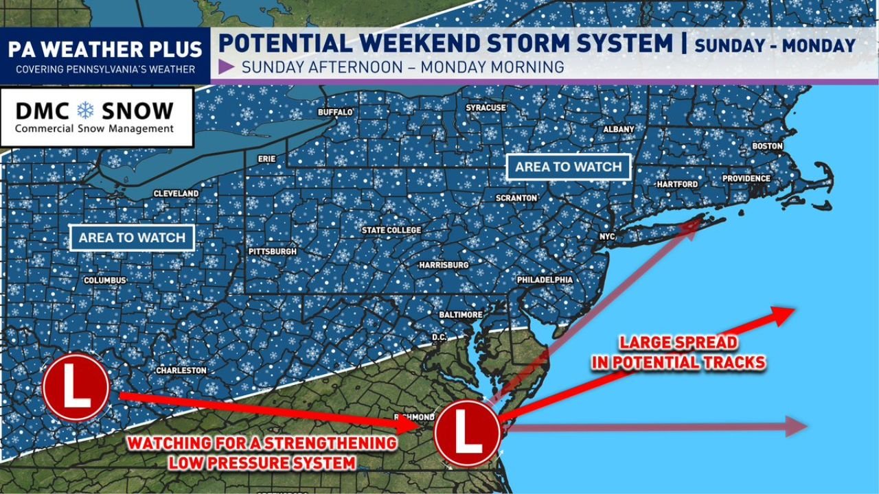
PENNSYLVANIA — A developing winter weather pattern is raising the possibility of a significant Sunday afternoon through Monday morning snowstorm across parts of the Mid-Atlantic and Northeast, with Pennsylvania, New Jersey, New York, and southern New England squarely in the “area to watch.”
Forecast guidance shows a strengthening low-pressure system that could track near the East Coast, but meteorologists caution that while the setup is becoming favorable, the exact track — and therefore snowfall impacts — remain highly uncertain.
Sunday Afternoon Through Monday Morning: The Primary Window
The current projection highlights Sunday afternoon into early Monday as the most likely timeframe for impacts if the storm materializes.
Key atmospheric ingredients coming together include:
- A decaying -NAO block over the North Atlantic
- A classic “50/50 low” setup helping slow and organize the pattern
- A spiking western ridge, encouraging downstream amplification
- Support for a strengthening East Coast surface low
This combination can promote a coastal storm that intensifies near the Mid-Atlantic shoreline before tracking northeast. When these pieces align properly, significant snowfall becomes possible.
However, we are still several days out, and even small shifts in track could dramatically change outcomes.
Pennsylvania, New Jersey, New York and New England in the “Area to Watch”
The highlighted “Area to Watch” stretches across:
- Much of Pennsylvania
- Northern and central New Jersey
- The New York City metro
- Upstate New York
- Portions of Connecticut, Rhode Island, and Massachusetts
- Into western areas near Ohio
Cities such as Pittsburgh, Harrisburg, Scranton, Philadelphia, Baltimore, New York City, Hartford, Albany, and Boston are all within the broader monitoring zone.
If the storm strengthens and tracks near the coast, widespread accumulating snow would be possible across these areas. But if the track hugs the shoreline or shifts inland, parts of eastern Pennsylvania and New Jersey could see mixing issues with sleet or rain.
Track Uncertainty Is the Biggest Wild Card
Forecast maps show a large spread in potential low-pressure tracks.
Two main scenarios are being watched:
Inland or Coast-Hugging Track
- Greater mixing risk for southeastern Pennsylvania and southern New Jersey
- Snow-to-sleet or snow-to-rain transitions possible
- Heaviest snow shifts farther inland or north
Slightly Offshore Track
- Colder air holds firm
- Heavier snowfall potential from central Pennsylvania through northern New Jersey and into southern New England
- More widespread snow impacts for major cities
Because this storm is still about five days out, meteorologists emphasize that any snowfall maps circulating now are not reliable. Model spreads remain broad, and final placement of the heaviest snow band could shift north or south by 100+ miles.
Why This Setup Has “Big Storm” Potential
The atmospheric structure resembles patterns that have previously produced impactful East Coast snowstorms.
If the system phases properly and deepens near the coast:
- Strong lift could produce moderate to heavy snowfall rates
- Coastal low pressure could intensify rapidly
- Wind-driven impacts may accompany snowfall
- Travel disruptions could extend from Sunday evening into Monday morning commute hours
Forecasters note that if all pieces align, impacts could be similar to a late-January style winter storm event.
But again — that outcome is not locked in.
What Residents Should Do Now
For those in:
- Pennsylvania
- New Jersey
- New York
- Delaware
- Maryland
- Connecticut, Rhode Island, Massachusetts
This is not the time to focus on exact snowfall totals.
Instead:
- Monitor trusted forecast updates daily
- Watch for track adjustments
- Prepare for possible travel impacts Sunday night into Monday
- Understand that the storm could still trend weaker, stronger, north, or south
If you prefer early heads-up information, this is your notice that the pattern is supportive. If you prefer waiting until 24–48 hours before impact, more refined guidance will arrive later this week.
Bottom Line for WaldronNews Readers
A potentially impactful Sunday–Monday winter storm is on the table for parts of the Mid-Atlantic and Northeast, including Pennsylvania, New Jersey, New York, and southern New England.
The atmospheric setup supports a strengthening coastal low, but track uncertainty remains significant. The difference between heavy snow and mixed precipitation will depend on subtle shifts in storm evolution over the next several days.
Winter is not done yet.
WaldronNews will continue tracking model trends and provide updated timing, track expectations, and potential impact zones as confidence increases.