
Powerful Jet Stream Clash Sets Stage for Possible Midwest to Mid-Atlantic Snowstorm This Weekend — But Major Models Strongly Disagree
UNITED STATES — A volatile late-winter setup is taking shape for the upcoming weekend as forecast models signal a strong jet stream diving across the central United States, potentially triggering storm development from the Midwest into the Mid-Atlantic and Northeast. However, confidence remains limited as the two primary global models show very different outcomes.
Here is a detailed breakdown of what the latest data indicates.
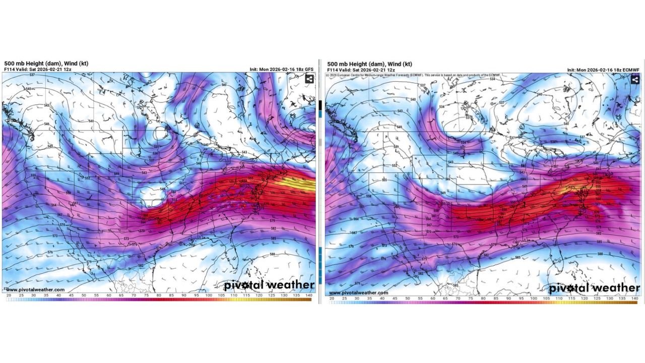
GFS Model Signals Organized Storm and Snow Potential
The latest GFS run highlights a powerful southern jet streak extending from Texas across the Deep South and lifting toward the East Coast by Saturday into Sunday.
At the 500 mb level, winds exceeding 110 to 130 knots stretch from the southern Plains into the Southeast and Mid-Atlantic. This type of upper-level energy often supports storm development if atmospheric components align properly.
On the precipitation-type guidance valid Saturday morning:
- Snow appears across eastern Kansas into central and southern Missouri.
- Heavier precipitation cores are shown near Springfield, Rolla, Clinton, and toward the St. Louis region.
- A transition zone is visible farther south into northern Arkansas near Mountain Home.
- Rain dominates across deeper portions of Arkansas and the southern Ozarks.
If this solution verifies, accumulating snow could extend from:
- Missouri
- Illinois
- Indiana
- Kentucky
- Into portions of the Ohio Valley
- Possibly into Pennsylvania, New Jersey, and southern New York depending on storm evolution
The key factor in this scenario is the development of a consolidated surface low that strengthens as it tracks east or northeast.
ECMWF (Euro) Model Shows Flatter, Weaker Wave
In contrast, the ECMWF model presents a much less aggressive solution.
Rather than consolidating northern and southern stream energy, the Euro keeps the system more progressive and flatter. The upper-level trough remains open, and no strong closed low forms inland.
On its 500 mb analysis:
- The southern jet remains strong.
- The trough does not deepen significantly.
- Surface low development is weaker and less organized.
Under this scenario, snowfall would likely be lighter and more limited, with a greater emphasis on rain or mixed precipitation in some areas. The overall storm impact would be significantly reduced compared to the GFS depiction.
At roughly four to five days out, this level of model disagreement is not unusual.
Why Phasing Matters
Both models agree that a strong jet stream will be in place. The uncertainty centers on whether northern and southern stream energy will “phase,” or merge, in time to strengthen the system.
If phasing occurs:
- Surface pressure falls would intensify.
- Snow bands could organize northwest of the low track.
- A more impactful winter event would be possible across parts of the Midwest and Mid-Atlantic.
If phasing fails:
- The system remains weaker.
- Snowfall coverage decreases.
- Precipitation may be lighter or more scattered.
Even minor shifts in storm track — 100 to 150 miles — could drastically change who sees accumulating snow versus rain.
Areas That Should Monitor Trends
Based on the current range of outcomes, areas that should continue monitoring include:
- Eastern Kansas
- Missouri
- Southern Illinois
- Indiana
- Kentucky
- Ohio Valley states
- Pennsylvania
- New Jersey
- Southern New York
Track and timing will determine eventual impacts.
Snowfall Totals Remain Premature
At this stage, specific snowfall amounts are not reliable. Thermal profiles, storm intensity, and track placement remain unresolved in the guidance.
Model trends over the next 24 to 48 hours will be critical in determining whether this becomes a notable late-season snow event or a more modest system.
Bottom Line
- A strong jet stream setup is in place.
- The GFS shows a more organized snow-producing storm.
- The ECMWF keeps the system weaker and flatter.
- Confidence in impacts remains moderate to low.
- Significant forecast adjustments remain possible.
WaldronNews.com will continue monitoring model trends closely. Residents across the Midwest, Ohio Valley, and Mid-Atlantic should stay informed as the weekend approaches and forecast clarity improves.