
Illinois, Missouri, Iowa, Indiana and Kentucky Brace for Potentially Significant Severe Weather Outbreak Thursday with Tornadoes, Large Hail and Damaging Winds Possible
ILLINOIS — A potentially significant severe weather setup is taking shape for Thursday afternoon and evening across eastern Missouri, southeast Iowa, much of Illinois, and into Indiana and Kentucky, as atmospheric ingredients begin aligning for isolated supercells capable of producing tornadoes, large hail, and damaging wind gusts.
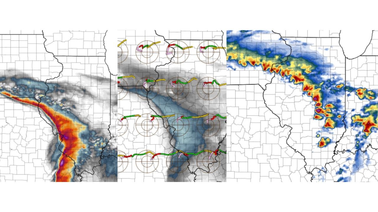
Forecast guidance and severe probability outlooks highlight a focused corridor stretching from eastern Missouri into central and western Illinois, where the highest risk appears to be consolidating.
Highest Severe Risk Shifting into Eastern Missouri and Illinois
Updated severe probability graphics show the most concentrated threat zone centered over eastern Missouri, southeast Iowa, and a large portion of Illinois. This includes areas near:
- St. Louis, Missouri
- Quincy, Illinois
- Springfield, Illinois
- Peoria, Illinois
- Western and central Indiana
- Western Kentucky
Model guidance suggests a surface low tracking across the Ohio Valley will help sharpen a lifting warm front through Missouri and Illinois. As that boundary moves north, it will create a focused zone where storms can tap into richer low-level moisture and wind shear.
The combination of these elements increases the potential for discrete, rotating supercells rather than just a messy line of storms.
Atmospheric Ingredients Coming Together
Forecast analysis indicates several key severe weather parameters are aligning:
- A strong 50–70 knot mid-level jet core
- Mid to upper 50s dew points pooling along a subtle dryline bulge
- Impressive hodographs indicating strong directional wind shear
- Sufficient 0–3 km surface-based CAPE to support rotating updrafts
This combination is supportive of isolated supercells developing along the warm front and ahead of advancing dry air.
The presence of a dry air punch moving in behind the boundary could enhance storm intensity by increasing instability and improving storm structure. When dry air wraps into developing storms, it can sometimes enhance downdrafts and increase the risk for damaging wind gusts.
Tornado Potential Cannot Be Ignored
With strong low-level wind shear and curved hodographs shown in forecast soundings, the setup supports a tornado risk — particularly in areas where storms remain discrete and interact with the warm front.
All severe hazards appear to be on the table if current trends continue:
- Damaging straight-line winds
- Large hail
- A couple of tornadoes, potentially stronger if storm organization maximizes
Eastern Missouri into western and central Illinois currently appears to be the corridor where supercells could become most robust during the afternoon hours before transitioning east toward Indiana and Kentucky.
Timing and What to Expect
Storm development is most likely Thursday afternoon into early evening, beginning in eastern Missouri and spreading eastward.
Areas in Illinois — especially central and western counties — should monitor conditions closely during the mid-to-late afternoon window. Indiana and Kentucky may see storms shift in later toward evening.
Small-scale details such as exact warm front placement and how quickly instability recovers behind morning cloud cover will determine how significant the outbreak becomes. Even minor adjustments in boundary location can dramatically shift the tornado corridor north or south by several counties.
Stay Weather-Aware Across the Region
Residents across Illinois, Missouri, Iowa, Indiana, and Kentucky should review severe weather safety plans ahead of Thursday.
If watches or warnings are issued:
- Have multiple ways to receive alerts
- Know your safe shelter location
- Avoid relying solely on outdoor sirens
This setup has the potential to produce impactful storms if current trends hold. While uncertainty remains in specific storm tracks and intensity, the environment is increasingly favorable for a noteworthy severe weather day.
WaldronNews.com will continue tracking updates as forecast data refines. If you live in the highlighted corridor across Illinois and surrounding states, stay alert and prepared as Thursday approaches.