
Baltimore Metro Faces Uncertain Sunday–Monday Storm as Model Odds for 3” Snow Range From 10% to 50%
BALTIMORE, MARYLAND – A Sunday into Monday system is still on the table for the Mid-Atlantic, but the latest ensemble guidance shows a wide spread in snowfall probabilities, especially for the Baltimore metro area. While it will not be exceptionally cold, the setup could feature a rain-to-snow transition. The key question now is how much accumulation is realistically on the table.
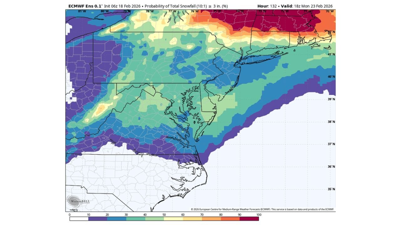
European Model Shows Highest Snow Odds for Baltimore
The latest ECMWF Ensemble (Euro Ens) probability map for at least 3 inches of snow (10:1 ratio) valid Monday evening shows:
- 40–50% probability for the Baltimore metro area
- Higher probabilities north and northeast of Baltimore, especially across central and northern Pennsylvania into southern New York
- A sharp gradient south of Baltimore where rain may dominate longer
This indicates that nearly half of the ensemble members support a measurable, plowable snowfall potential for parts of the metro — but not a lock by any means.
GFS Ensemble Much Less Impressive
The GFS Ensemble paints a very different picture:
- Only around 10% probability of reaching 3 inches in Baltimore
- Stronger signals for accumulating snow confined mainly to areas farther north and northwest
- Much of central Maryland shown with limited or marginal accumulation odds
In this scenario, Baltimore would likely see more rain or a brief changeover with minor totals.
Canadian Ensemble Splits the Difference
The CMC Ensemble sits in between the Euro and GFS solutions:
- Roughly 20–30% probability of at least 3 inches in Baltimore
- Better chances west and northwest of the city
- Lower odds closer to the southern Chesapeake Bay
This suggests a moderate risk, but not enough consistency to call for a high-confidence snowfall event.
Temperature Profile: Not Exceptionally Cold
One of the bigger limiting factors is the lack of deep cold air in place. Forecast discussion notes indicate:
- Temperatures will not be especially cold at the onset
- A rain-to-snow scenario is possible as the system evolves
- Accumulation potential may depend heavily on timing, dynamic cooling, and how quickly colder air filters in
If precipitation rates are strong enough during the transition, snow could briefly accumulate. If not, much of the event may lean wet or slushy.
Where Confidence Is Higher
Across the maps, confidence increases:
- North of Baltimore into southern Pennsylvania
- Farther north into upstate New York, where probabilities exceed 60–80% for 3 inches
Meanwhile, areas south of Baltimore and across southern Maryland show much lower probabilities.
Why The Spread Is So Wide
Ensemble disagreement usually points to uncertainty in:
- Track of the surface low
- Timing of the rain-to-snow changeover
- Strength of cooling aloft
- Precipitation intensity during the transition phase
A slight track shift north or south could dramatically alter snowfall totals in the Baltimore metro.
Bottom Line for Baltimore and Surrounding Areas
At this point:
- Euro Ens: 40–50% chance of ≥3”
- CMC Ens: 20–30% chance
- GFS Ens: Around 10% chance
That spread tells the story — this is not a high-confidence snow event yet. Baltimore remains in the “possible but uncertain” zone, with northern areas favored for better accumulation.
Another update later today should help narrow the range.
For continued Mid-Atlantic storm coverage and model breakdowns without the hype, stay with WaldronNews.com and check back for the latest forecast adjustments.