
Potential Nor’easter Could Bring Heavy Snow to New York, New Jersey, Pennsylvania and New England From Sunday Into Monday
NORTHEASTERN UNITED STATES — A winter storm is looking increasingly likely to impact the Northeast this weekend, with the potential for widespread accumulating snow from Sunday into Monday. Forecast confidence is trending upward for a broad swath of snowfall, especially closer to the I-95 corridor and into coastal New England—where heavier bands could set up if the storm strengthens quickly and tracks close enough to the coastline.
Storm Timeline: Sunday Into Monday
The current setup points to snow developing as the storm organizes offshore, then expanding inland as the system deepens and moves along the coast. The most impactful window appears to be Sunday into early Monday, when snowfall rates could increase and travel conditions may deteriorate quickly—particularly in areas that end up under any stronger, persistent bands.
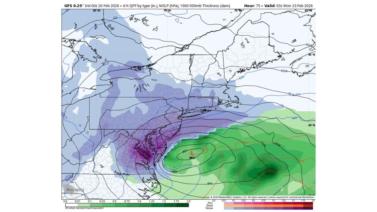
On the forecast map provided (GFS 0.25° guidance valid early Monday), a strengthening coastal low is shown offshore with broad precipitation rotating back toward the Mid-Atlantic and southern New England. That kind of “wraparound” pattern is what can lead to prolonged periods of snow in the colder air north and west of the storm’s center.
Where Snow Looks Most Likely Right Now
Based on the placement of the colder precipitation shield on the map and the discussion provided, the highest confidence for accumulating snow currently favors a wide zone that includes parts of:
- Pennsylvania (especially eastern sections closer to the coast)
- New Jersey (including areas that could see heavier banding if the low tucks closer)
- New York (including the New York City region depending on storm track)
- Connecticut and Rhode Island
- Massachusetts (including the Boston area in a stronger/closer coastal scenario)
Snow also appears possible farther north into portions of Vermont, New Hampshire, and Maine, but the heaviest, most organized banding signal in the materials you provided is focused farther south and closer to the immediate coastal corridor.
I-95 Corridor and Coastal New England: Why This Track Matters
The key forecast question right now is how close the storm center tracks to the coastline—because that determines how far inland the heavier snow bands can reach and whether wind impacts become more significant.
- If the storm stays slightly offshore, snowfall totals could be more limited inland, and the sharp “cutoff” between heavier snow and lighter snow would likely set up closer to the coast.
- If the storm tracks closer and strengthens faster, snowfall rates could increase sharply and heavier banding could expand across major population centers.
That’s why cities specifically mentioned—New York, Boston, and Providence—remain in the spotlight. In a closer, stronger solution, these areas could see a more classic Nor’easter profile: heavier snow bands, reduced visibility, and increasing wind impacts.
What Could Change Next (And Why Forecasts Are Still Tightening Up)
Even with growing confidence in a storm, the final impact footprint can still shift because coastal winter storms are sensitive to small track changes. The biggest “swing factors” based on your forecast text are:
- Storm intensity: How quickly the system deepens (strengthens) as it moves offshore
- Coastal track: Whether the low stays offshore or hugs closer to the coastline
- Band placement: Where the most persistent heavy snow bands set up (often only 30–60 miles wide)
A small track shift can mean the difference between a steady, moderate snowfall and a period of intense banding that piles up snow quickly.
Travel and Safety Prep (Smart Moves Before Sunday)
With the potential for impactful snowfall and the possibility of higher rates in heavier bands, residents across the expected snow zone may want to plan for fast-changing conditions:
- Build flexibility into Sunday and Monday travel plans, especially along major corridors near the coast
- Charge devices and check supplies in case conditions slow commutes or lead to localized outages
- Monitor updated forecasts as details become clearer—especially if you live near I-95 or coastal southern New England, where banding risk can change quickly
As new updates refine the track and strength, the most important details—who gets the heaviest snow and where the sharp edges set up—should come into clearer focus.
If you’re in the Northeast, what are you preparing for this weekend—snow travel, work commutes, or school impacts? Share what you’re seeing in your area, and follow Waldronnews.com for more weather updates as the forecast locks in.