
Ohio Valley and Mid-South Tornado Outbreak Verified as SPC’s 10% Risk Hits Target; Additional Tornadoes Still Being Investigated
MID-SOUTH AND OHIO VALLEY — A significant severe weather event unfolded across portions of the Mid-South and Ohio Valley on February 19, and early verification suggests the Storm Prediction Center’s 10% tornado probability area was well placed. While at least seven tornadoes have been logged so far, forecasters say a couple of additional tornadoes remain unaccounted for as damage surveys continue.
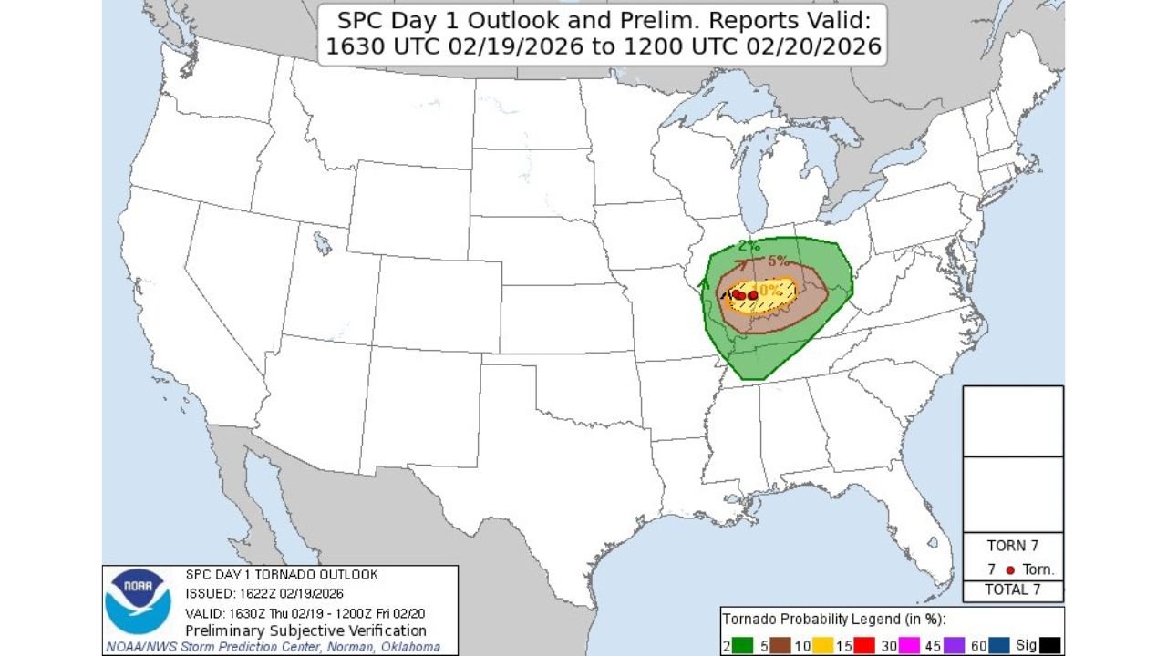
According to the SPC Day 1 Outlook and preliminary reports valid from 1630 UTC February 19 to 1200 UTC February 20, the highest tornado probabilities were centered across parts of Missouri, southern Illinois, western Kentucky, and western Tennessee, with the broader 5% risk extending into portions of Indiana, Arkansas, Mississippi, and Alabama.
SPC 10% Tornado Risk Verified Spatially
The core 10% tornado probability zone — depicted in yellow on the outlook map — aligned closely with where multiple tornado reports were plotted. Red report markers were clustered within that enhanced probability corridor, indicating that the forecast captured the most favorable corridor for tornadic development.
Forecasters noted that “the SPC’s 10% verified very well yesterday, at least spatially,” meaning the geographic placement of the highest tornado threat corresponded closely with where tornadoes actually occurred. Final confirmation of strength and track length will depend on ongoing ground surveys by National Weather Service offices.
At least seven tornadoes have been preliminarily reported within the outlined risk area. However, meteorologists caution that additional brief or rural tornadoes may still be identified in the coming days.
Long-Tracked Warm Front-Rider Helped Predictability
One of the key forecast signals leading into the event was the indication of a long-tracked “warm front-rider” storm system. Models had been consistently highlighting this setup more than 24 hours before the event, increasing confidence in a focused corridor of severe weather.
Warm front-riding supercells often form along and just north of a lifting warm front, where wind shear and instability overlap. In this case, that corridor stretched across parts of southeast Missouri into southern Illinois and western Kentucky, where the highest tornado probabilities were centered.
Because numerical weather models were “pretty good at indicating” this feature more than a day in advance, forecasters were able to better anticipate where the most organized tornadic storms would track.
Tornado Count May Still Rise
While seven tornadoes are currently plotted in preliminary data, officials say “a couple of tornadoes” are still unaccounted for. That means survey teams may uncover additional tracks, especially in rural or wooded areas where damage reports can take longer to verify.
Damage assessments over the next several days will determine:
- Final tornado count
- Exact track lengths
- Intensity ratings (EF-scale)
- Whether any long-track significant tornadoes occurred
It is not uncommon for tornado totals to increase after initial reports as radar data and ground surveys are reconciled.
What This Means Going Forward
This event highlights how improved model guidance and pattern recognition can increase forecast accuracy, especially for focused tornado corridors tied to warm fronts. While not every tornado threat materializes exactly as predicted, the close alignment between the SPC’s 10% outlook and observed reports demonstrates strong spatial forecasting performance.
Residents across the Mid-South and Ohio Valley are reminded that even a 10% tornado probability represents a meaningful threat — particularly when embedded within a favorable shear environment.
More updates are expected once damage surveys are completed and final tornado ratings are assigned.
Stay with Waldronnews.com for continuing coverage and verified updates as additional details become available.