
High-Impact Nor’easter to Slam Maryland Through Maine With Blizzard Conditions and 12–20+ Inches Possible in Philadelphia, NYC and Boston
EAST COAST — A powerful, high-impact nor’easter is expected to develop along the East Coast Sunday before rapidly intensifying as it moves northward into early next week. Forecasters warn that this system could bring blizzard conditions, damaging winds, and snowfall totals exceeding one foot — with some areas approaching or surpassing 20 inches.
The storm is being driven by a potent upper-level trough pivoting through the eastern United States. As energy consolidates offshore, surface low pressure is expected to strengthen quickly along the coastline, a classic setup for a major Northeast winter storm.
Major to Extreme Impacts From Maryland to Maine
Impact guidance shows a corridor of major to extreme winter storm impacts stretching from:
- Maryland and Washington, D.C.
- Delaware and New Jersey
- Philadelphia
- New York City
- Long Island
- Connecticut including Hartford and New Haven
- Rhode Island including Providence
- Boston and eastern Massachusetts
- Coastal portions of New Hampshire and Maine
The most intense impacts are concentrated along the I-95 corridor and immediate coastal communities.
Extreme impact zones suggest:
- Dangerous or impossible travel
- Widespread infrastructure disruptions
- Potential power outages
- Hazardous coastal conditions
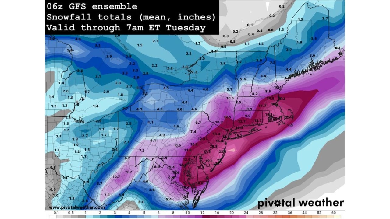
Snowfall Totals: Over a Foot Likely in Core Areas
Ensemble snowfall projections valid through early Tuesday morning show a broad swath of double-digit totals.
Projected mean snowfall amounts include:
- Washington, D.C. and Baltimore: 8–12 inches, locally higher
- Philadelphia: 10–15 inches possible
- New York City: 12–18 inches likely in many areas
- Long Island: 14–20+ inches in parts
- Hartford and Providence: 10–16 inches
- Boston: 12–18 inches, with localized higher totals possible
Some model solutions show pockets approaching 20 inches or more, especially across portions of coastal New Jersey, Long Island, and southern New England where heavy snow banding could persist.
Blizzard Conditions Possible
Strong winds will accompany the heavy snowfall as the low pressure system “bombs out” offshore. Rapid pressure drops will tighten gradients, potentially producing:
- Wind gusts exceeding 40–50 mph near the coast
- Blowing and drifting snow
- Whiteout conditions during peak snowfall
- Increased risk of scattered to widespread power outages
Blizzard conditions are possible where heavy snow combines with sustained winds above 35 mph and sharply reduced visibility.
Coastal Flooding Risk
With the storm strengthening just offshore, onshore flow may lead to coastal flooding concerns, particularly during high tide cycles. Shoreline communities from New Jersey through eastern Massachusetts should monitor local advisories closely.
Timeline
Snow is expected to overspread the Mid-Atlantic Sunday, intensify overnight, and continue through Monday before tapering from south to north into early Tuesday morning.
The heaviest snow bands will likely shift northward through:
- Maryland and Delaware Sunday
- New Jersey and Pennsylvania Sunday night
- New York City and southern New England overnight into Monday
- Eastern Massachusetts and coastal Maine Monday
Bottom Line
A significant, high-impact nor’easter is expected to bring blizzard conditions, damaging winds, and widespread snowfall totals exceeding a foot from Maryland to Maine. Cities including Philadelphia, New York City, and Boston are positioned for potentially major disruptions.
Residents across the Northeast should finalize preparations, avoid unnecessary travel during peak storm conditions, and closely monitor official warnings.
Stay with Waldronnews.com for continuing updates as this major winter storm unfolds.