
Arkansas Weather Whiplash: From Near 80 Degrees Wednesday to Possible Snowflakes and Slushy Grass by Thursday Afternoon
ARKANSAS — After soaring to near and even above 80 degrees on Wednesday, parts of the region could be staring at a stunning turnaround by Thursday, with rain potentially mixing with or changing to wet snow as a powerful cold front barrels through the state.
According to the latest forecast information, this dramatic shift will unfold in less than 24 hours — a classic case of springtime weather whiplash across Arkansas and the surrounding region.
From Spring Warmth to a Sharp Cold Front
Wednesday’s warmth has pushed temperatures close to — and in some locations above — the 80-degree mark. But that unseasonably warm air won’t stick around for long.
A strong cold front is expected to sweep through late Wednesday night, triggering a sharp temperature drop. By Thursday, ground-level temperatures are forecast to fall into the 40s, with some areas possibly dipping into the 30s.
While surface readings may hover just above freezing, conditions higher up in the atmosphere are expected to cool much more rapidly. That upper-level cold air could be enough to flip rain showers over to snow from late Thursday morning into the mid-afternoon hours.
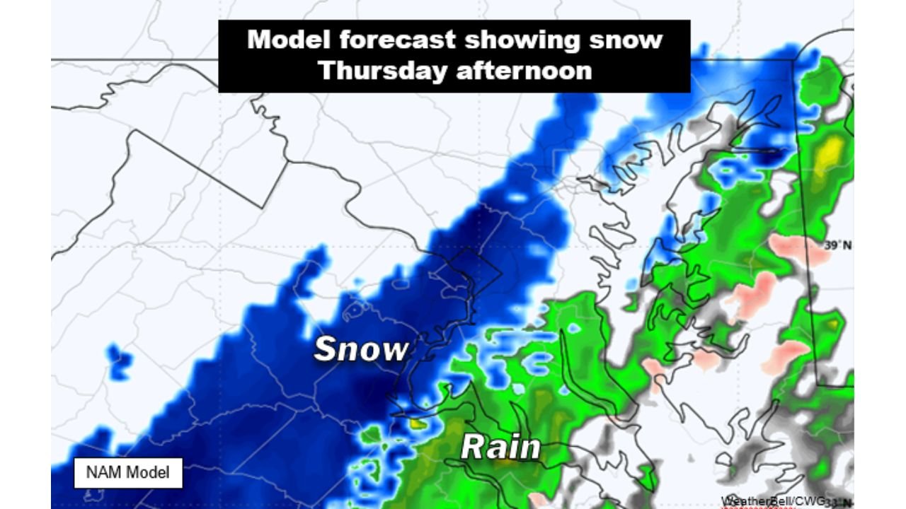
Model Guidance Shows Snow Potential
Forecast modeling for Thursday afternoon shows a swath of snow stretching across parts of the region, with rain continuing farther southeast.
The model depiction highlights a transition zone — where cold air deepens enough to support snow — while areas closer to the warmer sector remain primarily rain. This type of setup often results in mixed precipitation, especially when surface temperatures remain marginal.
For Arkansas, this means that while widespread accumulation is not guaranteed, bursts of wet snow could mix in during heavier showers, particularly if temperatures briefly cool enough during the peak of precipitation.
Why Snow Is Possible After 80 Degrees
It may seem almost impossible to go from two straight days near or above 80 degrees to snowflakes in the air — but it can happen this time of year.
The key lies in the strength of the cold front and the depth of cold air aloft. Even if temperatures at ground level stay above freezing, colder air several thousand feet up can allow snow to form. As flakes fall, they may partially melt on the way down — turning into a rain-snow mix — or survive as wet snow if the air column cools sufficiently.
However, because ground temperatures will still be relatively warm after recent heat, much of any snow that falls could melt on contact with pavement.
Slushy Grass Not Out of the Question
If snow becomes steady enough for a brief period, some areas could see minor slushy accumulation on grassy or elevated surfaces.
Forecasters caution that while road impacts are unlikely given above-freezing ground temperatures, visibility reductions and bursts of heavy wet snow cannot be ruled out during the late morning to mid-afternoon window Thursday.
This kind of rapid temperature swing underscores how volatile early spring weather can be across Arkansas — where summerlike warmth and wintry flakes can occur within a day of each other.
Residents are encouraged to monitor updated forecasts through Thursday as the exact placement of the rain-to-snow line may shift slightly depending on how quickly colder air moves in.
Stay with WaldronNews.com for continuing updates on this fast-changing Arkansas weather pattern.