
Arkansas, Tennessee, Mississippi, Indiana and Carolinas Face Two-Day Severe Weather Threat as Storm System Pushes From Midwest to East Coast
UNITED STATES — A developing storm system is expected to bring two consecutive days of severe weather risk across large portions of the United States, with storms forecast to impact the Mid-South and Midwest on Sunday before shifting toward the Southeast and Mid-Atlantic on Monday.
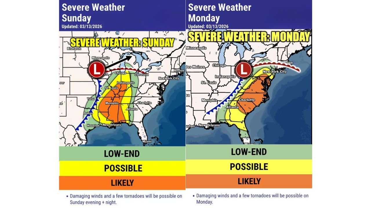
Forecast outlook maps indicate the possibility of damaging winds and isolated tornadoes, with the most active storm zones stretching from Arkansas and Mississippi through Tennessee, Kentucky and Indiana on Sunday, before the threat moves toward the Carolinas and Mid-Atlantic on Monday.
Meteorologists say the evolving system could produce multiple rounds of strong thunderstorms along a powerful cold front, potentially affecting millions of residents across the eastern half of the country.
Sunday Severe Storm Risk Targets Arkansas, Mississippi, Tennessee and Indiana
The first round of storms is expected to develop Sunday as a strong storm system organizes across the central United States.
Severe thunderstorms may develop across a corridor that includes:
- Arkansas
- Mississippi
- Tennessee
- Kentucky
- Indiana
- Parts of Missouri and Illinois
Major cities that could see storms Sunday include:
- Memphis, Tennessee
- Little Rock, Arkansas
- St. Louis, Missouri
- Indianapolis, Indiana
- Atlanta, Georgia
Forecasters say storms Sunday evening and overnight may bring damaging wind gusts and a few tornadoes, particularly where thunderstorms organize along the advancing cold front.
The system is expected to intensify as it moves northeast toward the Great Lakes.
Strong Cold Front Expected to Drive Storm Development
The severe weather threat is being fueled by a deepening low-pressure system moving across the Midwest, which will draw warm and humid air northward from the Gulf of Mexico.
At the same time, a powerful cold front sweeping eastward will provide the lifting mechanism needed for thunderstorms to develop.
This setup often produces long lines of thunderstorms capable of widespread damaging winds, especially when storms organize into squall lines.
Monday Storm Threat Shifts Toward Southeast and East Coast
By Monday, the storm system will move eastward, pushing the severe weather threat into the Southeast and parts of the Mid-Atlantic.
Areas that could experience storms Monday include:
- Georgia
- South Carolina
- North Carolina
- Virginia
- Parts of the Mid-Atlantic region
Cities potentially affected Monday include:
- Atlanta, Georgia
- Charlotte, North Carolina
- Raleigh, North Carolina
- Richmond, Virginia
- Washington, D.C.
As the cold front advances, thunderstorms may redevelop along the boundary, producing damaging winds and isolated tornadoes across parts of the Southeast.
Damaging Winds Expected to Be the Primary Hazard
Across both days of the event, meteorologists say strong straight-line winds will likely be the most widespread threat.
Thunderstorms along the front may produce gusts strong enough to:
- Down trees and power lines
- Cause scattered power outages
- Damage buildings and structures
- Create hazardous travel conditions
Localized tornadoes could also develop within stronger storm cells or rotating segments of thunderstorm lines.
Forecast Confidence Still Developing
Meteorologists emphasize that these outlook maps represent long-range guidance for potential impactful weather, meaning the exact placement and intensity of storms could change as the event approaches.
Small shifts in the track of the storm system or the timing of the cold front could move the areas of greatest severe weather risk north or south.
However, current forecasts suggest the central United States and parts of the Southeast should prepare for a potentially active severe weather period Sunday and Monday.
Residents Urged to Stay Alert Through the Weekend
Emergency officials recommend that residents across the affected regions monitor weather updates closely and prepare for possible severe weather.
Important safety steps include:
- Keeping weather alerts enabled on smartphones
- Monitoring local forecasts and weather apps
- Identifying safe shelter locations inside homes
- Preparing for possible power outages
Severe storms can develop rapidly, and conditions may change quickly as the system moves across the country.
Stay with WaldronNews for continuing updates as meteorologists track this developing two-day severe weather threat across the United States.