
Maryland, Washington DC, and Chesapeake Bay Under Urgent Storm Warnings as 60 MPH Winds and Waterspout Threats Sweep Through Region
MARYLAND — A fast-moving and dangerous line of severe thunderstorms pushed across the Mid-Atlantic Monday night, triggering multiple warnings across Washington DC, Baltimore, Annapolis, and surrounding counties as powerful winds and marine hazards rapidly intensified.
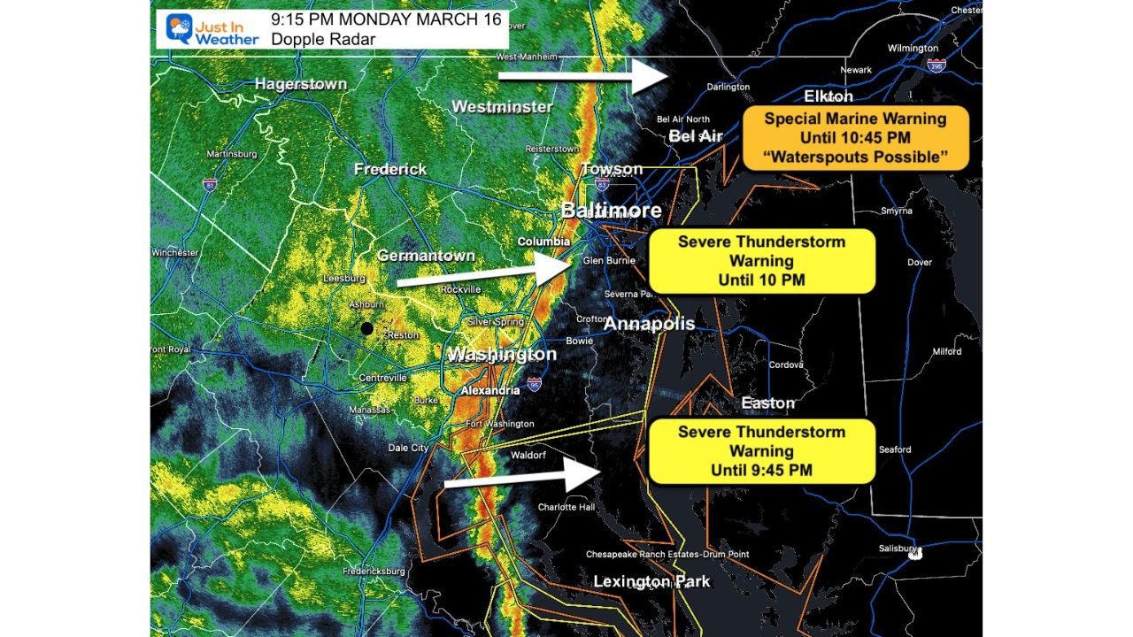
Radar imagery and warning updates show a well-defined storm line racing east across the Potomac River, bringing damaging wind gusts, heavy rain, and the potential for isolated severe impacts.
Severe Thunderstorm Warnings Issued Across Major Cities
As of the late evening update:
- Washington DC, Baltimore, and Annapolis were placed under a Severe Thunderstorm Warning until 10 PM
- Southern Maryland remained under warning until approximately 9:45 PM
- The storm line was actively crossing the Potomac River and pushing toward central and eastern Maryland
Communities including Prince George’s County, Carroll County, northern Baltimore County, Harford County, and Cecil County were all in the path of the advancing storms.
Damaging Winds Up to 60 MPH the Primary Threat
Meteorologists emphasized that the biggest concern with this system is strong straight-line winds, with gusts reaching up to:
- 60 miles per hour in the strongest cells
Unlike typical severe storms, this system has shown:
- Limited lightning activity
- A more linear, fast-moving structure
- Higher emphasis on wind damage potential
This setup increases the risk of:
- Downed trees and power lines
- Localized power outages
- Hazardous travel conditions during the evening hours
Storm Line Intensifying Near Washington DC
The radar snapshot shows the most intense segment of the line:
- Passing directly through Washington DC and moving into Prince George’s County
- Strengthening as it approached the Baltimore metro area
- Expanding northward toward Towson, Bel Air, and Elkton
Forecasters described the storm as “exceptionally strong” in and around the DC metro during its peak passage.
Chesapeake Bay Facing Marine Threat Including Waterspouts
In addition to land-based warnings, a Special Marine Warning was issued for the Chesapeake Bay through 10:45 PM, highlighting:
- Potential for waterspouts
- Sudden wind gusts over open water
- Dangerous boating conditions
Marine zones near Annapolis, Easton, and surrounding Bay waters were particularly at risk as the storm line crossed into the region.
Timeline of Impact Across the Region
The progression of the storm line indicates:
- Washington DC and nearby suburbs: Impacted first during the evening
- Baltimore metro: Shortly after, with strong wind potential
- Northeastern Maryland (Harford and Cecil Counties): Next in line within the hour
This rapid movement means conditions can deteriorate quickly with little warning.
What Residents Should Expect
Residents across Maryland and the DC region should be prepared for:
- Sudden bursts of heavy rain
- Strong, damaging wind gusts
- Brief but intense storm conditions lasting 15–30 minutes per location
Even outside of official warning zones, the broader storm line remains capable of producing hazardous weather conditions.
Bottom Line
A powerful line of severe thunderstorms is sweeping across Washington DC, Baltimore, Annapolis, and the Chesapeake Bay region, bringing:
- Wind gusts up to 60 MPH
- Multiple active Severe Thunderstorm Warnings
- Marine hazards including possible waterspouts
With storms moving quickly and intensifying in places, residents are urged to stay alert and take precautions as conditions continue to evolve through the night.
Stay with WaldronNews.com for real-time updates as this severe weather event continues to move across Maryland and the Mid-Atlantic.