
After Weeks of Storms From Feb 15 to Mar 15, Quiet Pattern Takes Over Late March as Early April Signals Fresh Severe Risk Across Arkansas, Texas and Midwest
ARKANSAS — After an active stretch of storms delivered widespread rain, drought relief, and severe weather across the Plains and Midwest from mid-February through mid-March, the overall pattern is now calming down across the central United States. However, new extended-range guidance suggests this quiet phase may not last long, with early April already showing signs of another round of active and potentially severe weather.
Active Storm Track From Texas to Midwest Finally Slows Down
From February 15 through March 15, a persistent storm corridor stretched from Texas through Arkansas into the Midwest and Great Lakes, bringing repeated waves of rain and thunderstorms.
This setup led to:
- Noticeable drought improvement across parts of the Plains and Midwest
- Multiple rounds of strong to severe thunderstorms
- Local impacts including damaging winds, hail, and heavy rainfall
Arkansas remained directly in the path of these systems, seeing several rounds of unsettled weather as storms tracked northeast from Texas.
Late March Brings a Temporary Calm Across Central U.S.
Latest model trends now indicate that the pattern is shifting into a quieter phase heading into the second half of March.
This means:
- Fewer organized storm systems moving through the region
- Reduced chances for severe weather
- A more stable atmosphere across Arkansas, Texas, Missouri, Illinois, and nearby states
This break is linked to weakening upper-level support that previously fueled frequent storm development.
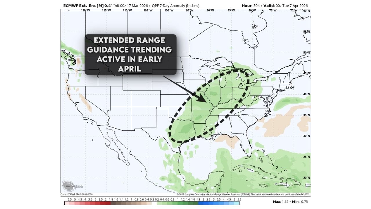
Extended Range Guidance Points to Early April Comeback
Despite the current lull, extended-range ensemble guidance is already signaling a return to a more active pattern in early April.
Forecast anomaly data shows increasing precipitation signals across a broad corridor extending from:
- Southern Texas and the Gulf Coast
- Through Arkansas and the Lower Mississippi Valley
- Into the Midwest and Great Lakes
This indicates the likely return of a classic spring storm track, where systems move from southwest to northeast across the country.
Arkansas and Surrounding States Likely Back in the Impact Zone
If this pattern develops as projected, Arkansas will once again be positioned in a key zone for storm activity.
Key ingredients expected to return include:
- Increasing moisture flow from the Gulf of Mexico
- Rising atmospheric instability
- Favorable wind patterns supporting organized storms
This combination often supports severe thunderstorms, including risks for:
- Damaging winds
- Large hail
- Possible tornado activity
Neighboring states such as Texas, Louisiana, Mississippi, Missouri, and Illinois could also experience renewed storm threats.
Quiet Phase Now, But Severe Season Far From Over
The ongoing calm should be viewed as a temporary pause rather than an end to active weather across the region.
- Late March → Quieter and more stable conditions
- Early April → Potential return of storms and severe weather risk
This type of transition is typical during spring, when patterns can quickly shift back toward active conditions.
What to Watch in the Coming Weeks
For now, residents across Arkansas and surrounding regions can expect a break from frequent storms. However, attention should begin shifting toward early April as signals for renewed activity continue to strengthen.
Weather conditions during this time could once again become favorable for widespread thunderstorms across the Plains and Midwest.
Stay with WaldronNews.com for the latest updates as the early April storm pattern becomes clearer.