
Florida Weather Alert Miami, Orlando, Tampa and Jacksonville Brace for Midweek Rain Surge as Front Stalls Across Peninsula
FLORIDA — A developing weather setup is now pointing toward a significant increase in rainfall across the Florida Peninsula, with cities including Miami, Orlando, Tampa, and Jacksonville expected to see rounds of heavier rain during the middle of the upcoming week.
Forecast guidance shows a frontal boundary pushing south early in the week before slowing down and stalling across Florida, creating a setup favorable for lingering showers and locally heavier rainfall totals.
Frontal Boundary Moves In Then Slows Down
The evolving pattern suggests:
- A cold front drops south into Florida early in the week
- Instead of quickly moving through, the boundary slows and stalls across the peninsula
- This allows moisture to pool along the front, increasing rainfall potential
This type of setup is often associated with longer-lasting rain events rather than quick-moving storms.
Heavier Rain Potential Increasing Across Key Cities
Areas expected to see the greatest impacts include:
- Miami and South Florida
- Fort Lauderdale and West Palm Beach
- Orlando and Central Florida
- Tampa and the Gulf Coast
- Jacksonville and Northeast Florida
Across these regions:
- Multiple rounds of showers and thunderstorms are possible
- Rainfall could become locally heavy at times
- Some areas may experience repeated bands of rain over the same locations
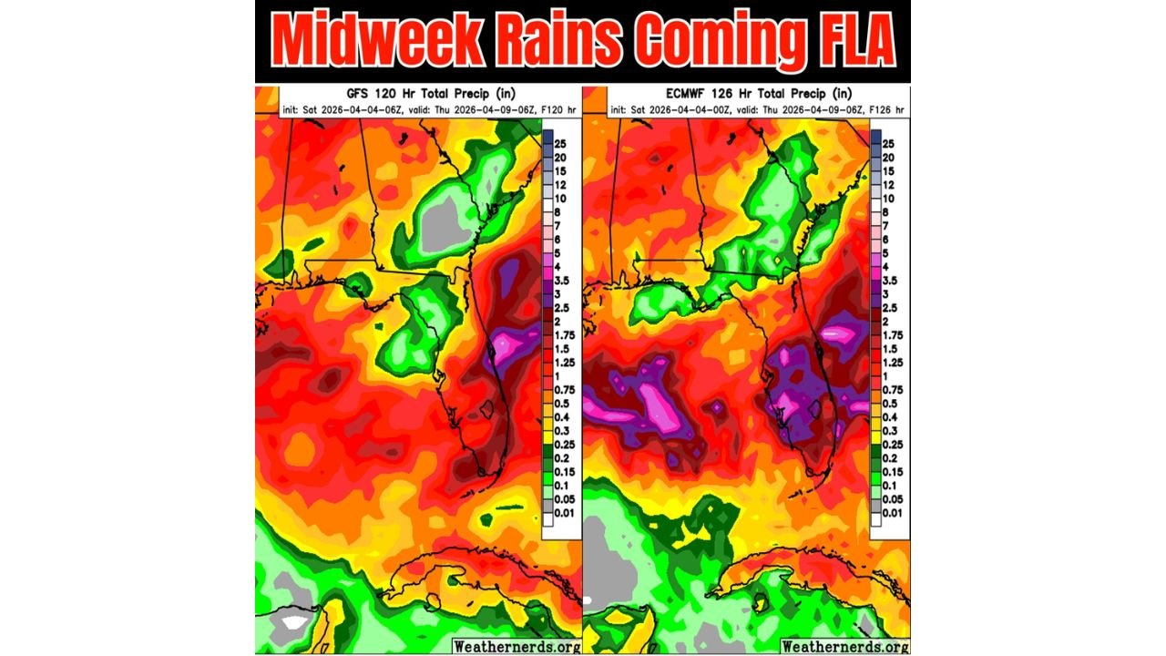
Forecast Models Showing Strong Rain Signal
Weather model comparisons indicate:
- The European model (ECMWF) is showing a more aggressive rainfall scenario
- The GFS model also supports rain but appears less intense
- Both models agree on the key point: Florida will see a noticeable increase in rainfall midweek
This agreement boosts confidence that wet conditions are likely, even if exact totals vary.
Good News for Drought Conditions
This pattern could bring some benefits:
- Much-needed rainfall across parts of Florida
- Potential short-term drought relief
- Improvement in soil moisture levels, especially ahead of the rainy season
However, because Florida is not yet in its peak rainy season, the rainfall may be:
- Unevenly distributed
- Not enough to fully eliminate longer-term dryness
What Residents Should Expect
People across Florida should prepare for:
- Wet conditions developing midweek
- Periods of moderate to heavy rain
- Possible ponding on roads and reduced visibility during heavier showers
- Slower-moving weather systems that may extend rainy conditions over multiple days
Final Outlook
Florida is entering a more active and moisture-rich pattern, with a stalling front likely to bring rounds of rain across Miami, Orlando, Tampa, and Jacksonville through the middle of the week.
This setup will be important to watch as it develops, especially for areas that could see repeated rainfall and localized higher totals.
Stay with WaldronNews.com for continued updates as this midweek rain event unfolds across Florida.