
Virginia, Maryland, DC and Carolinas Told to Watch Cooling Nights and Dry Stretch as New Outlook Signals Growing Drought Risk
WASHINGTON, DC — A noticeable shift in weather conditions is setting up across the Mid-Atlantic and Southeast, where a combination of cooler nights, breezy conditions, and an extended dry stretch is beginning to raise growing drought concerns across multiple states.
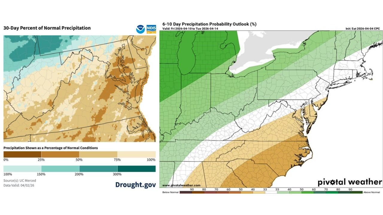
Forecast data shows that while conditions will feel pleasant and cooler through midweek, the bigger concern lies in what’s missing — meaningful rainfall across an already drying region.
Cooler Nights Drop Temperatures Near 40 Degrees
The short-term pattern begins with a cool and clearing setup, especially overnight, where temperatures are expected to fall to around 40°F in several areas, including:
- Virginia
- Maryland
- Washington, DC
- Parts of North Carolina
This cooler air mass is being driven by:
- Clear skies allowing heat to escape overnight
- A dry atmosphere limiting cloud cover
- Light winds contributing to efficient cooling conditions
While not a widespread freeze, these conditions will feel noticeably cooler than recent days.
Sunny, Breezy and Cooler Conditions Through Midweek
Daytime conditions will remain sunny and breezy, with temperatures staying on the cooler side of normal into midweek.
Key features of this pattern include:
- Abundant sunshine across the region
- Low humidity levels
- A steady breeze reinforcing the cooler feel
This creates comfortable weather overall, but it also signals a lack of storm systems and rainfall opportunities.
30-Day Data Shows Region Already Running Dry
Looking at recent trends, precipitation data over the past 30 days shows that much of the region is already experiencing below-normal rainfall, especially across:
- Virginia
- Maryland
- Delaware
- North Carolina
Large areas are showing significant rainfall deficits, with some locations receiving only:
- 25% to 75% of normal precipitation
This indicates that the region has already entered a developing dry phase, even before the upcoming stretch of dry weather.
Rain Chances Stay Limited in the Next 6 to 10 Days
Extended outlooks further reinforce the concern, showing that below-normal precipitation is likely to continue across:
- Mid-Atlantic states
- Carolinas
- Surrounding Southeast regions
Forecast probabilities highlight:
- A strong signal for suppressed rainfall
- Storm systems tracking north of the region
- Limited opportunities for organized rain events
This means the region is likely to remain largely dry through at least mid-April.
Dry Stretch Could Accelerate Drought Development
With cooler air early in the week transitioning into continued dry conditions, the region faces a setup that can quickly lead to:
- Soil moisture depletion
- Increased stress on vegetation and crops
- Expansion of abnormally dry and drought conditions
Even though temperatures are not excessively hot yet, the lack of rainfall combined with persistent dry air is enough to begin accelerating drought risk.
Key Areas Most at Risk
The areas most vulnerable to worsening dry conditions include:
- Central and eastern Virginia
- Maryland and DC metro area
- Delaware
- Eastern North Carolina
These regions are already showing precipitation deficits and limited upcoming rainfall, placing them directly in the growing drought concern zone.
Why This Pattern Matters Right Now
This pattern may seem mild on the surface due to comfortable temperatures and clear skies, but it represents a classic early-stage drought setup, where:
- Rainfall quietly disappears for extended periods
- Soil moisture declines without immediate notice
- Conditions worsen gradually before becoming more obvious
Without a shift in the pattern, the region could enter late April with increasing drought pressure already in place.
What Residents Should Watch Going Forward
Residents across the Mid-Atlantic and nearby regions should monitor:
- Any changes in rainfall forecasts over the next 1–2 weeks
- Updates on drought conditions and soil moisture levels
- Signs of extended dry patterns continuing into late spring
Even a few rounds of steady rain could help stabilize conditions, but for now, the outlook remains firmly on the dry side.
Stay with WaldronNews.com for continued updates as this cool but increasingly dry weather pattern develops across Virginia, Maryland, Washington, DC, and the Carolinas.