
Kansas, Oklahoma, Missouri and Iowa Told to Watch April 12–13 Severe Storm Setup as New Pattern Signals Multi Day Plains Risk
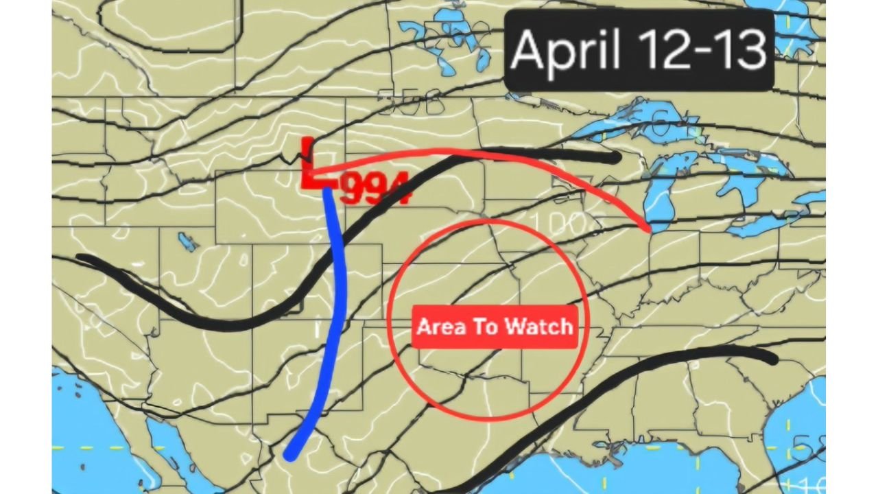
UNITED STATES — A developing weather pattern is beginning to raise attention across the Central Plains and Midwest, where new forecast data is signaling a potential multi-day severe weather setup around April 12–13, with several states now marked as a key area to watch.
While details are still evolving, early indications point toward a classic Plains storm pattern, which could bring multiple rounds of severe weather across the region.
Central Plains Identified as Primary Area to Watch
The latest upper-level pattern highlights a focused zone across:
- Kansas
- Oklahoma
- Missouri
- Iowa
- Parts of Nebraska and Arkansas
This region has been clearly marked as an “area to watch”, suggesting that atmospheric conditions may align for organized severe storm development.
This zone sits directly within a favorable corridor for storm initiation and movement, especially when larger systems begin organizing across the Plains.
Developing Low Pressure System Could Drive Storm Activity
Forecast data shows a strengthening low-pressure system forming across the central United States, with key features including:
- A deepening surface low near the Central Plains
- A dryline setup extending through western Texas and Oklahoma
- Strong upper-level energy moving across the region
These ingredients are critical because they support:
- Storm development along boundaries
- Increasing wind shear and instability
- The potential for organized severe weather outbreaks
Multi Day Severe Pattern Possible
Unlike a single-day event, this setup is showing signs of becoming a multi-day severe weather sequence, which increases overall risk.
This means:
- Storms could develop on consecutive days
- Multiple states may be impacted over time
- Conditions may evolve and shift eastward into the Midwest
Multi-day patterns are especially important because they:
- Extend the duration of risk
- Increase the likelihood of repeated impacts in some areas
Classic Plains Setup Signals Elevated Risk Potential
Early signals suggest this could resemble a classic Plains severe weather setup, which typically includes:
- Warm, moist air surging northward from the Gulf
- A sharp dryline acting as a trigger for storms
- Strong jet stream support enhancing storm organization
When these elements come together, they can support:
- Supercell thunderstorms
- Potential for large hail, damaging winds, and tornadoes
- More organized and widespread severe weather activity
Why This Pattern Is Being Watched Closely
Although exact impacts are not yet defined, the reason this setup is gaining attention is due to the overall pattern alignment, which is often associated with:
- Higher-end severe weather potential
- More organized storm structures
- Greater forecast confidence as the event approaches
Even at this early stage, the presence of a defined storm track corridor and upper-level support makes this a situation that cannot be ignored.
Areas That Should Stay Alert
The primary regions to monitor include:
- Kansas and Oklahoma
- Missouri and Iowa
- Parts of Nebraska and Arkansas
These areas fall directly within the early projected risk zone, where storms are most likely to initiate and intensify.
What Residents Should Watch Going Forward
As the setup develops, residents should keep an eye on:
- Updates to severe weather outlooks and risk areas
- Changes in storm timing and intensity forecasts
- Any expansion of the risk into the Midwest or Southern Plains
Forecast details will become clearer in the coming days, but early signals suggest a potentially active and impactful period of severe weather.
Why Early Awareness Matters
Severe weather patterns like this can evolve quickly, especially when:
- Multiple atmospheric ingredients begin aligning
- Storm systems organize over large areas
- Conditions support long-lived thunderstorms
Being aware early allows communities to:
- Prepare for possible severe weather alerts
- Monitor changing forecasts closely
- Stay ready for rapidly developing conditions
Stay with WaldronNews.com for continued updates as this developing April 12–13 severe weather setup across Kansas, Oklahoma, Missouri, and Iowa continues to evolve.