
Missouri, Kansas and Northern Counties Told to Watch Monday Night Snow Chance as New Forecast Signals Frost and Light Accumulation Risk
MISSOURI — A changing weather pattern is prompting communities across Missouri, eastern Kansas, and nearby northern regions to stay alert, as a new forecast highlights the potential for light snow and freezing conditions returning Monday night into Tuesday morning.
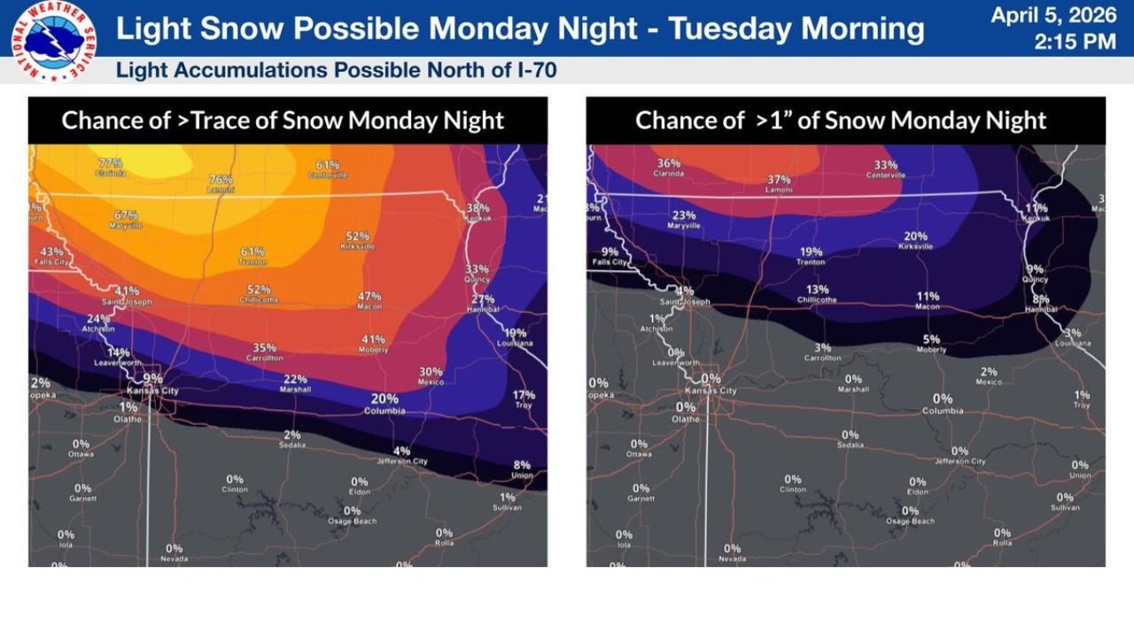
While this will not be a major winter storm, the combination of cold temperatures and light snowfall could still create localized impacts, especially across areas north of key highways.
Light Snow Expected Primarily North of I-70
Forecast data clearly shows that the highest probability for snowfall will remain north of Interstate 70, including areas such as:
- Northern Missouri
- Northern Kansas City metro outskirts
- Central and northeastern Missouri regions
Probability maps indicate:
- 40% to 70% chance of at least a trace of snow in northern counties
- Lower chances, dropping to 20% or less, as you move south toward central Missouri
This means many locations north of I-70 could see at least some snowflakes Monday night, even if accumulations remain limited.
Higher Accumulation Chances Focus Near Highway 36 Corridor
For those looking at actual accumulation potential, the best chances for measurable snow (1 inch or more) are expected further north, particularly near and north of Highway 36.
Key details include:
- 20% to 35% chance of 1 inch or more snowfall in far northern Missouri
- Rapid drop-off in accumulation chances moving south
- Areas south of I-70 expected to see little to no accumulation
This confirms that snowfall impacts will be highly location-dependent, with northern counties seeing the greatest potential.
Temperatures Near or Below Freezing Raise Frost Concerns
In addition to snow chances, temperatures are expected to fall to around or below freezing Monday night, creating conditions favorable for:
- Widespread frost development
- Possible freeze conditions in some areas
- Increased risk to early vegetation and sensitive plants
This is especially important because recent mild conditions may have encouraged early plant growth, making vegetation more vulnerable.
Timing of the System
The current timing for this setup is:
- Monday evening: Temperatures begin dropping with increasing cloud cover
- Late Monday night: Best window for light snow development north of I-70
- Early Tuesday morning: Snow tapers off with lingering cold conditions
Any snow that does fall is expected to be short-lived and light, but could still create slick spots in localized areas, especially on elevated surfaces.
Why This Setup Matters Despite Light Snow Totals
Even though snowfall amounts are expected to remain relatively low, this pattern is important because it combines:
- Cold temperatures
- Light precipitation
- Overnight timing
This increases the risk of:
- Patchy icy conditions
- Frost damage to plants and agriculture
- Brief travel impacts in northern counties
Key Areas to Watch Closely
The most impacted regions include:
- Northern Missouri (especially near Highway 36)
- Areas north of I-70
- Northern sections of the Kansas City region
These areas sit within the highest probability zone for both snow and freezing conditions.
What Residents Should Do Now
Residents across Missouri and nearby areas should:
- Prepare for cold overnight temperatures
- Protect sensitive plants and outdoor vegetation
- Stay alert for localized slick spots Tuesday morning
Even minor snowfall combined with freezing temperatures can create unexpected hazards, especially during early morning travel.
Stay with WaldronNews.com for continued updates as this Monday night snow and frost setup across Missouri and Kansas develops.