
Florida East Coast Communities Told to Watch Soaking Rain Event as New Forecast Shows 5+ Inches Possible This Week
FLORIDA — Communities along the Florida East Coast are being urged to stay alert, as a new rainfall forecast highlights a significant soaking rain event developing this week, with over 5 inches of rain possible in several areas.
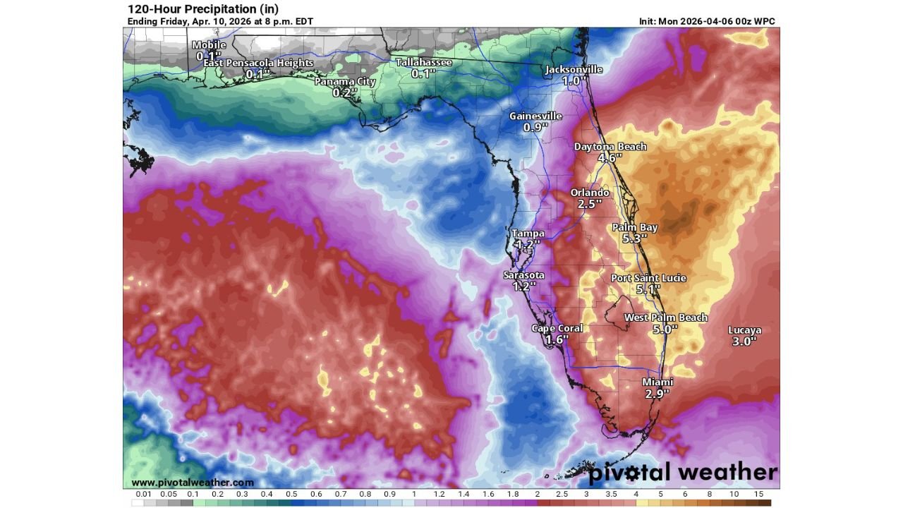
The latest data shows a focused corridor of heavy rainfall stretching from Central Florida down through South Florida, raising concerns for localized flooding and prolonged wet conditions.
Heavy Rain Focused Along Space Coast and Treasure Coast
The most intense rainfall is expected along the eastern side of the Florida Peninsula, particularly across:
- Daytona Beach (around 4.5+ inches)
- Palm Bay (around 5.3 inches)
- Port St. Lucie (around 5.1 inches)
- West Palm Beach (near 5 inches)
These areas, including the Space Coast and Treasure Coast, sit directly within the highest rainfall zone, where totals could exceed 5 inches over the 120-hour period.
This setup indicates a prolonged and soaking rainfall pattern, rather than a quick-moving storm.
Central Florida Also Sees Significant Rainfall Totals
Further inland, areas such as:
- Orlando (around 2.5 inches)
- Gainesville (near 1 inch)
will also see moderate rainfall, though totals decrease compared to the coastal zones.
Meanwhile, Tampa and the Gulf Coast are expected to receive:
- Around 1 to 1.5 inches, significantly lower than the east coast totals
This highlights a sharp east-to-west rainfall gradient, with the heaviest rain staying near the Atlantic side.
South Florida Faces Prolonged Wet Conditions
Across South Florida, including:
- Miami (around 2.5 to 3 inches)
- Cape Coral (around 1.5 inches)
rainfall will still be notable, though slightly less intense than the central east coast.
However, the key concern is the duration of the rainfall, as repeated rounds of rain could lead to:
- Saturated ground conditions
- Increased risk of urban flooding
- Slow drainage in low-lying areas
Why This Rainfall Event Is Significant
This is not just a single storm — it is a multi-day rainfall event, which increases the risk of:
- Accumulating rainfall totals over several days
- Repeated periods of moderate to heavy rain
- Higher chances of flooding due to saturation
The placement of the heaviest rain along the east coast suggests a persistent moisture feed from the Atlantic, keeping conditions active.
Key Risks Residents Should Watch
Residents across the Florida East Coast should be prepared for:
- Localized flooding in urban and low-lying areas
- Ponding of water on roads during heavier rain periods
- Reduced visibility and travel impacts during downpours
The risk is highest in areas expecting 4 to 5+ inches of total rainfall, especially where drainage systems may be overwhelmed.
Areas Most at Risk
The most impacted regions include:
- Daytona Beach and surrounding areas
- Space Coast including Palm Bay
- Treasure Coast including Port St. Lucie
- West Palm Beach and nearby coastal communities
These locations are directly within the core heavy rainfall zone.
What Residents Should Do Now
Residents should:
- Stay updated on local weather alerts and forecasts
- Be cautious of flood-prone roadways
- Prepare for periods of heavy rain over multiple days
Even if rainfall is spread out, the cumulative totals could still create significant impacts.
Why This Pattern Matters Moving Forward
This event highlights a shift toward a wetter pattern along the Florida East Coast, especially compared to other parts of the Southeast that remain relatively dry.
If similar systems continue, the region could see:
- Improved drought conditions in some areas
- But also increased flood risk during heavier events
Stay with WaldronNews.com for continued updates as this developing heavy rain event across Florida’s Space Coast and Treasure Coast unfolds through the week.