
Texas and Oklahoma Severe Weather Alert Issued for April 12 and 13 as Tornado, Hail and Wind Threat Targets Central and Southern Plains
TEXAS AND OKLAHOMA — A developing weekend storm setup is now being closely monitored as severe weather potential builds across the central and southern Plains, with both Sunday (April 12) and Monday (April 13) showing strong signals for impactful storms.
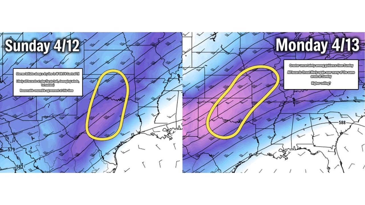
Forecast trends indicate that storms could initiate across western Oklahoma and north-central Texas, with the threat expanding northeast into surrounding states as the system evolves.
Sunday Setup Points to Initial Storm Development
Sunday currently shows the more organized and confident setup, with storms expected to form along a key boundary across:
- Western Oklahoma
- North-central Texas
This region includes areas near:
- Oklahoma City
- Wichita Falls
- Parts of the Red River region
Conditions suggest that all severe hazards could be in play, including:
- Large hail
- Damaging winds
- Tornado potential
The environment appears supportive of storm organization early in the event, increasing the risk of stronger storms during the initial phase.
Monday Brings Expanded but More Uncertain Risk
By Monday, the severe threat is expected to shift and expand northeast, covering a broader portion of the Plains and possibly into nearby regions.
However, forecast confidence becomes more uncertain due to:
- Differences in model guidance
- Questions around storm timing and structure
- Potential changes in atmospheric “cap” strength
Despite this uncertainty, current signals still indicate:
- A continued all-hazards severe weather risk
- Storms affecting many of the same regions impacted Sunday
Why This Two-Day Setup Is Important
The biggest concern with this forecast is the back-to-back nature of the storm threat.
This means:
- Areas impacted Sunday may see renewed storms on Monday
- Atmospheric conditions may remain favorable for multiple storm rounds
- Severe weather could become more widespread if systems organize efficiently
Storm Environment Supports Multiple Hazards
The overall pattern shows:
- Strong upper-level winds
- Increasing instability across Texas and Oklahoma
- Favorable wind shear for storm rotation
This combination raises the potential for:
- Supercell thunderstorms
- Tornado development in isolated areas
- Clusters of storms producing damaging winds
Central and Southern Plains Remain the Focus
The core risk zone currently centers on:
- Texas (especially north and central regions)
- Oklahoma (particularly western and central areas)
From there, storms may track northeast toward:
- Kansas
- Missouri
- Parts of Arkansas
Forecast Still Evolving but Signals Are Strong
While exact details will continue to change, what remains clear is:
- The pattern supports active severe weather conditions across both days
- Sunday currently carries higher confidence
- Monday could bring broader impacts depending on storm evolution
What Residents Should Do Now
With a two-day severe weather window approaching, residents should:
- Stay updated on forecast changes
- Monitor local alerts and warnings
- Prepare for rapidly changing weather conditions
- Review shelter plans in case warnings are issued
A Sign of an Increasingly Active Pattern
This weekend setup is another indication that the Plains are entering a more active severe weather phase, with repeated storm chances becoming more likely through mid-April.
Stay with WaldronNews.com for the latest updates as this developing severe weather threat becomes clearer heading into Sunday and Monday.