
Illinois Missouri Iowa Wisconsin Arkansas Louisiana Texas Oklahoma Severe Weather Alert Issued for Sunday Monday Outbreak
UNITED STATES — A new severe weather alert is now being issued across the Plains and Midwest, as forecast data signals a multi-state outbreak potential developing from Sunday into Monday (April 12–13). After a relatively quiet stretch, conditions are rapidly shifting toward a high-impact severe weather setup spanning Texas to the Great Lakes.
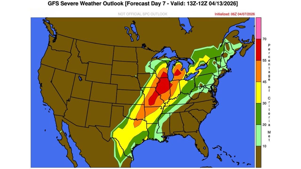
The latest outlook highlights a corridor of increasing storm intensity stretching from Texas and Oklahoma through Arkansas, Missouri, Illinois, Iowa, and into Wisconsin, with expanding risk pushing toward parts of the Midwest and Great Lakes.
Sunday Setup Targets Southern Plains Into Midwest
On Sunday (April 12), storm development is expected to begin across:
- Texas
- Oklahoma
- Arkansas
- Missouri
- Extending north toward Iowa and southern Wisconsin
This phase appears to focus on a long north-south corridor of instability, where storms may organize into:
- Supercells
- Clusters capable of large hail
- Damaging wind events
The environment supports all severe hazards, especially as storms begin to intensify through the afternoon and evening hours.
Monday Escalation Brings Stronger Midwest Threat
By Monday (April 13), the system shifts and intensifies further northeast, bringing a more concentrated severe weather risk into the Midwest and Great Lakes, including:
- Illinois
- Iowa
- Wisconsin
- Surrounding regions
Forecast signals show a stronger and more organized setup, with a broader area of significant severe potential compared to Sunday.
This suggests:
- Increased storm coverage
- Higher intensity storms
- Expanded risk footprint
Core Risk Zone Expanding Northward
The most concerning signal in the data is the expansion of the highest risk zone from the southern Plains into the central Midwest.
Key areas to monitor closely include:
- Eastern Kansas into Missouri
- Much of Illinois and Iowa
- Parts of Wisconsin
These regions may experience the peak of the outbreak, depending on how the system evolves.
All Severe Hazards Possible
Across both days, the setup supports a full spectrum of severe weather threats, including:
- Tornado potential, especially with organized supercells
- Damaging straight-line winds
- Large hail, possibly significant in stronger storms
The combination of instability and wind dynamics suggests that some storms could become long-lived and dangerous.
Rapid Pattern Change After Quiet Period
This outbreak follows a recent lull in severe weather activity, making the transition more notable. The atmosphere is now shifting into a more active spring pattern, with multiple storm systems likely to follow.
Timing Still Being Refined
While confidence is increasing in a Sunday–Monday severe weather event, exact details such as:
- Peak outbreak timing
- Specific storm tracks
- Highest tornado zones
will continue to be refined in the coming days.
Residents Across Multiple States Urged to Prepare
With a multi-day, multi-state event shaping up, residents across the Plains and Midwest should:
- Stay alert for forecast updates
- Review severe weather safety plans
- Ensure warning systems are active
- Identify safe shelter locations
This setup has the potential to produce widespread impacts across several states, not just isolated storms.
A Developing Multi-Day Outbreak to Watch Closely
From Texas and Oklahoma through Arkansas, Missouri, Illinois, Iowa, and Wisconsin, this emerging system represents a significant return of severe weather across the central United States.
Sunday into Monday is now a critical window to watch, as conditions align for a potentially impactful outbreak.
Stay with WaldronNews.com as this situation evolves and more precise threat zones and timing details become available.