
New Seasonal Forecast Shows Ohio Valley States Facing Summer Dryness While Rockies and Southwest Turn Wetter So People Should Stay Alert Early
UNITED STATES — A new long-range summer precipitation outlook tied to strengthening El Niño conditions is raising early concerns across multiple regions, with a clear signal emerging: the Ohio Valley could trend drier while the Rockies and parts of the Southwest lean wetter heading into June, July, and August.
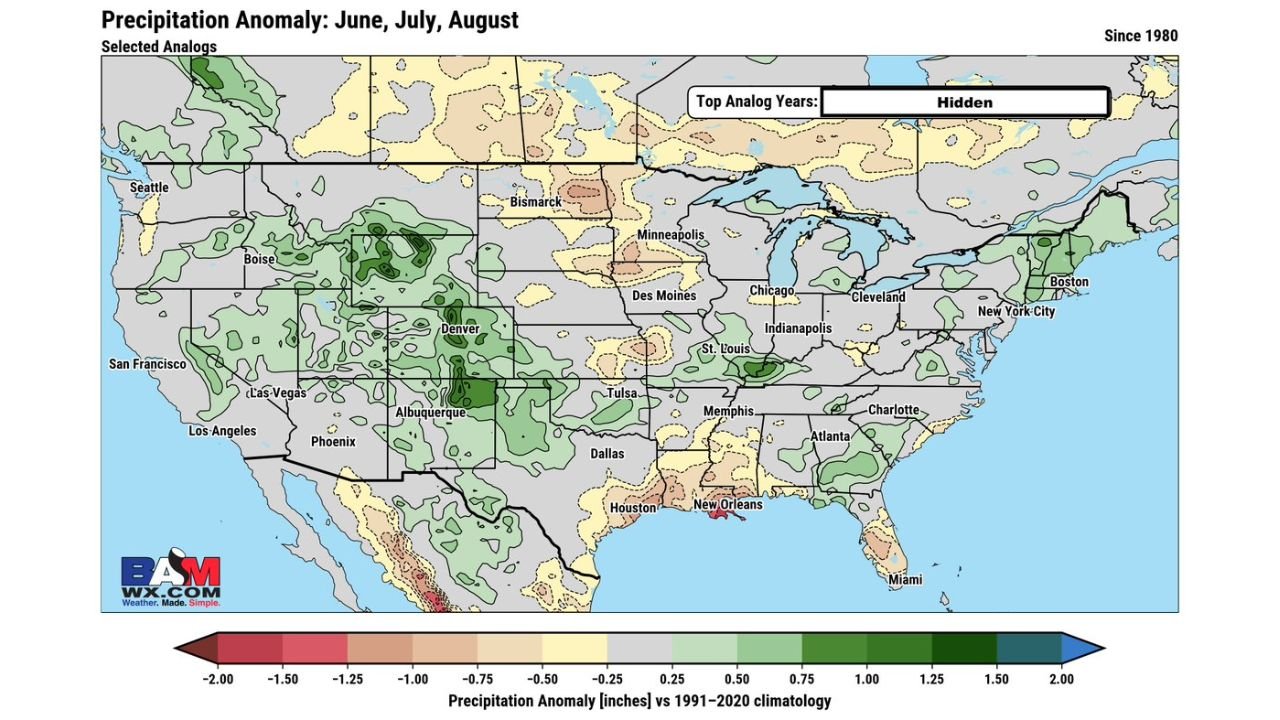
The latest anomaly data highlights how shifting atmospheric patterns may reshape rainfall distribution across the country during peak summer months, potentially impacting agriculture, water supply, and day-to-day weather expectations.
Ohio Valley and Central U.S. Showing Drying Trend
One of the most important takeaways from the data is the increasing likelihood of below-normal precipitation across the Ohio Valley and nearby central regions.
Areas including:
- Illinois
- Indiana
- Ohio
- Kentucky
- Parts of Missouri
are seeing signals of slightly to moderately below-average rainfall, especially as summer progresses.
This aligns with typical El Niño behavior, where storm tracks shift and reduce consistent moisture delivery into this region. If this pattern holds, it could lead to:
- Early-season dryness concerns
- Stress on crops during key growth periods
- Increased heat amplification due to lack of soil moisture
Rockies and Southwest Turning Wetter
In contrast, a strong wet signal is developing across the western interior, especially in:
- Colorado
- New Mexico
- Utah
- Wyoming
- Parts of Arizona
These areas are expected to see above-average precipitation, with some pockets showing significantly wetter-than-normal conditions.
The data suggests:
- Enhanced monsoon-like activity in the Southwest
- Increased thunderstorm frequency in the Rockies
- Potential localized flooding risks in mountainous terrain
This wet pattern could help improve drought conditions in some western zones, but it also raises the risk of uneven rainfall distribution.
Southern Plains and Gulf Coast Mixed Signals
The southern tier presents a more complex picture.
States including:
- Texas
- Louisiana
- Mississippi
- Alabama
are showing mixed to slightly below-normal precipitation trends, especially near the Gulf Coast.
Notably:
- Coastal Texas and Louisiana show drier signals
- Inland areas may see scattered, inconsistent rainfall
This could create a volatile setup where periods of dryness are interrupted by isolated heavy rain events.
Midwest and Great Lakes: Near Normal but Uneven
The Midwest and Great Lakes region, including:
- Michigan
- Wisconsin
- Minnesota
appears closer to near-average precipitation overall, but the distribution is uneven.
Some localized areas show:
- Slight wet pockets
- Nearby dry zones
This suggests that while totals may average out, rainfall could be inconsistent, with some areas benefiting while others fall behind.
Northeast and Southeast Stay Near to Slightly Wet
The Eastern U.S., including:
- New York
- Pennsylvania
- Carolinas
- Georgia
is trending near-normal to slightly above-normal precipitation.
This indicates:
- Regular storm activity may continue
- No strong drought signal at this time
- Periodic rainfall could support stable summer conditions
What This Means Going Forward
This evolving summer pattern highlights a clear regional divide:
- Dry Risk: Ohio Valley and parts of the central U.S.
- Wet Pattern: Rockies and Southwest
- Mixed Signals: Southern Plains and Gulf Coast
- Stable Zones: Northeast and parts of the Southeast
The influence of El Niño appears to be pushing the jet stream farther east, altering storm tracks and redistributing moisture across the country.
Why People Should Watch This Now
This is not just a routine seasonal outlook. The developing pattern could have real impacts on:
- Farming and crop yields
- Water availability
- Heat intensity during peak summer
- Severe weather distribution
Even small deviations in summer rainfall can lead to significant downstream effects, especially in already sensitive regions like the Ohio Valley.
Final Outlook
As summer approaches, this forecast serves as an early signal of how conditions may unfold. While updates are expected, the current trend strongly suggests a drier central corridor and a wetter western interior.
Residents, especially in the Ohio Valley and central states, should begin monitoring updates closely as this pattern evolves.
Stay connected with WaldronNews.com for the latest updates as this summer forecast continues to develop and refine in the coming weeks.