
Central U.S. Placed on Multi Day Weather Alert as Severe Storms and Heavy Rain Target Texas Oklahoma Kansas Missouri and Illinois Through April 14
UNITED STATES — A newly updated hazards outlook is signaling a multi-day stretch of dangerous weather conditions across the central United States, with both severe thunderstorms and heavy rainfall expected from April 10 through April 14.
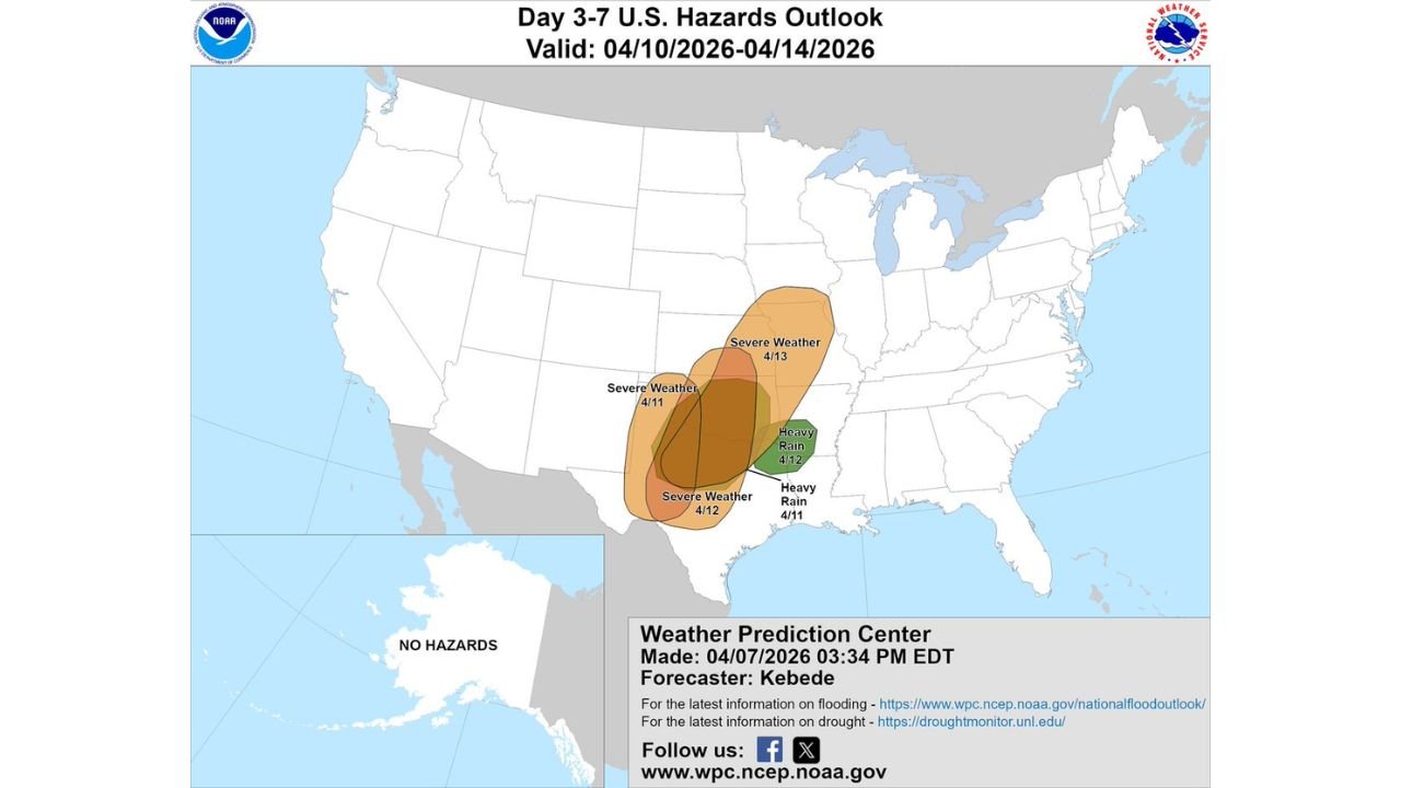
The latest outlook highlights a growing zone of concern stretching from Texas and Oklahoma northward into Kansas, Missouri, and parts of Illinois, where repeated rounds of storms could create both severe weather risks and flooding concerns.
Severe Weather Threat Builds Across the Plains
The core severe weather zone is expected to develop in stages:
- April 11: Initial severe storm potential across parts of the southern Plains
- April 12: Expanding and intensifying risk across Texas and Oklahoma
- April 13: Threat shifting north into Kansas, Missouri, and nearby Midwest areas
This progression suggests a classic Plains-to-Midwest storm track, where storms organize in the south and then track northeast over time.
Areas including Dallas, Oklahoma City, Tulsa, Wichita, Kansas City, and St. Louis could all experience periods of strong to severe storms during this window.
Heavy Rain and Flooding Risk Also Emerging
In addition to severe storms, a heavy rainfall corridor is expected to develop east of the main severe zone, particularly across:
- Arkansas
- Mississippi Valley regions
- Parts of Louisiana and surrounding areas
Repeated rainfall over the same areas could lead to:
- Localized flooding
- Rapid rises in creeks and streams
- Travel disruptions in low-lying areas
This overlapping threat makes this setup more impactful than a typical single-day storm system.
Why This Setup Is Significant
The weather pattern driving this event is highly supportive of prolonged storm activity:
- A persistent trough over the western U.S.
- Strong southerly flow bringing moisture northward from the Gulf
- Increasing instability and wind energy across the Plains
This combination supports:
- Organized thunderstorm clusters
- Supercell development
- Potential for all severe hazards, including hail, damaging winds, and tornadoes
Because the pattern remains in place for several days, storms may redevelop repeatedly over similar regions.
Timeline and Expansion of Risk
The overall timeline indicates:
- Early phase (April 10–11): Storms begin developing in the southern Plains
- Peak phase (April 12–13): Widespread severe risk expands north and east
- Late phase (April 14): System continues into the Midwest with lingering impacts
This means the threat is not limited to one evening — instead, it will evolve day by day across multiple states.
Residents Across Multiple States Should Prepare
With a multi-day event unfolding, preparation is critical:
- Monitor daily forecast updates as storm zones shift
- Have multiple ways to receive weather alerts
- Identify safe shelter locations in advance
- Stay aware of both severe storm risks and flooding potential
Even areas that avoid severe storms one day could be impacted the next as the system progresses.
What to Watch Going Forward
Confidence is increasing that this will be an active and potentially impactful stretch of weather across the central U.S., especially from Texas through the Midwest corridor.
As forecast details become clearer, specific high-risk days and locations will be refined — but the overall message is already clear:
A multi-day severe weather pattern is developing, and large portions of the Plains and Midwest should stay alert through mid-April.
Stay prepared and continue monitoring updates as this evolving situation unfolds.