
Midwest States Including Illinois Indiana Missouri Iowa and Ohio Could Face Severe Storm Risk Tuesday April 14 So Residents Should Monitor This Developing Weather Pattern Closely
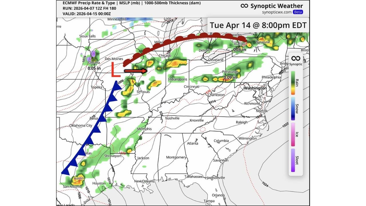
UNITED STATES — Early indications from long-range weather models are pointing toward a potential severe weather setup across the Midwest on Tuesday, April 14, as the atmosphere begins transitioning back into a more active pattern.
While details are still uncertain at this range, the overall setup suggests increasing storm potential across a broad region stretching from the central Plains into the Great Lakes and Ohio Valley.
Storm System Developing Across Central Plains
The setup begins with a developing low-pressure system centered near:
- Nebraska
- Kansas
- Iowa
A cold front is expected to extend southward through:
- Oklahoma
- Texas
This boundary will act as a trigger for storm development as it moves eastward.
Storms Expected To Expand Into Midwest
By Tuesday evening, the system is projected to push into:
- Missouri
- Illinois
- Indiana
- Michigan
- Ohio
Model guidance shows clusters of showers and thunderstorms forming along and ahead of the advancing front, especially in the central Midwest corridor.
Key Areas To Watch
Based on current projections, the most active zone may include:
- Eastern Missouri
- Central and northern Illinois
- Indiana
- Parts of Michigan
- Northern Ohio
These areas could see the most organized storm activity as the system progresses east.
Severe Potential Still Uncertain But Present
At this stage, it is too early to determine exact storm intensity, but the setup supports:
- Thunderstorm development along a frontal boundary
- Potential for organized storm clusters
- A return to a more active severe weather pattern
If atmospheric ingredients align more strongly in future updates, this system could evolve into a more significant severe event.
Timing Points To Evening And Overnight Risk
Current projections highlight:
- Tuesday afternoon into evening as the primary window
- Continued activity into the nighttime hours as storms move east
This timing could increase risk if storms persist after sunset.
Why This Pattern Matters
This setup marks a transition back into an active spring storm pattern, following quieter periods in some regions.
Key drivers include:
- A strengthening upper-level trough moving out of the western U.S.
- Increasing moisture return from the Gulf
- A sharpening frontal boundary across the Plains and Midwest
These elements are typical of early-season severe weather setups.
Important Reminder About Forecast Uncertainty
Because this event is still several days away:
- Exact locations of strongest storms may shift
- Severity levels may change significantly
- Additional updates will refine the risk zones
Residents should avoid focusing on exact details at this stage and instead stay aware of the overall pattern.
Final Outlook
A developing weather system could bring thunderstorms and potential severe weather to parts of the Midwest on Tuesday, April 14, particularly across Illinois, Indiana, Missouri, and surrounding states.
While it remains too early to confirm the full extent of impacts, the pattern suggests increasing storm activity as the region moves deeper into spring.
Residents across the Midwest should stay alert and monitor updates as this system evolves.
Stay with WaldronNews.com for the latest developments and refined forecasts as more details become available.