
Midwest And Plains States Including Iowa Illinois Wisconsin Missouri And Kansas Could See Multiple Days Of Tornado Potential April 13 And 14 So Residents Should Stay Alert To This Active Pattern
UNITED STATES — A developing severe weather pattern is drawing attention across the central United States, with forecast signals indicating multiple days of tornado potential over the next two weeks, and two specific days already standing out as higher concern.
Current projections highlight Monday, April 13 and Tuesday, April 14 as the most active periods within this evolving setup.
Tornado Risk Zone Centered Over Midwest And Upper Plains
The highest concentration of tornado potential is currently projected across:
- Iowa
- Wisconsin
- Northern Illinois
- Southern Minnesota
- Parts of Michigan
This region shows the strongest signal for organized severe weather, particularly on April 13, where a more concentrated risk area is indicated.
Secondary Risk Extends Into Southern Plains
In addition to the Midwest focus, a secondary zone of concern is developing farther south across:
- Kansas
- Oklahoma
- Northern Texas
This area could also experience storm development, especially as the system evolves and shifts.
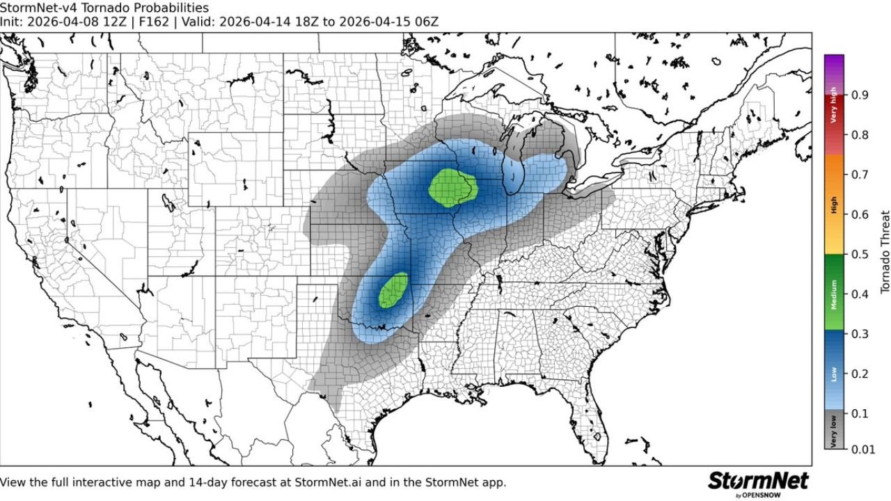
April 14 Expands Risk Area Across Central US
By Tuesday, April 14, the risk area becomes broader and more expansive, covering:
- Missouri
- Illinois
- Indiana
- Iowa
- Wisconsin
- Parts of the Great Lakes region
The pattern suggests a wider corridor of potential severe weather, increasing the number of states that could be impacted.
Multi Day Pattern Raises Concern
One of the key concerns with this setup is not just a single event, but a multi-day stretch of storm potential, which can increase overall risk.
Important factors include:
- Repeated storm development across similar regions
- Expanding storm coverage over time
- Increasing atmospheric energy as the pattern progresses
This type of setup can lead to cumulative impacts rather than isolated incidents.
Forecast Confidence Still Evolving
While the pattern is becoming clearer, it is important to note:
- Exact locations of highest tornado risk may shift
- Storm intensity and coverage will be refined in upcoming forecasts
- Long-range models are still adjusting to the evolving setup
Residents should focus on the broader signal rather than specific details at this stage.
Why This Pattern Matters Now
The early identification of multiple potential severe weather days allows for:
- Better preparation and awareness
- Monitoring of future forecast updates
- Early readiness for rapidly changing conditions
Spring is a peak season for severe weather, and patterns like this can escalate quickly.
Areas To Watch Closely
Based on current data, the most important regions to monitor include:
- Midwest states from Iowa to Illinois and Wisconsin
- Central Plains including Kansas and Oklahoma
- Expanding zones into the Great Lakes
These areas could see the most consistent storm activity over the highlighted period.
Final Outlook
The central United States is entering a more active severe weather pattern, with multiple days of tornado potential possible, especially around April 13 and 14.
While details remain uncertain, the consistent signal across multiple forecast models highlights a pattern that should not be ignored.
Residents across the Midwest and Plains should stay weather aware and continue monitoring updates as this situation develops.
Stay with WaldronNews.com for ongoing coverage and updates on this evolving severe weather threat.