
Tennessee, Georgia, Alabama and Carolinas Facing Rising Drought and Heat Risk So Residents Should Prepare for Worsening Conditions Next Week
TENNESSEE — A concerning weather pattern is beginning to take hold across the Southeast, where above-normal temperatures and limited rainfall are expected to rapidly intensify drought conditions heading into next week.
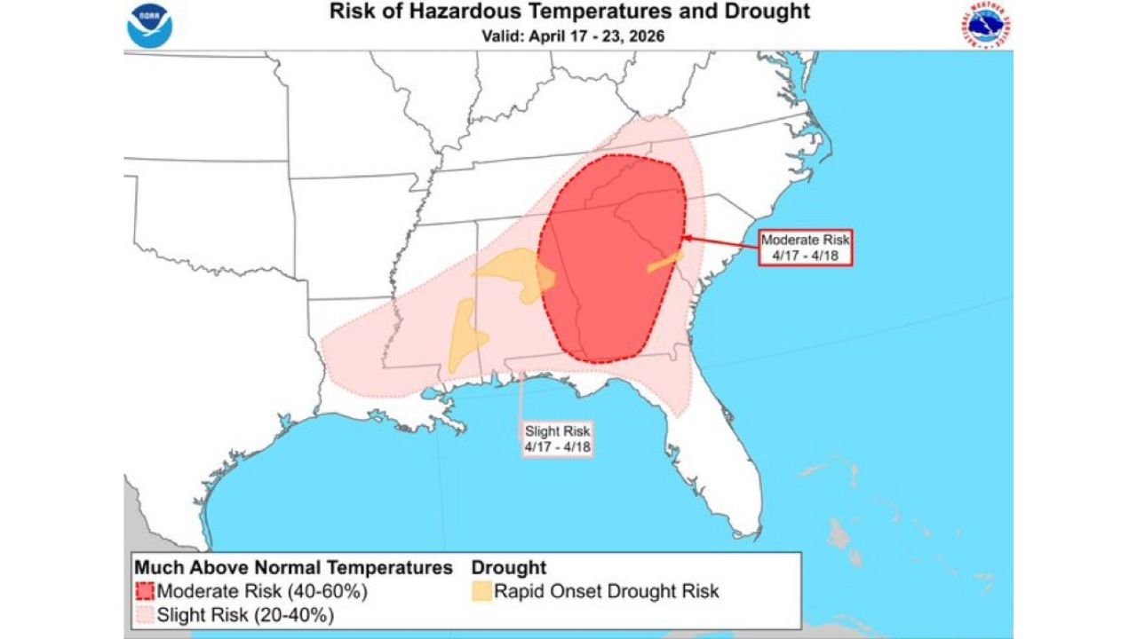
Forecast guidance shows a growing overlap of heat risk and developing drought, particularly across parts of the Tennessee Valley and surrounding states.
Drought Conditions Expected to Worsen Quickly
The latest outlook highlights a rapid onset drought risk across portions of:
- Tennessee
- Northern Alabama
- Northern Georgia
- Parts of Mississippi
Rainfall chances remain limited, with only widely scattered showers expected, and those will not be enough to significantly improve soil moisture levels.
As a result, dry ground conditions are expected to deteriorate further through next week.
Heat Building Across the Southeast
At the same time, temperatures are trending well above seasonal averages:
- Highs in the 80s expected on most days
- Some areas approaching near-record warmth
- Persistent warmth reducing overnight cooling
This combination of heat and dryness will accelerate evaporation, further worsening drought conditions.
Moderate Risk Zone Expands Across Georgia and Carolinas
The hazard outlook map shows a moderate risk (40–60%) of much above normal temperatures centered over:
- Much of Georgia
- South Carolina
- Parts of North Carolina
Surrounding areas, including Alabama and the Florida Panhandle, are under a slight risk (20–40%), indicating a broader region experiencing abnormal warmth.
Wildfire Risk Increasing Across Multiple States
With dry soils and rising temperatures, wildfire potential is expected to increase significantly, especially in:
- Forested areas of Georgia and the Carolinas
- Dry zones in Alabama and Tennessee
- Regions experiencing repeated days of low humidity and warmth
Even without extreme heat, the lack of sustained rainfall combined with warming temperatures creates ideal conditions for fire spread.
Limited Rainfall Offers Little Relief
Although a few showers may develop at times:
- Coverage will be isolated to scattered at best
- Rainfall totals will be too low to reverse drying trends
- Many areas may see little to no measurable rain
This reinforces the likelihood of continued drying through mid to late April.
Timing of the Most Impactful Period
The most critical window appears to be:
- April 17 through April 23
- Peak heat and drought overlap early in this period
- Conditions may persist or worsen beyond this window if the pattern holds
What This Means for the Region
This developing pattern is significant because:
- It marks a rapid transition toward drought conditions
- Comes early in the warm season when vegetation is becoming active
- Increases strain on water resources and agriculture
- Raises early-season wildfire concerns
Final Outlook
A dangerous combination of heat and drying conditions is expected across Tennessee, Georgia, Alabama, and the Carolinas next week, with drought intensifying and wildfire risk climbing.
With limited rainfall in sight and temperatures staying well above normal, the region is entering a period that requires close monitoring.
Residents should begin preparing for continued dry weather, elevated fire risk, and prolonged warmth as this pattern develops.
Stay with WaldronNews.com for further updates as conditions evolve across the Southeast.