
Texas, Oklahoma and Kansas Severe Weather Alert Issued for Saturday as Storm Models Highlight Hail and Damaging Wind Risk Zones
TEXAS — A new severe weather outlook has been issued ahead of Saturday (April 11), highlighting a developing storm setup across the Southern Plains and parts of the Midwest that residents should monitor closely.
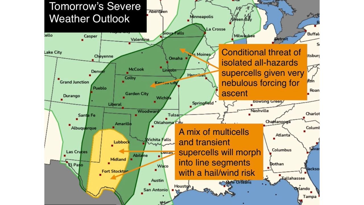
Forecast data shows a Slight Risk (Level 2 out of 5) for severe storms, with the highest concern centered over west Texas and nearby regions, where storms could intensify quickly.
West Texas Identified as Primary Risk Zone
The most significant threat area includes:
- Lubbock
- Midland
- Fort Stockton
- Surrounding west Texas regions
Storms in this zone are expected to develop into a mix of multicells and transient supercells, which could later organize into line segments.
This setup increases the likelihood of:
- Large hail
- Damaging straight-line winds
Storm Evolution Could Increase Impact
As storms grow and merge, they are expected to:
- Transition from isolated cells into organized storm lines
- Expand coverage across parts of Texas into Oklahoma
- Increase wind damage potential as storms cluster together
This type of evolution often leads to broader impact zones rather than isolated storms.
Oklahoma and Kansas Also Under Watch
Areas extending north into:
- Oklahoma City
- Wichita
- Kansas City
- Omaha
are included in a broader risk zone, though the threat here appears more uncertain.
Conditional but Notable Northern Threat
Farther north, forecasters highlight a conditional risk of isolated supercells.
This means:
- Storm development is not guaranteed
- But if storms do form, they could produce all hazards, including:
- Hail
- Damaging winds
- Possibly a tornado
The uncertainty is tied to weaker atmospheric forcing, meaning storms may struggle to initiate—but could become dangerous if they do.
What Makes This Setup Important
This system combines:
- Instability across the Plains
- Favorable conditions for storm organization
- A wide geographic coverage area
Even with some uncertainty, the setup supports scattered severe storms across multiple states.
Timing Overview
- Saturday Afternoon: Storms begin developing in west Texas
- Saturday Evening: Peak intensity and expansion into Oklahoma
- Saturday Night: Storms may organize into lines and push northeast
Final Outlook
A multi-state severe weather setup is expected Saturday, with the greatest confidence for hail and damaging wind risks in west Texas, and a broader but more uncertain threat extending into Oklahoma, Kansas, and parts of the Midwest.
Residents in Lubbock, Midland, Oklahoma City, Wichita, and Kansas City should stay weather aware as conditions evolve.
Stay with WaldronNews.com for continued updates as this developing severe weather situation becomes clearer.