
Oklahoma and North Texas Severe Storm Alert Issued as Large Hail Threat Emerges for Saturday Night Storms
OKLAHOMA — A new severe weather alert is drawing attention across southwest Oklahoma and north Texas, where storm conditions are expected to support large hail and damaging winds heading into Saturday night.
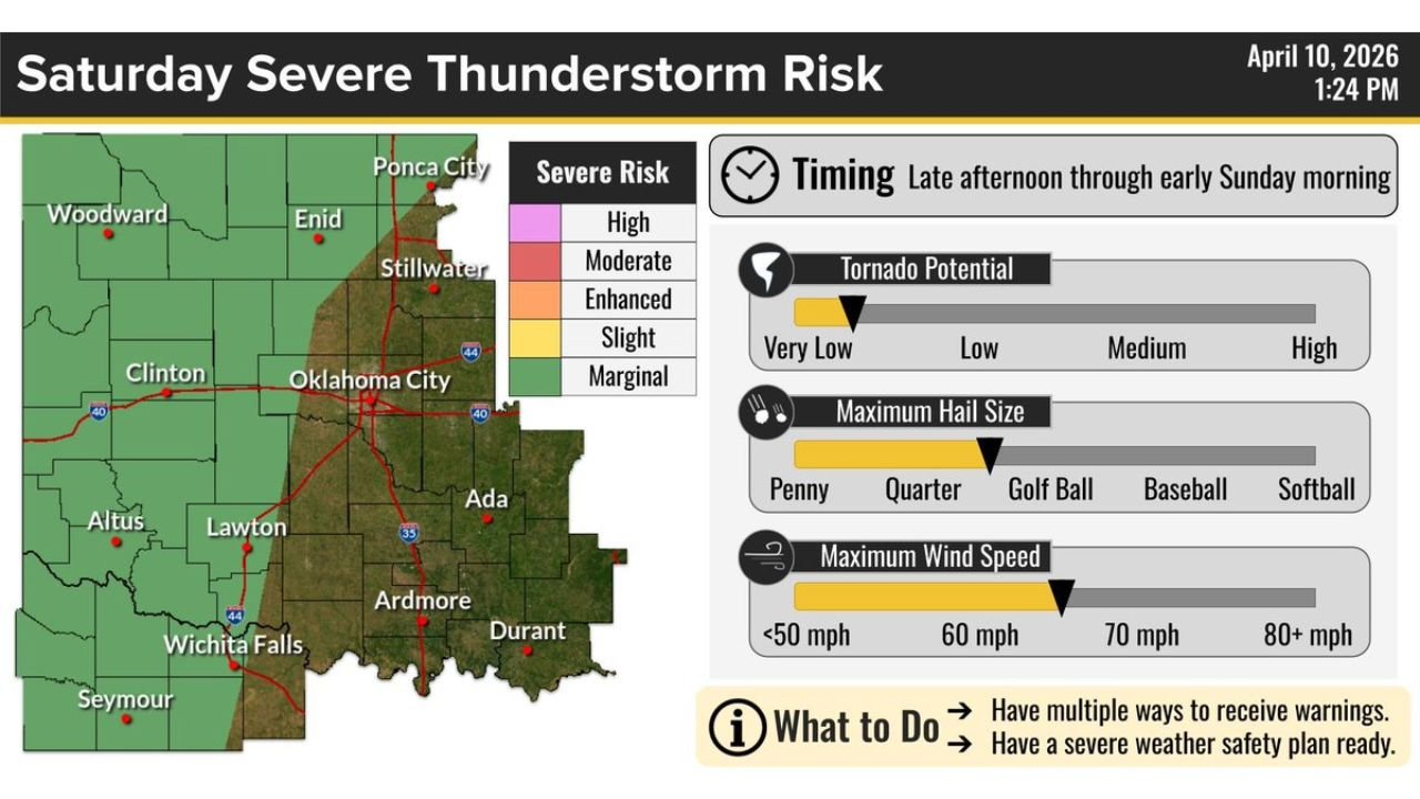
Recent data and storm outlook visuals highlight a growing thunderstorm risk across areas including Lawton, Altus, Wichita Falls, and surrounding Texoma regions, with conditions favorable for intense storm development.
Large Hail Threat Becoming the Main Concern
Forecast indicators suggest storms could produce:
- Large hail potentially reaching golf ball size or larger
- Damaging wind gusts
- Brief heavy rainfall in stronger cells
Visual evidence associated with the forecast shows significant hail accumulation and large, jagged hailstones, reinforcing the seriousness of this setup.
Target Area Includes Southwest Oklahoma and North Texas
The highest risk zone currently focuses on:
- Lawton, OK
- Altus, OK
- Wichita Falls, TX
- Surrounding Texoma region
These areas fall within a favorable storm environment for hail-producing thunderstorms, especially during the evening and overnight hours.
Storm Timing and Development
- Saturday Afternoon: Storms begin forming west of the region
- Saturday Evening: Stronger storms move into southwest Oklahoma and north Texas
- Saturday Night: Peak severe threat with hail and gusty winds
Storms are expected to develop into clusters or line segments, which can increase wind risk while still producing large hail in stronger cores.
What Makes This Setup Dangerous
This system includes:
- Strong atmospheric instability
- Conditions supportive of rotating storm structures
- Potential for storms to intensify quickly after forming
Even short-lived storms in this environment can produce significant hail damage to vehicles, roofs, and outdoor property.
Areas Outside Main Zone Still Need Awareness
While the highest risk is focused in southwest Oklahoma and north Texas, nearby regions including:
- Central Oklahoma
- Southern Kansas
could still see isolated strong storms, though coverage and intensity may vary.
Final Outlook
A targeted but potentially impactful severe weather setup is expected Saturday night, with large hail and damaging winds posing the biggest threats across Lawton, Altus, Wichita Falls, and surrounding areas.
Residents are urged to stay alert, especially during the evening and overnight hours when storms may intensify quickly.
Stay connected with WaldronNews.com for real-time updates as this severe weather situation unfolds.