
Wisconsin Minnesota and Upper Midwest Weather Alert New Elevated Tornado Threat Zone Emerging for Tuesday April 14 Residents Urged to Stay Ready
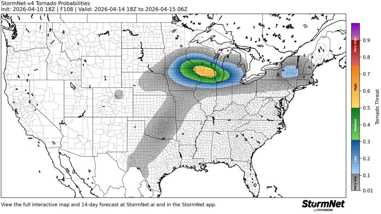
WISCONSIN — A new elevated tornado threat is now being signaled for Tuesday, April 14, 2026, with the highest concern centered across parts of the Upper Midwest, including southern Minnesota and western to central Wisconsin.
This developing setup highlights a more focused and potentially impactful severe weather zone, especially compared to earlier broad outlooks.
Core Tornado Risk Area Identified
The latest data shows a concentrated zone of higher tornado potential, including:
- Southern Minnesota
- Western and central Wisconsin
This area is marked by a stronger probability signal, indicating a more favorable environment for tornado development compared to surrounding regions.
Surrounding Risk Expands Beyond Core Zone
A broader region surrounding the core includes:
- Eastern Minnesota
- Much of Wisconsin
- Northern Illinois
- Parts of Michigan
Within this wider zone, conditions still support:
- Severe thunderstorms
- Isolated tornado potential
- Damaging wind and hail risks
However, the highest confidence remains in the Minnesota–Wisconsin corridor.
Timing of the Severe Weather Threat
- Primary window: Tuesday afternoon into evening
- Continuation: Into early Wednesday morning
This suggests storms may:
- Intensify during the evening hours
- Continue overnight as they track eastward
What Makes This Setup Important
The data highlights:
- A well-defined tornado probability zone, not just a general risk
- Increasing atmospheric support for organized storm structures
- Potential for multiple severe hazards in the same region
This type of signal typically indicates a more serious severe weather setup compared to marginal or scattered events.
Main Threats Expected
Across the impacted region, storms may produce:
- Tornadoes (primary concern in highlighted zone)
- Large hail
- Damaging wind gusts
The overlap of these threats means storms could become dangerous quickly, especially in the highest risk zone.
Why Residents Should Pay Attention
Even though this is still a forecast setup:
- The signal for tornado potential is clearly elevated
- The risk area is more focused than typical early outlooks
- Changes in storm track could shift impacts into nearby states
Final Update
A new elevated tornado threat has been identified for Tuesday, April 14 across Wisconsin and Minnesota, with the highest concern centered over southern Minnesota into central Wisconsin.
Surrounding areas including Illinois and Michigan may also see severe storms, but the core tornado risk remains focused in the Upper Midwest.
Residents are strongly encouraged to stay alert and monitor updates as this developing severe weather setup becomes clearer.
Stay with WaldronNews.com for continuous tracking and real-time updates on this evolving situation.