
Utah New Weather Update Warns Northern and Eastern Utah Residents to Watch Weekend Storm Then Bigger Statewide System Next Week
UTAH — A developing weather pattern is set to impact parts of the state this weekend, bringing scattered showers and isolated thunderstorms across northern and eastern Utah on Saturday, followed by a stronger second storm early next week that could deliver more widespread precipitation and cooler temperatures.
Storm #1 Brings Spotty Rain and Storm Chances Saturday
The first system moving into Utah will not be a complete washout, but it will bring scattered showers and isolated thunderstorms, mainly affecting northern and eastern Utah during the day on Saturday.
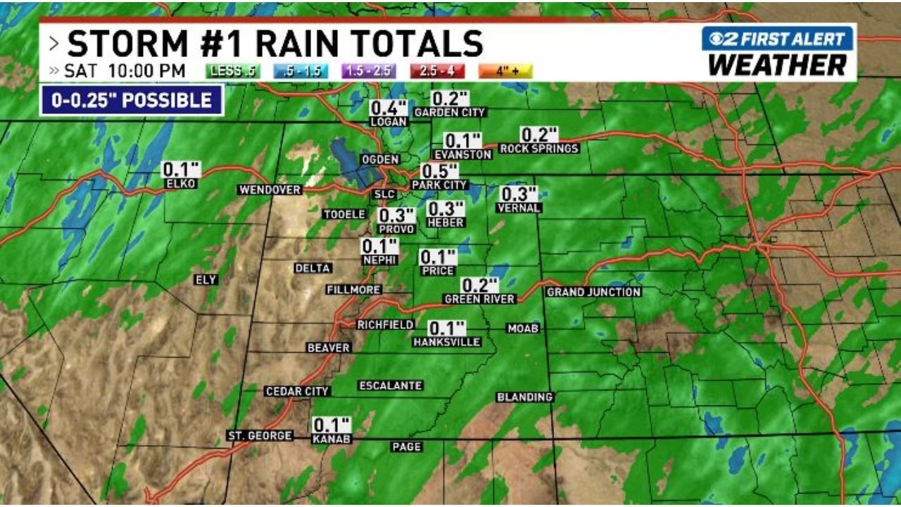
Rainfall is expected to be highly uneven, with some areas staying completely dry while others pick up light amounts. Forecast totals indicate:
- Around 0.1″ to 0.5″ in parts of northern Utah
- Logan near 0.4″
- Ogden around 0.5″
- Salt Lake City, Provo, and Heber near 0.3″
- Vernal around 0.3″
- Evanston and Rock Springs near 0.1″ to 0.2″
Further south and west, totals drop off significantly:
- Nephi, Price, Hanksville, and Kanab around 0.1″
- Green River near 0.2″
- Elko and western areas closer to 0.1″ or less
Overall, most locations will see between 0 and 0.25 inches, with the highest chances of measurable rain occurring from late morning through the afternoon hours.
Not Everyone Will See Rain
A key part of this setup is the scattered nature of precipitation. While radar may show widespread activity, the reality on the ground will vary:
- Some communities may experience brief showers or a thunderstorm
- Others may see little to no rainfall at all
This uneven distribution is typical with weaker storm systems like this one.
Storm #2 Expected to Bring Bigger Changes
A second, more impactful storm system is expected to arrive Sunday night and continue through Tuesday, bringing:
- More widespread precipitation across Utah
- Increased coverage compared to the weekend system
- Cooler temperatures statewide
This second system is expected to have a broader reach, meaning more areas across Utah could see consistent rainfall compared to the spotty nature of Saturday’s storm.
Temperature Drop Likely Early Next Week
Along with increased precipitation, temperatures are expected to trend cooler statewide as the second storm settles in. This will mark a noticeable shift after the relatively mild conditions leading into the weekend.
What Residents Should Watch For
- Saturday: Scattered showers and isolated thunderstorms, mainly north and east
- Rainfall: Generally light, with localized pockets up to around 0.5″
- Sunday Night–Tuesday: More widespread rain with cooler conditions
- Uncertainty: Rain coverage will vary significantly from one location to another
Residents in Logan, Ogden, Salt Lake City, Provo, Vernal, and surrounding northern/eastern Utah areas have the best chance to see measurable rainfall during the first system.
As the second storm approaches, conditions will become more consistent across the state, making early next week the period to watch for more meaningful precipitation.
Stay with WaldronNews.com for continued updates as Utah’s two-part storm system develops.