
Alabama Drought Worsening as Rain Stays Away Through Next Week but a Pattern Change Bringing Storms and Relief Is Building for Late April
BIRMINGHAM, Alabama — Alabama is entering one of its driest and most difficult stretches of the spring season, as a warm, dry, and increasingly dangerous drought pattern is forecast to persist across the state for the next 5 to 7 days — pushing already stressed soil conditions further into deficit territory while the rest of the central United States deals with an active severe weather outbreak that is almost entirely bypassing the Deep South.
The 7-day precipitation forecast through Sunday, April 19 tells the story bluntly — virtually the entire state of Alabama is showing near-zero rainfall through next weekend, with the active storm systems driving heavy rain across the Mississippi Valley and central Plains tracking far enough north to deliver nothing meaningful to Birmingham, Huntsville, Montgomery, Mobile, or any other major Alabama community.
What the Next 7 Days Look Like for Alabama
The 7-day precipitation map ending Sunday, April 19 at 8 PM EDT shows a stark and troubling picture for Alabama and the broader Deep South:
- Alabama statewide: Essentially 0.0 to 0.1 inches of rainfall forecast through April 19 — the entire state is colored white on the precipitation map, indicating negligible to no measurable rainfall expected
- Mississippi: Similarly dry conditions dominate with minimal precipitation forecast statewide
- Georgia and the Carolinas: The eastern Southeast corridor also remains largely dry through next weekend
- Florida: Near-zero precipitation is forecast for most of the state through April 19
- The contrast: Meanwhile, the active storm systems producing heavy rainfall of 1.0 to 1.7+ inches are tracking across Arkansas, Missouri, Tennessee, and the central Plains — completely missing Alabama and the Deep South
Drought Conditions Are Worsening — What That Means on the Ground
Alabama’s soil moisture was already running below normal heading into this week, and 5 to 7 more days of warm, dry conditions with no meaningful rainfall will push drought conditions measurably worse across the state. For Alabama residents, farmers, and land managers, this progression carries real and immediate consequences:
For agriculture, topsoil moisture is rapidly depleting across Alabama’s farming communities at the exact moment when spring planting and early crop establishment demand consistent moisture. Corn, soybeans, cotton, and pasture grasses across the state are being stressed during a critical growth window, and each additional day without rain deepens the deficit that will need to be overcome later in the season.
For fire weather, the combination of warm temperatures, low humidity, and dry vegetation creates increasingly dangerous conditions across Alabama’s rural and forested communities. Any outdoor burning during this stretch carries elevated risk of rapid fire spread, and residents across the state should exercise extreme caution with any ignition sources outdoors through the middle of next week.
For water resources, rivers, ponds, and reservoirs across Alabama that have not fully recovered from earlier dry conditions are seeing continued stress as the dry pattern locks in through April 19.
The Relief Signal — Late April Pattern Change
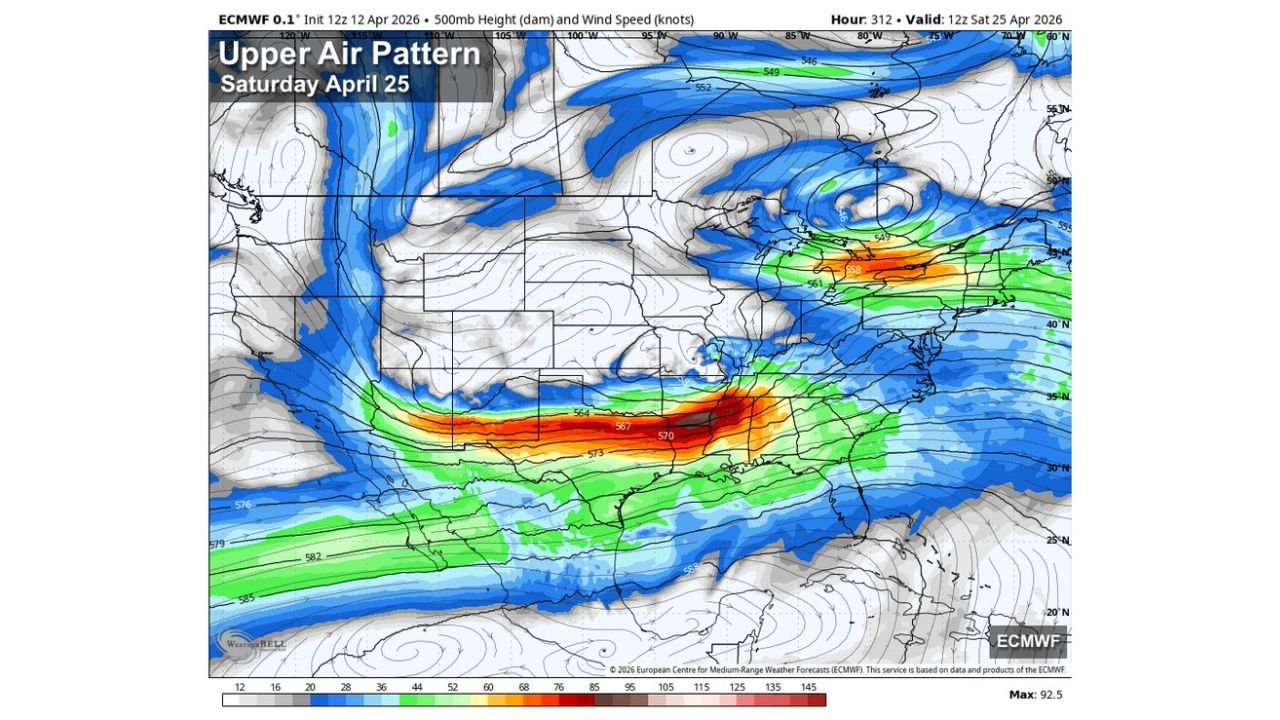
The drought story does not end without hope. A significant pattern change is building for 10 to 15 days out — and the upper-level atmospheric data for Saturday, April 25 shows exactly why forecasters are increasingly confident that active weather and much higher chances for rain and thunderstorms are coming back to the Deep South in the final week of April.
The 500mb upper air pattern map valid Saturday, April 25 shows a dramatically different atmospheric setup compared to this week. A powerful jet stream — shown in deep red and orange indicating wind speeds of 92+ knots — is forecast to blast directly across the Tennessee Valley and Deep South corridor by late April, replacing the stagnant, dry high-pressure pattern that has been baking Alabama this week. This kind of upper-level energy streaming across the region is precisely the atmospheric configuration that drives active storm development, increased rainfall, and the pattern relief that Alabama desperately needs.
This late-April pattern shift is being reinforced by the same large-scale atmospheric oscillation driving weather patterns globally — which is transitioning into phases historically associated with increased storm activity and wetter conditions across the southeastern United States. The timing points consistently to the last 10 days of April as the window when conditions across Alabama and the Deep South turn meaningfully wetter and more active.
What Alabama Residents Need to Watch
- Drought conditions will worsen through April 19 — water conservation, fire safety, and agricultural monitoring are all important priorities through next weekend
- Any outdoor burning, campfires, or land clearing in Alabama should be avoided or approached with extreme caution through the dry stretch — fire weather conditions are deteriorating
- The late April pattern change around April 20-25 is the target window for Alabama’s first significant rainfall chances — watch for this timeline to sharpen in coming days as confidence increases
- The upper-level jet stream setup for April 25 is a strong signal that active weather is coming — but the same pattern that brings relief can also bring severe storms, so residents should stay weather-aware as the pattern shifts
- Farmers and landowners across Alabama should begin monitoring 10-day outlooks closely as the pattern change window approaches — the shift from extreme dry to active could come quickly
- Birmingham, Huntsville, Montgomery, and Mobile residents should anticipate a meaningful change in weather character in the final week of April after a very dry first three weeks of the month
Alabama needs rain, and the atmosphere is slowly building toward delivering it — but not before 5 to 7 more difficult dry days push drought conditions further across the state. The relief is coming in late April, and when it arrives, it may arrive with force.
WaldronNews.com will continue tracking Alabama’s drought conditions and the developing late April pattern change across the Deep South and will provide updates as the rainfall timeline becomes clearer.