
National Weather Service Issues Enhanced Risk for Minnesota and Wisconsin Monday as 70 mph Winds, 2 to 3 Inch Hail and Strong Tornadoes Threaten Minneapolis, St. Paul and Eau Claire Between 4pm and 6pm
MINNEAPOLIS, Minnesota — The National Weather Service has issued an Enhanced Risk — Level 3 out of 5 severe weather outlook for Monday, April 13 across much of southern Minnesota through western Wisconsin, as a powerful warm front erupting between 4:00 PM and 6:00 PM threatens to unleash thunderstorms capable of all severe weather hazards simultaneously — including wind gusts up to 70 mph, hail up to 2 to 3 inches in diameter, and strong tornadoes across the Minneapolis, St. Paul, Mankato, Rochester, and Eau Claire corridor.
This is the first significant severe weather risk of the year for the region — and the NWS Twin Cities/Chanhassen office is not holding back in its warning tone, describing favorable severe weather parameters coming together across the Upper Midwest in a setup that demands immediate attention and preparation from every resident in the risk zone.
Communities Facing the Monday Severe Weather Threat
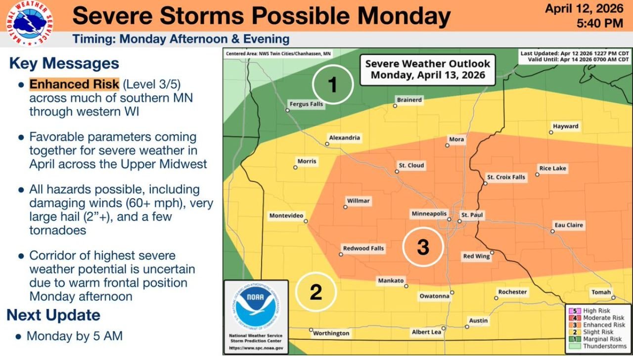
- Minnesota — Enhanced Risk (Level 3): Minneapolis, St. Paul, St. Cloud, Willmar, Mankato, Owatonna, Rochester, Red Wing, Fergus Falls, Alexandria, Morris, Montevideo, Redwood Falls, and Albert Lea
- Wisconsin — Enhanced Risk corridor: Eau Claire, St. Croix Falls, Rice Lake, Tomah, and the broader western Wisconsin communities sit inside the Enhanced Risk zone
- Minnesota — Slight Risk (Level 2): Worthington and the southern Minnesota border communities carry a Slight Risk designation
- Minnesota — Marginal to Thunderstorm Risk (Level 1): Brainerd, Hayward, and the northern fringe communities are on the outer edge of Monday’s storm threat
Three Simultaneous Threats — All on the Table at Once
The NWS Severe Hazards breakdown for Monday afternoon and evening identifies three separate and equally serious threats all arriving at the same time:
Wind — Gusts Up to 70 mph: The severe wind outlook covers the entire southern Minnesota and western Wisconsin corridor with the highest wind threat concentrated near the warm front. Gusts reaching 70 mph are capable of downing large trees, snapping power poles, destroying outbuildings, and creating life-threatening conditions for anyone outdoors or in a vehicle. This level of wind damage is equivalent to a weak tornado in terms of destructive capability on structures and the landscape.
Hail — Up to 2 to 3 Inches in Diameter: The severe hail outlook shows a large zone of significant hail potential across southern Minnesota and into western Wisconsin. Hail reaching 2 to 3 inches in diameter — the size of a baseball to a softball — is capable of destroying vehicle windshields, stripping roofing materials, devastating crops, injuring livestock, and causing serious injury to anyone caught outdoors. Every vehicle in the Enhanced Risk zone should be under cover before 4 PM Monday.
Tornadoes — Strong Tornadoes Possible: The tornado outlook for Monday shows a meaningful tornado probability across the Minneapolis-St. Paul metro and surrounding southern Minnesota communities. The NWS explicitly states strong tornadoes are possible — meaning the threat extends beyond brief spin-ups to potentially long-track, violent rotating storms capable of significant structural damage. For a region experiencing its first severe weather risk of the year, this tornado signal is unusually serious.
The Critical Forecast Question — How Far North Does the Warm Front Lift?
The Monday Afternoon Snapshot from the NWS Twin Cities office identifies the single most important forecast variable for Monday’s severe weather: how far north the warm front lifts by afternoon.
The yellow outlined region on the NWS snapshot map — stretching from Montevideo and Willmar east through Minneapolis, St. Paul, Mankato, Rochester, and La Crosse — represents the area where the warm front is forecast to stall out Monday afternoon. This stalling boundary is where atmospheric energy, moisture, and wind shear will be most concentrated, and therefore where the corridor of highest severe weather potential will be focused.
The NWS is explicit that the exact position of this warm front remains uncertain heading into Monday — which means the corridor of greatest danger could shift north or south of current expectations. Communities north of the current forecast boundary that end up under the warm front’s actual stall point could experience conditions worse than currently indicated, while communities south of the boundary may see a less severe outcome. This uncertainty makes it critical for every community from Fergus Falls south to the Iowa border to treat Monday as a high-alert day regardless of where they fall on the current risk maps.
Why Monday Is a Historic Severe Weather Day for Minnesota and Wisconsin
The NWS Twin Cities explicitly described Monday’s setup as the result of favorable severe weather parameters coming together for April across the Upper Midwest — language that reflects genuine forecaster concern about an atmospheric configuration that is unusually potent for this early in the spring season.
The Minneapolis-St. Paul metro area — home to millions of residents — sits directly inside the Enhanced Risk zone and directly within the warm front stall region identified as the highest threat corridor. For an urban area of this size to be under an Enhanced Risk with all hazards simultaneously on the table during the very first severe weather event of the year, this is not a routine spring storm. It is a significant, multi-hazard severe weather event that warrants the same level of preparation and urgency as any major outbreak.
The 4 PM to 6 PM timing window is particularly dangerous because it coincides with afternoon school dismissal, evening commutes, and peak outdoor activity hours — when millions of people across the metro are transitioning between home, school, and work. Getting indoors and into shelter before 4 PM is the single most important action every resident in the risk zone can take Monday.
What to Do Before 4 PM Monday
- Get indoors and into a sturdy shelter before 4 PM — the warm front is expected to trigger rapid storm development during the 4-6 PM window and conditions can deteriorate within minutes
- Move all vehicles into a garage or covered structure before Monday afternoon — 2 to 3 inch hail will cause catastrophic damage to any vehicle left outdoors
- Residents in Minneapolis, St. Paul, Mankato, Rochester, and Eau Claire should identify their lowest-floor interior room away from windows and be ready to move there immediately when tornado warnings are issued
- Have multiple ways to receive warnings active — NWS weather radio, phone emergency alerts, and a trusted weather app all running simultaneously Monday afternoon
- Do not rely on hearing outdoor sirens as your only warning system — be inside and monitoring alerts actively before the 4 PM storm initiation window arrives
- The NWS Twin Cities will issue a next update by 5 AM Monday — check this update first thing Monday morning for any changes to the risk area or threat level
- Parents and schools across southern Minnesota and western Wisconsin should have severe weather plans confirmed before Monday morning
The atmosphere is loaded, the warm front is primed, and the 4 PM to 6 PM window Monday is when conditions across southern Minnesota and western Wisconsin could turn dangerous very quickly. Every resident in the Minneapolis, St. Paul, Mankato, Rochester, and Eau Claire area needs to be inside, sheltered, and actively monitoring weather alerts before Monday afternoon arrives.
WaldronNews.com will continue tracking Monday’s Enhanced Risk severe weather outbreak across Minnesota and Wisconsin and will provide updates following the NWS 5 AM Monday morning briefing.